The Beaches is a neighbourhood in Toronto, Ontario, Canada. It is so named because of its four beaches situated on Lake Ontario. It is located east of downtown within the "Old" City of Toronto. The approximate boundaries of the neighbourhood are from Victoria Park Avenue on the east to Kingston Road on the north, along Dundas Street to Coxwell Avenue on the west, south to Lake Ontario. The Beaches is part of the east-central district of Toronto.

Riverdale is a large neighbourhood in Toronto, Ontario, Canada. It is bounded by the Don River Valley to the west, Danforth Avenue and Greektown to the north, Jones Avenue, the CN/GO tracks, Leslieville to the east, and Lake Shore Boulevard to the south.

Parkdale is a neighbourhood and former village in Toronto, Ontario, Canada, west of downtown. The neighbourhood is bounded on the west by Roncesvalles Avenue, on the north by the CP Rail line where it crosses Queen Street and Dundas Street. It is bounded on the east by Dufferin Street from Queen Street south, and on the south by Lake Ontario. The original village incorporated an area north of Queen Street, east of Roncesvalles from Fermanagh east to the main rail lines, today known as part of the Roncesvalles neighbourhood. The village area was roughly one square kilometre in area. The City of Toronto government extends the neighbourhood boundaries to the east, south of the CP Rail lines, east to Atlantic Avenue, as far south as the CN Rail lines north of Exhibition Place, the part south of King Street commonly known as the western half of Liberty Village neighbourhood.

Roncesvalles is a neighbourhood in the city of Toronto, Ontario, Canada, centred on Roncesvalles Avenue, a north–south street leading from the intersection of King and Queen Streets to the south, north to Dundas Street West, a distance of roughly 1.7 kilometres. It is located east of High Park, north of Lake Ontario, in the Parkdale–High Park provincial and federal ridings and the municipal Ward 4. Its informal boundaries are High Park to the west, Bloor Street West to the north, Lake Ontario/Queen Street West to the south and Lansdowne Avenue/rail corridor to the east. Originally known as "Howard Park", most of this area was formerly within the boundaries of Parkdale and Brockton villages and was annexed into Toronto in the 1880s.

King Street is a major east–west commercial thoroughfare in Toronto, Ontario, Canada. It was one of the first streets laid out in the 1793 plan of the town of York, which became Toronto in 1834. After the construction of the Market Square in 1803 at King and Jarvis streets, to house the first St. Lawrence Market farmer's market, the street became the primary commercial street of York and early Toronto. This original core was destroyed in the 1849 Great Fire of Toronto, but subsequently rebuilt. The original street extended from George to Berkeley Street and was extended by 1901 to its present terminuses at Roncesvalles Avenue in the west and the Don River in the east.

Newtonbrook is a neighbourhood in Toronto, Ontario, Canada. It is located in the area around Yonge Street and Finch Avenue in the district of North York between the east and west branches of the Don River. Officially, the area is divided into two neighbourhoods; Newtonbrook West and Newtonbrook East.

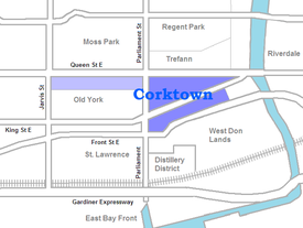
Front Street is an east–west road in downtown Toronto, Ontario, Canada. First laid out in 1796, the street is one of the original streets of the Town of York. The street was laid out along the shoreline of Lake Ontario as it existed during that time. It remains an important street, with many important uses located along it, including the St. Lawrence Market, Meridian Hall, Union Station and the Metro Toronto Convention Centre. The eastern section of Front Street, in the West Don Lands, east of Cherry Street, is being rebuilt as a broad tree-lined boulevard, intended to be the pedestrian-friendly commercial spine of the new neighbourhood.

The Garden District is a neighbourhood in downtown Toronto, Ontario, Canada. The name was selected by the Toronto East Downtown Residents Association (TEDRA) in recognition of Allan Gardens, an indoor botanical garden located nearby at the intersection of Carlton and Jarvis Streets. The Garden District was officially designated by the Mayor and Toronto City Council in 2001, while TEDRA has since been renamed the Garden District Residents Association. Part of the neighbourhood is within official City of Toronto neighbourhood of Moss Park.

St. Paul's Basilica is the oldest Roman Catholic congregation in Toronto, Ontario, Canada. It is located at 83 Power Street in the Corktown neighbourhood, just east of downtown, near the intersection of Queen and Parliament streets.

Niagara is a neighbourhood in Toronto, Ontario, Canada, located south of Queen Street West; it is usually bordered by Strachan Avenue to the west, Bathurst Street to the east, and the railway corridor to the south, and so named because Niagara Street runs through the centre of it. The eastern portion of this area was first planned as the New Town Extension when Toronto was incorporated as a city. The area was developed as a residential area for the workers of industries located along the CN and CP railway corridors. It remains a working-class neighbourhood that has seen the development of new condominium apartment buildings.

Little Trinity Anglican Church is a parish church of the Anglican Church of Canada. It is located at 425 King Street East in the Corktown neighbourhood, just east of downtown Toronto, Ontario, Canada. An Ontario Heritage Trust plaque at the site notes that the 1844 church is the oldest surviving church in the city.

Downtown Toronto is the main central business district of Toronto, Ontario, Canada. Located entirely within the district of Old Toronto, it is approximately 16.6 square kilometres in area, bounded by Bloor Street to the northeast and Dupont Street to the northwest, Lake Ontario to the south, the Don Valley to the east, and Bathurst Street to the west. It is also the home of the municipal government of Toronto and the Government of Ontario.

The Queensway–Humber Bay, known officially as Stonegate–Queensway, is a neighbourhood in the southwest of Toronto, Ontario, Canada. It is located in the southeast area of the former City of Etobicoke.

Inglenook Community High School is a Toronto public high school in Toronto, Ontario, Canada which offers grade 10, 11, and 12 level courses. It is housed in an historical building designed by William George Storm in the Corktown neighbourhood of downtown Toronto. The school has, on average, one hundred students and six teachers. It is located in the oldest continually-operated school building of the Toronto District School Board.
Main Street is a street in Hamilton, Ontario, Canada.

The West Don Lands are the site of a neighbourhood under construction in Toronto, Ontario, Canada. The area is bordered by the Don River, King Street, Parliament Street and the rail line adjacent to the Gardiner Expressway. It is 80 hectares in size. A former industrial area, the area is being rebuilt as a mixed-use neighbourhood.
Parliament Street is a north–south street in the eastern part of downtown Toronto, Ontario, Canada. The street runs from Bloor Street to Queens Quay and is the first major street west of the Don River.

Enoch Turner Schoolhouse is a historic site and museum in Toronto, Ontario, Canada. It is a former school owned by the Ontario Heritage Trust. The school was built in 1848 when it was known as the Ward School. The building is located at 106 Trinity Street between King Street East and Eastern Avenue. It is the oldest school standing in the city.

Old Town is a neighbourhood and retail district in downtown Toronto, Ontario, Canada. It was the first of Toronto's named neighbourhoods, having acquired the moniker no later than 1815, at which time the original town of York was expanding. The old neighbourhood was referred to as "Old Town" by residents, and the new neighbourhood as "New Town". The site still has many buildings dating back to the nineteenth century.