
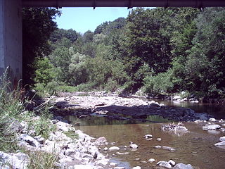
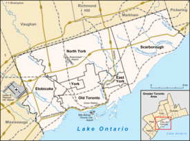
Etobicoke is an administrative district and former city within Toronto, Ontario, Canada. Comprising the city's west-end, Etobicoke is bordered on the south by Lake Ontario, on the east by the Humber River, on the west by Etobicoke Creek, the cities of Brampton, and Mississauga, the Toronto Pearson International Airport, and on the north by the city of Vaughan at Steeles Avenue West.

The Kingsway is a residential neighbourhood in Toronto, Ontario, Canada. It is bounded by Bloor Street to the south, Dundas Street to the north, the Mimico Creek to the west and the Humber River to the east. The neighbourhood was officially known as Kingsway Park, which later became replaced by its nickname, The Kingsway. For planning purposes, the neighbourhood is known by the City of Toronto as "Kingsway South" to differentiate it from a more recent extension of The Kingsway north of Dundas Street. "Kingsway South" is not used by residents, due to confusion with the South Kingsway, a street located east of the Humber River and extending south from Bloor Street.

Agincourt is a neighbourhood and former village in Toronto, Ontario, Canada. Agincourt is located in northeast Toronto, along Sheppard Avenue between Kennedy and Markham Roads. Before the creation of the "megacity" of Toronto in 1998, the area was part of Scarborough. It is officially recognized by the City of Toronto as occupying the neighbourhoods of Agincourt South–Malvern West and Agincourt North.
Port Union, also known as Centennial Scarborough is a neighbourhood in Toronto, Ontario, Canada. It is located in the south-east corner of Toronto, within the former suburb of Scarborough. The neighbourhood is bounded by Kingston Road to the north, Port Union Road to the east, the Lake Ontario shoreline to the south, and Highland Creek to the west.
King's Highway 427, also known as Highway 427 and colloquially as the 427, is a 400-series highway in the Canadian province of Ontario that runs from the Queen Elizabeth Way (QEW) and Gardiner Expressway in Toronto to Major Mackenzie Drive in Vaughan. It is Ontario's second busiest freeway by volume and the third busiest in North America, behind Highway 401 and Interstate 405 in California. Like Highway 401, a portion of the route is divided into a collector-express system with twelve to fourteen continuous lanes. Notable about Highway 427 are its several multi-level interchanges; the junctions with the QEW/Gardiner Expressway and Highway 401 are two of the largest interchanges in Ontario and were constructed between 1967 and 1971, while the interchanges with Highway 409 and Highway 407 were completed in 1992 and 1995, respectively.

Thistletown is a culturally diverse neighbourhood in Toronto, Ontario, Canada. It consists of the area surrounding the intersection of Albion Road and Islington Avenue. The borders of Thistletown are generally delineated by the Humber River: the West Branch to the south, slightly beyond the river to the east, and to the William Osler Health Centre - Etobicoke General Hospital just above the river in the north. The western border is Kipling Avenue, though the part of the neighbourhood west of Islington is sometimes considered a separate area named Beaumonde Heights.

Kipling Avenue is a street in the cities of Toronto and Vaughan in Ontario, Canada. It is a concession road, 6 concessions (12 km) west from Yonge Street, and is a major north–south arterial road. It consists of three separate sections, with total combined length of 26.4 km. (16.4 mi.).

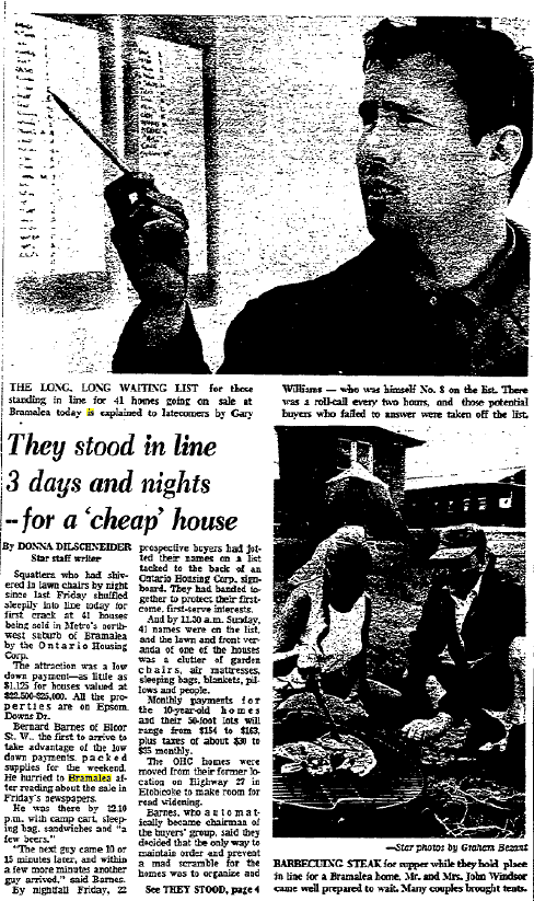
Richview, formally known as Willowridge-Martingrove-Richview, is a neighbourhood in the city of Toronto, Ontario, Canada. It is bounded on the west by Highway 401 and on the north by the highway and by Dixon Road, Royal York Road on the east, and Eglinton Avenue West along the south. Richview was originally established as a postal village within the then-agricultural Etobicoke Township, which later became the suburb of Etobicoke.

Eatonville is a neighbourhood in Toronto, Ontario, Canada. It is located west of the central core, in the former suburb of Etobicoke. Eatonville is bisected by Highway 427, with the community generally located north of Dundas Street West and south of Rathburn Road. Eatonville consists mainly of low density residential homes. The main arterial roads in the community, such as The West Mall, The East Mall and Burnhamthorpe Road, contain a mix of rental and condominium high-rise apartments and townhouses. Cloverdale Mall is in the neighbourhood, and there are community retail areas along Bloor Street West and Dundas Street West.
Markland Wood is a residential neighbourhood in Toronto, Ontario, Canada. It is located west of the central core, in the former suburb of Etobicoke and is the westernmost residential community in Toronto along Bloor Street West. It's located on the border of Mississauga and bounded by Etobicoke Creek to the west, Elmcrest Creek to the east, Burnhamthorpe to the North, and surrounded by the Markland Wood Golf Club; approximately 2/3 is north of Bloor Street, and 1/3 south. Markland Wood is part of the Etobicoke Centre riding for federal and provincial governments and Ward 2 for the municipal council.

Smithfield is a neighbourhood and former village in Toronto, Ontario, Canada. Some new residents of Toronto and new immigrants to Canada are attracted to this neighbourhood, mainly because there is a large amount of affordable public housing. It is named after the former village of Smithfield that was located at the intersection of Albion Road and Martin Grove Road. The neighbourhood is located north of the west branch of the Humber River and west of Kipling Avenue.
Humber Valley Village is a neighbourhood located in Toronto, Ontario, Canada. It is within the former suburb of Etobicoke and includes some of the most expensive real estate in the metropolitan west end. The boundaries are from Dundas Street on the south to Islington Avenue to the west, Eglinton Avenue to the north, and the Humber River in the east. The neighbourhood is in the political riding of Etobicoke Centre.

Humber Heights-Westmount, also known as Humbervale, is a neighbourhood in Toronto, Ontario, Canada. The neighbourhood is bounded by the west bank of the Humber River, west to Royal York Road and south to Eglinton Avenue West. The Humber Creek divides the area into the northern 'Humber Heights' and the southern 'Westmount' centred along Scarlett Road and La Rose Avenue.

Islington-City Centre West is a commercial and residential neighbourhood in Toronto, Ontario, Canada. One of four central business districts outside Downtown Toronto, it is bounded by Rathburn Road to the north, Islington Avenue to the east, Bloor Street to the south, Mimico Creek to the west.

Alderwood is a neighbourhood in the city of Toronto, Ontario, Canada. It is in the western section of Toronto, within the district of Etobicoke. It is bounded by the Etobicoke Creek to the west, the Gardiner Expressway to the north, the CPR railway to the east and the CNR railway to the south.

Woburn is a neighbourhood located in eastern Toronto, Ontario, Canada, in the former suburb of Scarborough. Woburn is bordered by Highway 401 to the north, Orton Park Road to the east, Lawrence Avenue to the south, and McCowan Road to the west.

The Queensway–Humber Bay, known officially as Stonegate–Queensway, is a neighbourhood in the southwest of Toronto, Ontario, Canada. It is located in the southeast area of the former City of Etobicoke.

Princess Gardens is a neighbourhood in Toronto, Ontario, Canada. It is located in the western area of Toronto that was formerly the City of Etobicoke. Its boundaries are Eglinton Avenue to the north, Martin Grove to the west, Islington to the east, and Rathburn Road to the south. The southeastern part of this area is the separate neighbourhood of Thorncrest Village. The neighbourhood is divided into two areas: The portion east of Kipling Road is known as Princess Anne Manor, while the portion west of Kipling is Princess Margaret Gardens. They are named after Princess Anne, Princess Royal, and Princess Margaret, Countess of Snowdon, the daughter and sister of the late Queen Elizabeth II respectively. Both Princesses visited the Gardens and opened up Princess Margaret Public School during its opening ceremony. The southwestern part of the neighbourhood is also sometimes known as Glen Agar. Princess Gardens has some of the highest income Canadians in the Greater Toronto Area according to a 2016 census, at an average of $222,218 per year.

The Etobicoke Board of Education, officially known as the Board of Education for the City of Etobicoke is the former public-secular school board administering the schools of Etobicoke, Ontario, headquartered in the Etobicoke Civic Centre. In 1998, it was merged into the Toronto District School Board. The former EBE offices remain in use today by the TDSB as the West Education Office.


