Toronto Chinatowns are ethnic enclaves in Toronto, Ontario, Canada, with a high concentration of ethnic Chinese residents and businesses. These neighbourhoods are major cultural, social and economic hubs for the Chinese-Canadian communities of the region. In addition to Toronto, several areas in the Greater Toronto Area also hold a high concentration of Chinese residents and businesses.

Parkdale is a neighbourhood and former village in Toronto, Ontario, Canada, west of downtown. The neighbourhood is bounded on the west by Roncesvalles Avenue, on the north by the CP Rail line where it crosses Queen Street and Dundas Street. It is bounded on the east by Dufferin Street from Queen Street south, and on the south by Lake Ontario. The original village incorporated an area north of Queen Street, east of Roncesvalles from Fermanagh east to the main rail lines, today known as part of the Roncesvalles neighbourhood. The village area was roughly one square kilometre in area. The City of Toronto government extends the neighbourhood boundaries to the east, south of the CP Rail lines, east to Atlantic Avenue, as far south as the CN Rail lines north of Exhibition Place, the part south of King Street commonly known as the western half of Liberty Village neighbourhood.

Queen Street is a major east–west thoroughfare in Toronto, Ontario, Canada. It extends from Roncesvalles Avenue and King Street in the west to Victoria Park Avenue in the east. Queen Street was the cartographic baseline for the original east–west avenues of Toronto's and York County's grid pattern of major roads. The western section of Queen is a centre for Canadian broadcasting, music, fashion, performance, and the visual arts. Over the past twenty-five years, Queen West has become an international arts centre and a tourist attraction in Toronto.

Gerrard Street is a street in Toronto, Ontario, Canada. It consists of two separate parts, historically referred to as Lower Gerrard and Upper Gerrard. The former stretches between University Avenue and Coxwell Avenue for 6 km, across Old Toronto. The latter portion starts 300 m north of Lower Gerrard's eastern terminus and runs between Coxwell Avenue and Clonmore Drive, between Victoria Park Avenue and Warden Avenue, in Scarborough for another 4 km.

Liberty Village is a neighbourhood in Toronto, Ontario, Canada. It is bordered to the north by King Street West, to the west by Dufferin Street, to the south by the Gardiner Expressway, to the east by Strachan Avenue, and to the northeast by railway tracks.

Roncesvalles is a neighbourhood in the city of Toronto, Ontario, Canada, centred on Roncesvalles Avenue, a north–south street leading from the intersection of King and Queen Streets to the south, north to Dundas Street West, a distance of roughly 1.7 kilometres. It is located east of High Park, north of Lake Ontario, in the Parkdale–High Park provincial and federal ridings and the municipal Ward 4. Its informal boundaries are High Park to the west, Bloor Street West to the north, Lake Ontario/Queen Street West to the south and Lansdowne Avenue/rail corridor to the east. Originally known as "Howard Park", most of this area was formerly within the boundaries of Parkdale and Brockton villages and was annexed into Toronto in the 1880s.
Commercial Drive is a roadway in the city of Vancouver in British Columbia, Canada, that extends from Powell Street at its northern extremity, near the waterfront, south through the heart of the Grandview–Woodland neighbourhood to the Victoria Diversion near Trout Lake. The neighbourhood is so dominated by the businesses, cultural facilities, and residents along Commercial Drive that the area is far better known as "The Drive" than by the civic boundaries. The district is one of Vancouver's Business Improvement Areas (BIA).
The Punjabi Market, also known as Little India, is a commercial district and ethnic enclave in Vancouver, British Columbia. Officially recognized by the city as being primarily a major South Asian, Indo-Canadian and Punjabi population business community and cultural area, the Punjabi District is roughly a six block section of Main Street around 49th Avenue in the Sunset neighbourhood.
Little India is an Indian or South Asian sociocultural environment outside India or the Indian subcontinent. It especially refers to an area with Indian residences and a diverse collection of Indian businesses. Frequently, Little Indias have Hindu temples, mosques, and gurdwaras. They may also host celebrations of national and religious festivals and serve as gathering places for South Asians. As such, they are microcosms of India. Little Indias are often tourist attractions and are frequented by fans of Indian cuisine, Indian culture, Indian clothing, Indian music, and Indian cinema.

Bloordale Village is a Business Improvement Area (BIA) located along Bloor Street from Dufferin Street to Lansdowne Avenue, west of downtown in Toronto, Ontario, Canada. It sits on the southern border of the Wallace Emerson neighbourhood and the northern border of the Brockton Village neighbourhood. The district is home to various and unique shops including restaurants, bars, vintage and thrift stores.

The cuisine of Toronto reflects Toronto's size and multicultural diversity. Ethnic neighbourhoods throughout the city focus on specific cuisines, such as authentic Chinese and Vietnamese found in the city's Chinatowns, Korean in Koreatown, Greek on The Danforth, Italian cuisine in Little Italy and Corso Italia, Bangladeshi cuisine in southwest Scarborough and East York, and Indian/Pakistani in Little India. Other world cuisines available in the city include Portuguese, Hungarian, Japanese, and Caribbean. Toronto's large Jewish population has given rise to many Jewish restaurants and delis, with varying adherence to kosher rules.
Marda Loop is a shopping and dining district in southwest Calgary, Alberta. While the name "Marda Loop" originated with the BIA, it also applies generically to the surrounding community, and also to the residential Marda Loop Communities Association. This entry is primarily about the Marda Loop BIA.

Corso Italia is a neighbourhood in Toronto, Ontario, Canada, situated on St. Clair Avenue West, between Westmount Avenue and Lansdowne Avenue. It is contained within the larger city-recognized neighbourhood of Corso Italia-Davenport.

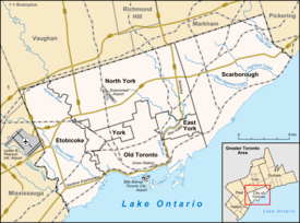
Downtown Toronto is the main central business district of Toronto, Ontario, Canada. Located entirely within the district of Old Toronto, it is approximately 16.6 square kilometres in area, bounded by Bloor Street to the northeast and Dupont Street to the northwest, Lake Ontario to the south, the Don Valley to the east, and Bathurst Street to the west. It is also the home of the municipal government of Toronto and the Government of Ontario.

Downtown Yonge is a retail and entertainment district centred on Yonge Street in Downtown Toronto, Ontario, Canada. The Downtown Yonge district is bounded by Richmond Street to the south; Grosvenor and Alexander Streets to the north; Bay Street to the west; and portions of Church Street, Victoria Street, and Bond Street to the east. All property owners and commercial tenants within these boundaries are members of the Downtown Yonge Business Improvement Area association, founded in 2001.

Bloor West Village is a residential neighbourhood and shopping district in Toronto, Ontario, Canada. Bordered on the south by Bloor Street, it encompasses all businesses along Bloor Street between South Kingsway and Ellis Park Road, consisting of more than 400 shops, restaurants and services, plus the residential neighbourhood to the north. The official City of Toronto name of the neighbourhood is Runneymede-Bloor West Village.

Little Portugal is a neighbourhood and ethnic enclave in Toronto, Ontario, Canada. It is located west of downtown in the "Old" City of Toronto. It is bound on the west by Lansdowne Avenue, on the north by College Street, on the east by Ossington Avenue and on the south by the Go Transit and Union Pearson Express railway tracks. The area is mainly residential, with Portuguese businesses along Dundas Street West and College Street. The area west of Dufferin Street was a part of the former Town of Brockton. The area to the east of Dufferin and south of Dundas Street is also known as "Beaconsfield Village" dating back to the days of the sub-division of lots in the area around Beaconsfield Avenue.
Runnymede is a neighbourhood in Toronto, Ontario, Canada located north of Bloor Street West between Jane Street and Runnymede Road north to Dundas Street West. It is located directly north of the former village of Swansea and west of the High Park North neighbourhood. The immediate area around Bloor Street is commonly known as Bloor West Village after the shopping area along Bloor Street, whereas the area to the north is considered the Runnymede neighbourhood.
Chinatowns in Canada generally exist in the large cities of Vancouver, Ottawa, Calgary, Edmonton, Toronto, and Montreal, and existed in some smaller towns throughout the history of Canada. Prior to 1900, almost all Chinese were located in British Columbia, but have spread throughout Canada thereafter. From 1923 to 1967, immigration from China was suspended due to exclusion laws. In 1997, the handover of Hong Kong to China caused many from there to flee to Canada due to uncertainties. Canada had about 25 Chinatowns across the country between the 1930s to 1940s, some of which have ceased to exist.

Chinatown, Toronto is a Chinese ethnic enclave located in the city's downtown core of Toronto, Ontario, Canada. It is centred at the intersections of Spadina Avenue and Dundas Street West.