New Toronto

Last updated

New Toronto
Neighbourhood
The Assembly Hall.jpg
View of Humber College's Lakeshore Campus near Lake Shore Boulevard
Motto(s): 
Intelligence, Industry, Integrity
Toronto map.png
Red pog.svg
Location within Toronto
Coordinates: 43°36′02″N79°30′19″W / 43.60056°N 79.50528°W / 43.60056; -79.50528
CountryFlag of Canada (Pantone).svg  Canada
ProvinceFlag of Ontario.svg  Ontario
City Toronto
Established1890 (Subdivision)
1892 (Postal village)
Incorporated1913 (Village)
1920 (Town)
Joined1953 Metropolitan Toronto
Government
   MP James Maloney (Etobicoke—Lakeshore))
   MPP Peter Milczyn (Etobicoke—Lakeshore)
   Councillor Mark Grimes (Ward 6 Etobicoke—Lakeshore)

New Toronto is a neighbourhood and former municipality in Toronto, Ontario, Canada. It is located in the south-west area of Toronto, along Lake Ontario. The Town of New Toronto was established in 1890, and was designed and planned as an industrial centre by a group of industrialists from Toronto who had visited Rochester, New York. New Toronto was originally a part of the Township of Etobicoke. It was an independent municipality from 1913 to 1967, being one of the former 'Lakeshore Municipalities' amalgamated into the Borough of Etobicoke, and eventually amalgamated into Toronto. The neighbourhood has retained the name.

Contents

Boundaries

New Toronto is bounded by Lake Ontario to the south, with a western boundary of Twenty Third Street (south of Lake Shore Blvd. West) and the midpoint between Twenty-Second and Twenty-Fourth Streets (north of Lake Shore Blvd. West), the Canadian National Railway mainline to the north, and Dwight Avenue to the east. To the east is the neighbourhood of Mimico and the neighbourhood of Long Branch is to the west. [1] [2] [3]

Character

Colonel Samuel Smith Park runs along the Toronto waterfront, within the Lakeshore Grounds. Lake Ontario. View from Colonel Samuel Smith Park 7.jpg
Colonel Samuel Smith Park runs along the Toronto waterfront, within the Lakeshore Grounds.

New Toronto is now centred around the intersection of Seventh Street/ Islington Avenue and Lake Shore Boulevard West with a commercial strip running east–west along the latter street. Residential streets generally run north–south from Lake Ontario north to Birmingham Street, except for the Lakeshore Grounds (formerly the Mimico Lunatic Asylum / Lakeshore Psychiatric Hospital) to the southwest which extends from Lake Shore Blvd. West south to the Lake. North of Birmingham Street has historically been a large industrial district, although many industries moved or closed in the period from 1987 to 1991.

New Toronto is now a neighbourhood in transition, as the industrial corridor located at the north end of the community is being redeveloped after having been vacant and fallow for many years. Industry that gradually moved out of New Toronto over the years is now being re-established, in addition to institutional uses.

Lakeshore Village, a community of co-operative housing between 9th and 13th Streets, north of Lake Shore Boulevard. West, was built by The Daniels Corp. developers, on the former Goodyear Tire and Rubber Company site. The loss of the former employment base resulted in a considerable downtrend in local business viability, which the lower-income housing could never replace.

In September 2009, the new Toronto Police College training facility opened at 70 Birmingham St., and also houses a 22 Division Police Substation. This is the site of the former Continental Can Company of Canada Ltd. New Toronto Plant.

In 1890, new streets for the Town of New Toronto were laid out in several series, essentially without names by simply using ordinal numbers (First, Second, Third, etc.). When the streets were laid out along Lake Shore Road (now Lake Shore Blvd. West), they had a single new starting point. The second numbering system began with First Street being one half-block west of Dwight Ave (the boundary street between the Town of Mimico and New Toronto) and continuing westward. Originally named "Mimico Avenue", and for most of the 20th century as "Eighteenth Street" (officially, until the 1980s), Kipling Avenue is the westernmost north–south major road. The street-number naming convention was later applied to streets further west of New Toronto in the Village of Long Branch when their streets were renamed in 1931.

History

Establishment

The largest farming families in what would become New Toronto were the Northcote family to the east (south of Lake Shore Blvd. West at Seventh Street/Islington Avenue today), and the Goldthorpe family to the west at Mimico Avenue (now Kipling Avenue), where the Mimico Lunatic Asylum was later built. [4] [5]

In the 1880s, the Goldthorpe farm south of the Lake Shore Road Lake Shore Boulevard West and east of Mimico Avenue was purchased by the Ontario Government. In 1888, it became the location of the Mimico Lunatic Asylum (later known as the Lakeshore Psychiatric Hospital.) It was built to alleviate overcrowding at Toronto's Asylum on Queen Street West (later known as Queen Street Mental Health Centre, and now the Centre for Addiction and Mental Health).

Plans for the subdivision that later developed into New Toronto, 1890. NewTorontoMimicoPlan1890.JPG
Plans for the subdivision that later developed into New Toronto, 1890.

In 1890, a plan of subdivision was filed by a group of industrialists and the first streets laid out for the Town of New Toronto by the Mimico Real Estate Security Company. [6] With the first industries in New Toronto already operating, or to be operational by the end of 1890, New Toronto was promoted with the publication of an article in the edition of October 25, 1890 of the Toronto Globe newspaper (now the Globe & Mail) entitled "Toronto's Growing Suburb – New Toronto – As it is and what it will be". [7] New Toronto, as an industrial centre "was expected to rival – if not exceed – 'old' Toronto in manufacturing output". A few worker's homes were built on early streets north of Lake Shore Road while development proceeded.

New Toronto was planned and designed as a "town", with manufacturing as its focal point, but also including retail business and residential areas in the plan. The Town of New Toronto would become a fully independent, self-sufficient municipality.

John Sheane's Hotel (later, The New Toronto Hotel and the Almont Hotel) was located across from the Asylum grounds at Mimico Avenue (Kipling Ave.) and the Lake Shore Road (now Lake Shore Blvd West). In 1892, a post office was established in New Toronto. The next year, the pastor of Mimico's Methodist Church began holding separate services in New Toronto, establishing a church building as a branch of Mimico's new Methodist Circuit in 1909. [8]

Victorian-era industrial buildings in New Toronto. The area was primarily industrial developments at the beginning of the 20th century. NewTorontoVictorianIndustry.JPG
Victorian-era industrial buildings in New Toronto. The area was primarily industrial developments at the beginning of the 20th century.

The Mimico Yard (the former Grand Trunk Railway freight yard) was established in 1906, encouraging many more industries to relocate to New Toronto. The same year a public school was established on Sixth Street. A proper school house was opened in 1909 on Fifth Street (Fifth Street Public School). [9] By 1911, an Anglican church had been completed in New Toronto called St. Margaret's.

While some early factory housing was built on Sixth Street, and later Fifth Street, little residential development in New Toronto took place until after World War I. Farming was still prevalent south of the Lake Shore Road. Although some realtors began to advertise subdivisions for housing around 1910, it still took at least a decade until a sufficient base of local retail stores existed to support a permanent local population.

Town of New Toronto (1913–1967)

In 1913, New Toronto was incorporated as a separate village, with a population of 500. In 1915 the Methodist church became a separate Methodist Parish from Mimico. 1916 saw a referendum on joining New Toronto to Mimico which passed in Mimico but was defeated by New Toronto residents.

With the First World War raging, new industries arrived in New Toronto - most notably Goodyear Tire and Rubber Company established a plant in 1916-17 which quickly became the town's largest employer. Other major industries included: E.I. du Pont de Nemours and Company 'Fabrikoid' plant (1915, later renamed as "Canadian Industries Limited"), Anaconda American Brass Company of Canada (1922, after taking over the operations of Browns Copper & Brass Rolling Mills Ltd., 1915), Campbell Soup Co. of Canada (1930), W & A Gilbey Ltd. distillery (1933), and the Continental Can Company of Canada Ltd. (1936).

In 1919 Loblaws introduced their "self-shopping" concept with the first Loblaw Groceteria at 2879 Lake Shore Boulevard West in New Toronto. [10]

St. Teresa Catholic Church in 1937. The church was established in New Toronto in 1924. StTheresaRCChurchOldNewToronto.jpg
St. Teresa Catholic Church in 1937. The church was established in New Toronto in 1924.

New Toronto became a fully independent municipality (town) in 1920 and established a Library Association. [11] In 1924 a St. Teresa's Catholic Church was created in New Toronto out of Mimico's St. Leo's Catholic Church.

By 1927 a new school was needed and Seventh Street Public school was opened. [12]

With the creation of the United Church of Canada after the union of the Methodist, Congregational and Presbyterian Churches, the New Toronto Methodist Church opened a new church building, the first to be built specifically as a United Church, called the Century United Church.

The New Toronto fire station was built in 1929, and is still used by Toronto Fire Services. NewTorontoFireStation.JPG
The New Toronto fire station was built in 1929, and is still used by Toronto Fire Services.

In 1929, the New Toronto fire station was built. Designed in an Italianate style, it was also used as the Town Hall for a time. It is still a fire station today. [13] At the same time, the new mayor William Jackson donated land for a Public Library Building. Jackson would go on to be mayor almost continuously until 1952. [14] In 1930, the Campbell Soup Company Ltd. had arrived in New Toronto [15] commissioning architects Mathers and Holdenby to build an Art Deco factory at 60 Birmingham Street (c. 1931). [16] In 1947 the Fifth Street Public School burned down and was replaced with the new Second Street Public School. [17] The former Fifth St. Public School was then rebuilt to become the Town of New Toronto Town Hall.

Because of New Toronto's large industrial base, a new high school was needed to educate and train future workers for industry. In 1951, New Toronto Secondary School (NTSS) was opened. The curriculum of NTSS focused on the sciences and skilled trades (i.e. calculus, functions, geometry, physics, biology, auto mechanics, woodworking, machine shop, electrical shops; to name some of the major study areas).

In 1953 the Town of Mimico, Town of New Toronto, Village of Long Branch, Etobicoke Township, Village of Swansea, Village of Forest Hill, Town of Weston, Town of Leaside, East York Township, North York Township, York Township, Scarborough Township and City of Toronto joined together to create a new common level of government: Metropolitan Toronto (Metro). Each municipality retained its own town council and government, but several infrastructure departments were transferred to Metro. This lasted until 1967, when the number of municipalities in Metro was reduced.

In New Toronto, to serve the large local population of Ukrainians who had settled in the area over the years, St. Michael's Ukrainian Catholic Church was built in 1954 on Sixth Street (just north of St. Margaret's Anglican Church). While many Ukrainian and Polish immigrants lived in New Toronto and surrounding communities beginning early in the 20th century, more arrived after the Communist Bloc collapsed in 1989.

Growing freight traffic in the Toronto area necessitated the creation of an amalgamated facility and a by-pass of the congested Toronto Terminal downtown. In 1965, a new rail freight facility, first named Toronto Yard and then MacMillan Yard, was opened north of Metro Toronto. The local Mimico Railway Yard was downgraded considerably, resulting in the dislocation of much railway employment. At the same time the Toronto By-Pass line allowed for the creation of GO Transit commuter service between Oakville and Pickering. GO named its facility Willowbrook, after the nearby Willowbrook Road. Old CNR facilities in Mimico Yard were used for the startup of this trial train service. Its subsequent growth has resulted in new facilities being built for GO. In 1985, Via Rail facilities at Spadina Avenue were relocated from downtown Toronto to New Toronto's underused former Mimico Yards at the newly completed Toronto Maintenance Centre (which would have its major operations moved to Quebec just a few years later).

Post-annexation (1967–present)

View of residential developments in the former Goodyear Canada site. The property was redeveloped into a residential area after the company closed its operations in New Toronto. NewTorontoResidentialDevelopment.JPG
View of residential developments in the former Goodyear Canada site. The property was redeveloped into a residential area after the company closed its operations in New Toronto.

In 1967, the Town of New Toronto was amalgamated with the other Lake Shore municipalities (Town of Mimico and Village of Long Branch) with Etobicoke to create the new Borough of Etobicoke. Etobicoke later became a city in 1984. In 1998, Etobicoke was amalgamated with the other municipalities of Metropolitan Toronto to form the current City of Toronto.

An upheaval came in May 1987. Goodyear Canada Inc., which was the largest employer in New Toronto, shut down its plant [18] contributing to a general loss of employment in the area. The lands are now the site of several co-operative housing buildings, townhouses, condos, and a park. [19] New Toronto's library branch was demolished in 1993 to be replaced with a new building. [20]

Recent attempts to rejuvenate New Toronto include the protection of remaining industrial lands for employment. The former Mimico Lunatic Asylum buildings and grounds became the new site of Humber College's Lake Shore campus. The new Lakeshore Lions Arena was constructed on the former W & A Gilbey distillery site.

Education

Building G at Humber College's Lakeshore Campus in New Toronto. Humber College G Building (38474491581).jpg
Building G at Humber College's Lakeshore Campus in New Toronto.

New Toronto is also home to Humber College's Lakeshore campus. The college is a public post-secondary institution. The Lakeshore Campus is located on the former grounds of the Mimico Lunatic Asylum (later renamed the Lakeshore Psychiatric Hospital), at the foot of Kipling Avenue (originally Eighteenth Street).

In addition to post-secondary schooling, two public school boards operate institutions within New Toronto, the Toronto District School Board (TDSB), and the Toronto Catholic District School Board (TCDSB). Both school boards provide primary and secondary schooling.

Father John Redmond Catholic Secondary School and Regional Arts Centre is a major public separate secondary school serving this neighbourhood. Father John Redmond Catholic Secondary School.jpg
Father John Redmond Catholic Secondary School and Regional Arts Centre is a major public separate secondary school serving this neighbourhood.

TDSB is a secular public school board for the city, and operates one secondary school in the neighbourhood, Lakeshore Collegiate Institute, originally New Toronto Secondary School. The secondary school opened in 1951. Its purpose was to provide technical education to students who would either go on to university or enter the skilled trades, as the school's focus was on technical shops and science education, whereas Mimico High School was business-oriented. The Lakeshore district experienced a constant heightened demand for skilled trades due to the numerous major industries and supporting businesses located there. New Toronto Secondary School was expanded in 1965 to accommodate a growing student population. The school merged with Alderwood Collegiate Institute to form Lakeshore Collegiate Institute in 1983, due to falling public school enrollment when the Province extended public funding to Catholic high schools. New Toronto's building was designed by architect John B. Parkin.

Lakeshore Collegiate Institute is a public secondary school located in the neighbourhood. Lakeshore Collegiate Institute.jpg
Lakeshore Collegiate Institute is a public secondary school located in the neighbourhood.

TDSB operates several elementary and middle schools in New Toronto. They include:

TCDSB is a public separate school board for the city, and operates one elementary school in the neighbourhood, St. Teresa Catholic Elementary School. Located on Tenth Street. Prior to its establishment, children attending Catholic schools went to Christ the King Catholic School or St. Leo Catholic Elementary School. St. Teresa's school was established in 1957 during a post war population boom in the, then independent, Town of New Toronto, including many families from predominantly Catholic countries, especially Poland.

Demographics

In 2016, the New Toronto neighbourhood was home to 11,463 residents. [21] 66% of the population speak English as their first language, 5.2% speak Polish, 2.9% speak Tagalog and 2.5% speak Spanish.

Major ethnic populations (2016):

Institutions

The New Toronto branch of the Toronto Public Library operates within the neighbourhood. New Toronto TPL.jpg
The New Toronto branch of the Toronto Public Library operates within the neighbourhood.

New Toronto always had a large industrial base including plants operated by: Ritchie and Ramsay Co. paper mills, Anaconda American Brass Ltd., Canadian Industries Ltd., Goodyear Tire and Rubber Co. Ltd., Plibrico, Charis Ltd., W & A Gilbey Ltd., Continental Can Company of Canada Ltd. (all demolished), as well as the Campbell Soup Company of Canada Ltd. and Dominion Colour Corporation Ltd. (surviving), McDonald Stamping Works/Robert Menzie Wallpaper Co./Reg. N. Boxer Co./Canadian Wallpaper Manufacturers Ltd., Mel-O-Ripe Bananas (buildings survive).

Churches

  • St. Margaret Anglican Church (est. 1906)
  • St. Teresa Roman Catholic Church (est. 1924)
  • St. Michaels Ukrainian Catholic Church (est. 1954)
  • Living Hope Baptist Church
  • New Covenant Pentecostal Church
  • Bosnian Mosque, former site of Century United Church

Transportation

The Toronto Transit Commission's 501 Queen streetcar line, which runs along Lake Shore Boulevard, connects New Toronto to the downtown core. Though Mimico GO Station is nearby and GO Transit trains use track in the northern reaches of the neighbourhood, there is no active railway station in New Toronto. Four TTC bus lines serve the area. The 44 Kipling South, [24] the 110 Islington South [25] and the 944 Kipling South Express [26] routes connect to the Bloor-Danforth subway to the north.

Notable people

Mayors

The building that housed the former New Toronto Town Hall. NewTorontoFormerTownHall.JPG
The building that housed the former New Toronto Town Hall.

The position of Mayor of the Town of New Toronto was created in 1920. [27] The town also retained the position of reeve, as the municipality's second ranking position, until 1954 and had a deputy reeve from 1921 to 1953. [27]

Mayors of New Toronto include:

See also

Related Research Articles

<span class="mw-page-title-main">Etobicoke</span> District of Toronto, Ontario, Canada

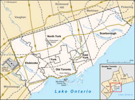
Etobicoke is an administrative district and former city within Toronto, Ontario, Canada. Comprising the city's west-end, Etobicoke is bordered on the south by Lake Ontario, on the east by the Humber River, on the west by Etobicoke Creek, the cities of Brampton, and Mississauga, the Toronto Pearson International Airport, and on the north by the city of Vaughan at Steeles Avenue West.

<span class="mw-page-title-main">Mimico</span> Neighbourhood in Toronto, Ontario, Canada

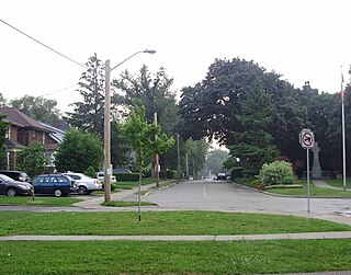
Mimico is a neighbourhood in Toronto, Ontario, Canada, being located in the south-west area of Toronto on Lake Ontario. It is in the south-east corner of the former Township of Etobicoke, and was an independent municipality from 1911 to 1967.

<span class="mw-page-title-main">Etobicoke—Lakeshore (federal electoral district)</span> Federal electoral district in Ontario, Canada

Etobicoke—Lakeshore is a federal electoral district in Ontario, Canada, that has been represented in the House of Commons of Canada since 1968.

<span class="mw-page-title-main">Lake Shore Boulevard</span> Street in Toronto

Lake Shore Boulevard is a major arterial road running along more than half of the Lake Ontario waterfront in the city of Toronto, Ontario, Canada. Prior to 1998, two segments of Lake Shore Boulevard were designated as part of Highway 2, with the highway following the Gardiner Expressway between these two sections.

<span class="mw-page-title-main">Kipling Avenue</span> Road in Toronto, Canada

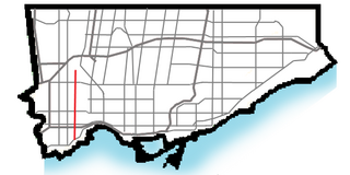
Kipling Avenue is a street in the cities of Toronto and Vaughan in Ontario, Canada. It is a concession road, 6 concessions (12 km) west from Yonge Street, and is a major north–south arterial road. It consists of three separate sections, with total combined length of 26.4 km. (16.4 mi.).

<span class="mw-page-title-main">Mimico GO Station</span> Railway station in Toronto, Ontario, Canada

Mimico GO Station is a railway station in the GO Transit network located in the Etobicoke area of Toronto, Ontario, Canada. It is a stop on the Lakeshore West line train service, serving the Mimico neighbourhood.

<span class="mw-page-title-main">Richview, Toronto</span> Neighbourhood in Toronto, Ontario, Canada

Richview, formally known as Willowridge-Martingrove-Richview, is a neighbourhood in the city of Toronto, Ontario, Canada. It is bounded on the west by Highway 401 and on the north by the highway and by Dixon Road, Royal York Road on the east, and Eglinton Avenue West along the south. Richview was originally established as a postal village within the then-agricultural Etobicoke Township, which later became the suburb of Etobicoke.

<span class="mw-page-title-main">Toronto and Mimico Electric Railway and Light Company</span> Former operator of the Mimico radial line in Toronto

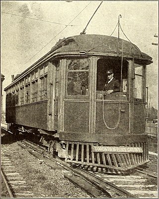
The Toronto and Mimico Electric Railway and Light Company was incorporated in 1890, and operated the Mimico radial line in the Toronto area. The line started operation in 1892 as a short suburban line that later was extended to Port Credit. In 1904, the railway was acquired by the Toronto and York Radial Railway (T&YRR) and became the T&YRR Mimico Division. In 1922, the City of Toronto acquired the T&YRR and contracted Ontario Hydro to manage the four T&YRR lines including the Mimico line. In 1927, the TTC took over the operation of the Mimico line and extended its service eastward to Roncesvalles Avenue. In 1928, the TTC double-tracked the line from Humber to Long Branch and made that portion part of the Lake Shore streetcar line. The portion beyond Long Branch to Port Credit became the Port Credit line, and continued operation as a single-track radial line until its closure on February 9, 1935.

<span class="mw-page-title-main">Smithfield, Toronto</span> Part of a neighbourhood in Toronto, Ontario, Canada

Smithfield is a neighbourhood and former village in Toronto, Ontario, Canada. Some new residents of Toronto and new immigrants to Canada are attracted to this neighbourhood, mainly because there is a large amount of affordable public housing. It is named after the former village of Smithfield that was located at the intersection of Albion Road and Martin Grove Road. The neighbourhood is located north of the west branch of the Humber River and west of Kipling Avenue.

<span class="mw-page-title-main">Islington-City Centre West</span> Neighbourhood in Toronto, Ontario, Canada

Islington-City Centre West is a commercial and residential neighbourhood in Toronto, Ontario, Canada. One of four central business districts outside Downtown Toronto, it is bounded by Rathburn Road to the north, Islington Avenue to the east, Bloor Street to the south, Mimico Creek to the west.

<span class="mw-page-title-main">Humber Bay</span>

Humber Bay is a bay of Lake Ontario south of Toronto, Ontario, Canada. It is located between Ontario Place on the east and Mimico Creek to the west. The bay gives its name to Etobicoke's Humber Bay neighbourhood.

<span class="mw-page-title-main">The Queensway–Humber Bay</span> Neighbourhood in Toronto, Ontario, Canada

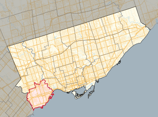
The Queensway–Humber Bay, known officially as Stonegate–Queensway, is a neighbourhood in the southwest of Toronto, Ontario, Canada. It is located in the southeast area of the former City of Etobicoke.

<span class="mw-page-title-main">Lakeshore Collegiate Institute</span> Public high school in Toronto, Ontario, Canada

Lakeshore Collegiate Institute is a high school in Toronto, Ontario, Canada. Built in 1951, Lakeshore Collegiate is a merger of New Toronto Secondary School and Alderwood Collegiate Institute. It is situated on the northwest corner of Kipling Avenue and Birmingham Street in Ward 3 of the Toronto District School Board. It serves the New Toronto, Long Branch, Alderwood, and Mimico neighbourhoods.

<span class="mw-page-title-main">Princess Gardens</span> Neighbourhood in Toronto, Ontario, Canada

Princess Gardens is a neighbourhood in Toronto, Ontario, Canada. It is located in the western area of Toronto that was formerly the City of Etobicoke. Its boundaries are Eglinton Avenue to the north, Martin Grove to the west, Islington to the east, and Rathburn Road to the south. The southeastern part of this area is the separate neighbourhood of Thorncrest Village. The neighbourhood is divided into two areas: The portion east of Kipling Road is known as Princess Anne Manor, while the portion west of Kipling is Princess Margaret Gardens. They are named after Princess Anne, Princess Royal, and Princess Margaret, Countess of Snowdon, the daughter and sister of the late Queen Elizabeth II respectively. Both Princesses visited the Gardens and opened up Princess Margaret Public School during its opening ceremony. The southwestern part of the neighbourhood is also sometimes known as Glen Agar. Princess Gardens has some of the highest income Canadians in the Greater Toronto Area according to a 2016 census, at an average of $222,218 per year.

<span class="mw-page-title-main">Royal York Road</span> Thoroughfare in Toronto, Ontario

Royal York Road, historically known as Church Street or New Church Street, is a north-south arterial road in Toronto, Ontario, Canada. It is a concession road, 5 concessions (10 km) west of Yonge Street, and runs through many residential neighbourhoods, most notably Mimico and the Kingsway. It is classified as a "minor arterial" road by the city of Toronto.

<span class="mw-page-title-main">Long Branch, Toronto</span> Neighbourhood in Toronto, Ontario, Canada

Long Branch is a neighbourhood and former municipality in the south-west of Toronto, Ontario, Canada. It is located in the south-western corner of the former Township of Etobicoke on the shore of Lake Ontario. The Village of Long Branch was a partially independent municipality from 1930 to 1967. Long Branch is located within a land grant from the government to Colonel Samuel Smith in the late 18th century. After Smith's death, a small portion of it was developed as a summer resort in the late 1800s.

<span class="mw-page-title-main">St. Leo's Roman Catholic Church (Mimico)</span> Church in Toronto, Ontario

St. Leo's Roman Catholic Church is a Catholic church in Toronto, Ontario, Canada. It is located on Royal York Road at Stanley, in the Mimico neighbourhood, part of Etobicoke. It is the oldest Catholic church in Etobicoke and the only Catholic church in Mimico.

<span class="mw-page-title-main">Mimico Centennial Library</span>

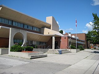
Mimico Centennial Library is a public library in Toronto, Ontario, Canada. It is a branch of the Toronto Public Library system and is located in the neighbourhood of Mimico in the former city of Etobicoke.

<span class="mw-page-title-main">New Toronto Secondary School</span> Public high school in Toronto, Ontario, Canada

New Toronto Secondary School, formerly known as Long Branch Continuation School and New Toronto Vocational School is a former public high school in Toronto, Ontario, Canada. It existed from 1926 until 1983 in the old town of New Toronto and later the suburb of Etobicoke. This school was operated by the New Toronto Board of Education, which was then merged into the Etobicoke Board of Education and the Toronto District School Board.

<span class="mw-page-title-main">Lakeshore Road</span> Road in Ontario, Canada

Lakeshore Road is a historic roadway in the Canadian province of Ontario, running through the city of Burlington and the town of Oakville in Halton Region, as well as the city of Mississauga in Peel Region. As its name implies, the road closely follows the shoreline of Lake Ontario, although the lake itself is not visible from the road in most areas. Lakeshore Road was once a key section of the historic Highway 2, which traversed the province, but has since been downloaded to local municipalities. Despite this historical role as a major route, however, most of the road is a lower-capacity picturesque residential and historic commercial street with only two through lanes until it becomes a four-lane, higher-volume artery after it enters Mississauga and jogs to the north.

References

  1. "Home". www.newtorontohistorical.com. Retrieved April 12, 2018.
  2. "City of Toronto, Urban Development Services West District, map, Etobicoke Zoning New Toronto East (April 2003)" (PDF).
  3. "City of Toronto, Urban Development Services West District, map, Etobicoke Zoning New Toronto West, (December 2004)" (PDF). City of Toronto.
  4. Tremaines Atlas of the County of York, 1860
  5. Illustrated Historical Atlas of the County of York 1878, Etobicoke Township
  6. Mimico, Etobicoke Township, York County, Province of Ontario, Chas. E. GOAD, 1890
  7. "Early History". www.newtorontohistorical.com. Archived from the original on January 20, 2009.
  8. Religion Archived May 25, 2011, at the Wayback Machine . Newtorontohistorical.com. Retrieved on July 26, 2013.
  9. Education – Fifth Street Public School Archived January 24, 2020, at the Wayback Machine . Newtorontohistorical.com. Retrieved on July 26, 2013.
  10. Harris, Denise (October 29, 2015). "New Toronto's Loblaw Groceteria introduced self-shopping in 1919". Etobicoke Guardian. Retrieved January 14, 2016.
  11. "New Toronto Public Library". Newtorontohistorical.com. February 9, 1923. Archived from the original on February 20, 2012. Retrieved July 26, 2013.
  12. Education – Seventh Street Public School Archived September 5, 2019, at the Wayback Machine . Newtorontohistorical.com. Retrieved on July 26, 2013.
  13. New Toronto Fire Department Archived July 10, 2004, at the Wayback Machine . Newtorontohistorical.com (December 31, 1954). Retrieved on 2013-07-26.
  14. "Archived copy" (PDF). www.newtorontohistorical.com. Archived from the original (PDF) on October 23, 2007. Retrieved January 17, 2022.{{cite web}}: CS1 maint: archived copy as title (link)
  15. Campbell’s Soup Archived February 4, 2018, at the Wayback Machine , Newtorontohistorical.com. Retrieved on July 26, 2013.
  16. Harris, Denise (February 12, 2015). "ETOBICOKE HISTORY CORNER: Photo of boy inspires stories of Baycroft family and Campbell's Soup plant". insidetoronto.com. Retrieved April 12, 2018.
  17. Second Street J Archived February 4, 2018, at the Wayback Machine . Newtorontohistorical.com. Retrieved on July 26, 2013.
  18. "Goodyear Tire & Rubber". Newtorontohistorical.com. Archived from the original on September 11, 2013. Retrieved July 26, 2013.
  19. Pasold, Lisa (May 1, 2009). "Habitats: New Toronto". blogTo.
  20. New Toronto : Toronto Public Library. Torontopubliclibrary.ca. Retrieved on July 26, 2013.
  21. "New Toronto neighbourhood profile" (PDF). City of Toronto. Retrieved November 21, 2018.
  22. New Toronto Post Office. Newtorontohistorical.com (August 31, 1936). Retrieved on 2013-07-26.
  23. Almont Hotel. Newtorontohistorical.com. Retrieved on July 26, 2013.
  24. "TTC Description of 44 Kipling South". ttc.ca. Retrieved April 12, 2018.
  25. "TTC Description of 110 Islington South". ttc.ca. Retrieved April 12, 2018.
  26. "TTC Description of 944 Kipling South Express". ttc.ca. Retrieved April 6, 2019.
  27. 1 2 "New Toronto's Politicians". New Toronto Historical. Archived from the original on August 14, 2018.
  28. "Mayors and Reeves of Etobicoke (1850 - 1998)". Etobicoke Historical Society. Retrieved September 21, 2020.
  29. Mayor William Jackson: Dies in Office Day Following 9th Acclamation The Globe and Mail (1936-2016); Toronto, Ont. [Toronto, Ont]26 Nov 1951: 10.
  30. John L. Strath: Former Mayor Of New Toronto The Globe and Mail (1936-2016); Toronto, Ont. [Toronto, Ont]06 Sep 1955: 5.
  31. Ex-New Toronto Mayor John L. Strath, 67, Dies, Toronto Daily Star (1900-1971); Toronto, Ontario [Toronto, Ontario]06 Sep 1955: 16.
  32. "Residents". Archived from the original on March 4, 2008. Retrieved September 30, 2009.