The Frederick G. Gardiner Expressway, commonly known as the Gardiner Expressway or simply the Gardiner, is a partially at grade and elevated municipal expressway in Toronto, Ontario, Canada. Running close to the shore of Lake Ontario, it extends from the foot of the Don Valley Parkway (DVP) in the east, just past the mouth of the Don River, to the junction of Highway 427 and the Queen Elizabeth Way (QEW) in the west, for a total length of 18.0 kilometres (11.2 mi). East of Dufferin Street to just east of the Don River, the roadway is elevated for a length of 6.8 kilometres (4.2 mi), unofficially making it the longest bridge in Ontario. It runs above Lake Shore Boulevard east of Spadina Avenue.

Harbourfront is a neighbourhood on the northern shore of Lake Ontario within the downtown core of the city of Toronto, Ontario, Canada. Part of the Toronto waterfront, Harbourfront extends from Bathurst Street in the west, along Queens Quay, with its ill-defined eastern boundary being either Yonge Street or York Street. Its northern boundary is the Gardiner Expressway. Much of the district was former water lots filled in during the early 1900s to create a larger harbour district. After shipping patterns changed and the use of the Toronto harbour declined, the area was converted from industrial uses to a mixed-use district that is mostly residential and leisure.

The Toronto waterfront is the lakeshore of Lake Ontario in the city of Toronto, Ontario, Canada. It spans 46 kilometres between the mouth of Etobicoke Creek in the west and the Rouge River in the east.

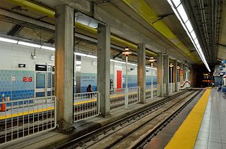
Union is a subway station on Line 1 Yonge–University of the Toronto subway in Toronto, Ontario, Canada. It opened in 1954 as one of twelve original stations on the first phase of the Yonge line, the first rapid transit line in Canada. It was the southern terminus of the line until the opening of the University line in 1963, and is today the inflection point of the U-shaped line. Along with Spadina station, it is one of two stations open overnight to support late-night streetcar routes.

Lake Shore Boulevard is a major arterial road running along more than half of the Lake Ontario waterfront in the city of Toronto, Ontario, Canada. Prior to 1998, two segments of Lake Shore Boulevard were designated as part of Highway 2, with the highway following the Gardiner Expressway between these two sections.
Queens Quay is a prominent street in the Harbourfront neighbourhood of Toronto, Ontario, Canada. The street was originally commercial in nature due to the many working piers along the waterfront; parts of it have been extensively rebuilt in since the 1970s with parks, condominiums, retail, as well as institutional and cultural development.
Queens Quay is an underground streetcar station of the Toronto streetcar system in Toronto, Ontario, Canada. It is the only underground streetcar station that is not part of or connected to a Toronto subway station. It was opened in 1990 as part of the former Harbourfront LRT route. The station is now served by the 509 Harbourfront, 510 Spadina daytime routes and the 310 Spadina night route.
Moss Park is a residential neighbourhood located in downtown Toronto, Ontario, Canada. The area known as Moss Park is typically considered to be between Jarvis Street and Parliament Street, south of Dundas Street, an area dominated by public housing projects. According to one set of boundaries of the City of Toronto, it is roughly L-shaped, bounded on the north by Carlton Street to Parliament Street, on the east by Parliament Street to Queen Street East and the Don River, on the south by Eastern Avenue and Front Street, and on the west by Jarvis Street. This larger concept of the area includes the neighbourhoods known as Corktown and the Garden District, as well as a portion of Cabbagetown.

The Port Lands of Toronto, Ontario, Canada are an industrial and recreational neighbourhood located about 5 kilometres south-east of downtown, located on the former Don River delta and most of Ashbridge's Bay.
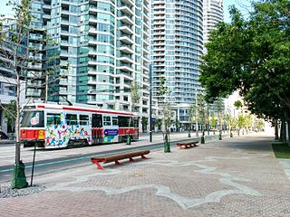
The Waterfront West LRT (WWLRT) is a proposed streetcar line in Toronto, Ontario, Canada. The WWLRT is currently part of a City project called the Waterfront Transit Reset which also includes the East Bayfront LRT. The WWLRT was initially proposed as part of the Transit City plan to expand transit services offered by the Toronto Transit Commission that was announced March 16, 2007. The new line was to use existing parts of the Toronto streetcar system, extending from Union station to Long Branch Loop via Exhibition Place.
Waterfront Toronto is an organization that oversees revitalization projects along the Toronto waterfront. Established in 2001 as a public–public partnership between the City of Toronto, Province of Ontario and Government of Canada, the organization is administering several blocks of land redevelopment projects surrounding Toronto Harbour and various other initiatives to promote the revitalization of the area, including public transit, housing developments, brownfield rehabilitation, possible removal of the Gardiner Expressway in the area, the Martin Goodman Trail and lakeshore improvements, and naturalization of the Don River. Actual development of the projects is done by other entities, primarily private corporations. The projects include a series of wavedeck walkways and gathering places designed by West 8 and DTAH.

Jarvis Street is a north-south thoroughfare in downtown Toronto, Ontario, Canada, passing through some of the oldest developed areas in the city. Its alignment extends from Queens Quay East in the south to Bloor Street in the north. The segment south of Front Street is known as "Lower Jarvis Street" while the segment from Bloor Street to Mount Pleasant Road is known as "Ted Rogers Way".

Corus Quay, originally named First Waterfront Place, is an eight-storey commercial office tower located on a 2.5-acre (1.0 ha) waterfront site in Toronto, Ontario, Canada. The CA$160 million building is the first major development planned for the East Bayfront district, and completed construction at the foot of Jarvis Street or Jarvis Street Slip. Corus Quay is Corus Entertainment's new Toronto headquarters, consolidating its 10 locations and 1,200 employees into one site. The building was designed by Diamond Schmitt Architects with interiors completed by Quadrangle Architects. The building was being developed by the Toronto Economic Development Corporation (TEDCO), a city agency. Funding for the project came from TEDCO's equity, city loans and a CA$12.5 million contribution from the city contributed via Waterfront Toronto.

Fort York, also known as Garrison, is a neighbourhood in Toronto, Ontario, Canada, located west of Downtown Toronto, north of Billy Bishop Toronto City Airport, and east of Exhibition Place along the shores of Lake Ontario. While it is home to Fort York, a National Historic Site, it also contains several mid and high-rise condominium buildings built during the 21st century.

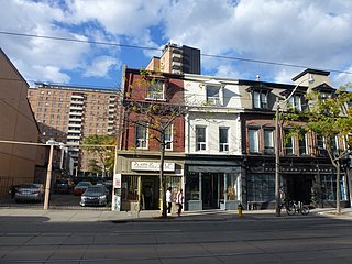
Old Town is a neighbourhood and retail district in downtown Toronto, Ontario, Canada. It was the first of Toronto's named neighbourhoods, having acquired the moniker no later than 1815, at which time the original town of York was expanding. The old neighbourhood was referred to as "Old Town" by residents, and the new neighbourhood as "New Town". The site still has many buildings dating back to the nineteenth century.

Sugar Beach is an urban beach park in Toronto, Ontario, Canada, that opened in 2010. It is located across from Redpath Sugar Refinery in Toronto's eastern East Bayfront. Like HTO Park to the west, the beach is not meant to allow wading or swimming in Lake Ontario, but rather functions as a waterfront public space for relaxation, leisure, and social activities. It cost $14 million.
East Bayfront LRT is a proposed Toronto streetcar line that would serve the East Bayfront and Port Lands areas in Toronto, Ontario, Canada. It would run from Union station under Bay Street and along Queens Quay and Cherry Street to a new Polson Loop near the intersection of Cherry and Polson Streets in the Port Lands. It would complement the existing 509 Harbourfront service which connects Union Station to Queens Quay west of Bay Street. Longer term plans are to extend the East Bayfront line from Cherry and Commissioners Streets to the proposed East Harbour station along the planned Ontario Line.
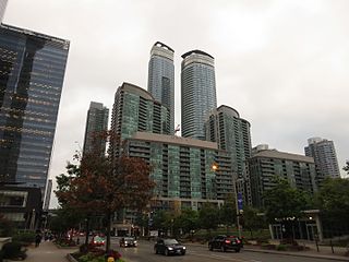
South Core is a neighbourhood located in downtown Toronto, Ontario, Canada. The South Core occupies the eastern portions of the Railway Lands. The remodeling and restoration of Union Station and the construction of a new wave of business and condominium towers is central to this area's forecast growth.
"Forecasters expect the downtown population to grow 80 per cent to 130,000 by 2031. With the financial district just to the north and the new high-rise South Core on the other side, Union is right at the centre."

Quayside is a waterfront district slated for redevelopment in Toronto, Ontario, Canada. Formerly dockland and industrial uses, The Waterfront Toronto government agency intends for a new housing development to be built between the East Bayfront and Port Lands neighbourhoods, a site of 4.9 hectares of land. A smart city project was in the planning stages, proposed by Sidewalk Labs, a subsidiary of Alphabet Inc., named Sidewalk Toronto. Alphabet announced the cancellation of the project on May 7, 2020. Development of the site is now on hold.
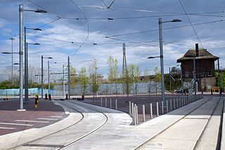
Distillery Loop is a streetcar loop in the Toronto streetcar system in Toronto, Ontario, Canada that lies at the south end of the Cherry Street branch – originally dubbed the Cherry Street streetcar line – that runs from a streetcar junction on King Street East south along Sumach and Cherry Streets. The loop opened in June 2016 and is some of the newer streetcar infrastructure in the city. The Cherry Street branch is currently served by the 504A King streetcar route which has its eastern terminus at Distillery Loop.


