
The Queensway, is a major street in the municipalities of Toronto and Mississauga, Ontario, Canada. It is a western continuation of Queen Street, after it crosses Roncesvalles Avenue and King Street in Toronto. The Queensway is a divided roadway from Roncevalles westerly until 600 metres of the South Kingsway with its centre median dedicated to streetcar service. The road continues undivided west from there to Etobicoke Creek as a four- or six-lane thoroughfare.
The Queen Street subway line was a proposed subway line for the city of Toronto, Ontario, Canada. It was one of many subway lines planned for, but has yet to be built by the Toronto Transit Commission.

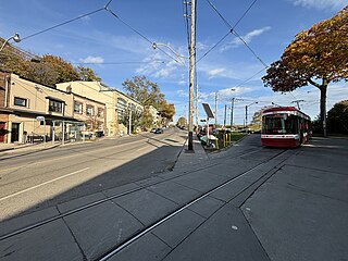
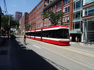
The Toronto streetcar system is a network of eleven streetcar routes in Toronto, Ontario, Canada, operated by the Toronto Transit Commission (TTC). It is the third busiest light-rail system in North America. The network is concentrated primarily in Downtown Toronto and in proximity to the city's waterfront. Much of the streetcar route network dates from the 19th century. Three streetcar routes operate in their own right-of-way, one in a partial right-of-way, and six operate on street trackage shared with vehicular traffic with streetcars stopping on demand at frequent stops like buses. Since 2019, the network has used low-floor streetcars, making it fully accessible.

The 512 St. Clair is an east–west streetcar route in Toronto, Ontario, Canada, operated by the Toronto Transit Commission (TTC). It operates on St. Clair Avenue between St. Clair station on the Line 1 Yonge–University subway and Gunns Road, just west of Keele Street.

501 Queen is an east–west Toronto streetcar route in Ontario, Canada, operated by the Toronto Transit Commission (TTC). It stretches from Neville Park Loop in the east, running along Queen Street and in a reserved right-of-way within the median of the Queensway to Humber Loop in the west. In the late evenings, the 501 Queen route is extended west from Humber Loop, running on Lake Shore Boulevard to Long Branch Loop, replacing route 507 Long Branch. This route operates as part of the TTC's Blue Night Network service, operating in the early morning hours as the 301 Queen.

The 511 Bathurst is a Toronto streetcar route operated by the Toronto Transit Commission in Ontario, Canada.

504 King is an east–west Toronto streetcar route in Ontario, Canada. It serves King Street in Downtown Toronto as well as Broadview Avenue on the east end and Roncesvalles Avenue on the west end of the line. The route consists of two overlapping branches: 504A between Line 2 Bloor–Danforth's Dundas West station and Distillery Loop, and 504B between Broadview station – also on Line 2 – and Dufferin Gate Loop. The two branches overlap on King Street between Dufferin and Sumach streets, both passing St. Andrew station and King station on subway Line 1 Yonge–University.

The 508 Lake Shore is an east–west streetcar route in Toronto, Ontario, Canada, operated by the Toronto Transit Commission (TTC). The route serves the downtown financial district from the western limit of the city, and operated as a weekday rush hour service only. The route was started as an experiment in 1992, suspended in June 2015 due to a streetcar shortage, and reintroduced in September 2019. It was suspended again on March 24, 2020, due to low ridership during the COVID-19 pandemic. Effective October 30, 2023, 508 Lake Shore service resumed after completion of infrastructure work west of Roncesvalles Avenue.

506 Carlton is a Toronto streetcar route run by the Toronto Transit Commission in Ontario, Canada. It runs from Main Street station on subway Line 2 Bloor–Danforth along Gerrard, Carlton and College Streets to High Park. Despite the route's name, less than 10 percent of its length actually uses Carlton Street.

The 505 Dundas is a Toronto streetcar route run by the Toronto Transit Commission in Ontario, Canada. The route is roughly U-shaped running mainly along Dundas Street between Dundas West and Broadview stations several blocks south of the Line 2 Bloor–Danforth subway.

The 502 Downtowner was a streetcar route operated by the Toronto Transit Commission in Toronto, Ontario, Canada. It ran from the Bingham Loop at Victoria Park Avenue and Kingston Road in the Beaches neighbourhood to McCaul Loop in downtown Toronto. Starting in September 2019, all streetcar services along Kingston Road were consolidated into the 503 Kingston Rd route.
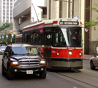
The 503 Kingston Rd is an east–west Toronto streetcar route in Ontario, Canada, operated by the Toronto Transit Commission. The 503 Kingston Rd travels on a route to the downtown financial district from the Bingham Loop along Kingston Road and shares much of its track with the 501 Queen and 504 King. Originally a rush-hour service, the route was upgraded in September 2019 to run weekdays excluding evenings after the consolidation of 502 Downtowner service into this route. Effective July 30, 2023, route 503 started running all day and all evening, seven days per week.

Grange Park is a neighbourhood in downtown Toronto, Ontario, Canada. It is bounded on the west by Spadina Avenue, on the north by College Street, on the east by University Avenue and on the south by Queen Street West. It is within the 'Kensington-Chinatown' planning neighbourhood of the City of Toronto. Its name is derived from the Grange Park public park. The commercial businesses of Chinatown extend within this neighbourhood.

Turning loops of the Toronto streetcar system serve as termini and turnback points for streetcar routes in Toronto, Ontario, Canada. The single-ended streetcars require track loops in order to reverse direction. Besides short off-street track loops these can also be larger interchange points, having shelters and driver facilities, or be part of a subway station structure for convenient passenger interchange.
Neville Park Loop is the eastern terminus of the 301/501 Queen streetcar line, the longest streetcar route of the Toronto Transit Commission (TTC). It is also the terminus of the 143 Beaches/Downtown express bus service. It is located at the southwest corner of Queen Street East and Nursewood Road in the Beaches neighbourhood of Toronto. It is named after the street which is just west of the loop.
Humber Loop is a multimodal transit station and a hub for streetcar routes. It consists of two streetcar turning loops and one bus loop. Humber Loop is located between the Gardiner Expressway and the Queensway just west of the Humber River in Toronto. The loop is accessed by a private right-of-way along the Queensway on the east side of the loop and by Lake Shore Boulevard on its west side. As of November 19, 2023, four Toronto Transit Commission (TTC) streetcar routes either pass through or terminate at Humber Loop.

Dufferin Gate Loop, also known as Dufferin Loop, is a Toronto Transit Commission (TTC) bus station and turning loop for streetcars near the southern end of Dufferin Street in Toronto, Ontario, Canada. During the Canadian National Exhibition (CNE), the loop becomes a primary access point for visitors entering Exhibition Place via the Dufferin Gates. This west entrance to the CNE can be reached by the Dufferin Street bridges across the Lakeshore West railway corridor and Gardiner Expressway.

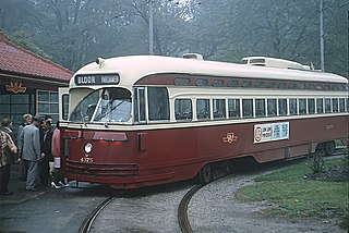
The Toronto Transit Commission operated the Bloor streetcar line along Bloor Street and Danforth Avenue, extending at its longest from Jane Street in the west end of the city to Luttrell Avenue in the east. Both Luttrell and Jane loops at the termini were transfer points between streetcars and suburban bus routes. The line was abandoned in 1966 with the opening of the Bloor-Danforth subway line, except for two stubs of the line abandoned in 1968.
The 514 Cherry was a streetcar route of the Toronto streetcar system in Toronto, Ontario, Canada, that operated from June 19, 2016, until October 7, 2018. The 514 operated through the financial district and downtown Toronto between Dufferin Gate Loop and the Distillery Loop. It used to supplement with the 504 King service along King Street, specifically to the dense residential areas in Liberty Village, the Canary District and the Distillery District. The City of Toronto's "King Street Visioning Study" proposed a transit and pedestrian corridor through which this route would operate.
Various organizations operated streetcars on Parliament Street, in Toronto, Ontario. The Toronto Transit Commission (TTC) discontinued scheduled service on Parliament in 1966, when it opened the Bloor-Danforth subway.

