Hob (folklore)

Last updated
Runswick Bay, North Yorkshire. Local people would ask "Hobhole Hob" for help to get rid of a cough. (Whitby, Runswick Bay, Yorkshire, England) (LOC) (16616684149).jpg
Runswick Bay, North Yorkshire. Local people would ask "Hobhole Hob" for help to get rid of a cough.

A hob is a type of small mythological household spirit found in the English Midlands, Northern England, [lower-alpha 1] [lower-alpha 2] and on the Anglo-Scottish border, according to traditional folklore of those regions. [3] They could live inside the house or outdoors. They are said to work in farmyards and thus could be helpful; however, if offended they could become nuisances. The usual way to dispose of a hob was to give them a set of new clothing, the receiving of which would make the creature leave forever. It could, however, be impossible to get rid of the worst hobs. [4]

Contents

Etymology

"Hob" is a diminutive form of the name "Robin", which is itself a diminutive form of the name "Robert". [5]

"Hob" is sometimes a generic term given to a goblin, bogle or brownie. The name "Hob" became associated with the mythical creature as "a piece of rude familiarity to cover up uncertainty or fear"; [6] essentially, calling a mystical creature by a common nickname was a way to make the concept less frightening, and the nickname eventually became the common term.

As well as the brownie , another cognate exists in the Scandinavian nisse or tomte; all are thought to be derived from the household gods of olden times, known in England as the cofgodas (Old English for "house-gods") of which the brownie and hob are indeed a survival. [7] [ full citation needed ]

Folklore

Yorkshire

Hobs have been described as small, hairy, wizened men. Hobs were viewed as kind but mischievous spirits, helpful to local people in need. One famous hob lived near Runswick Bay in a hobhole; this hob was believed to be able to cure young children of kink-cough (whooping cough). [8] Parents would bring their ailing young to the hob's cave dwelling and recite the following: [9]

Hobhole Hob!
Ma' bairn's gotten 't kink cough,
Tak't off ! tak't off!

Hobs are generally considered household spirits, who preferred to be about at night. Hobs were not tied to a particular place, but seemed to come and go as they chose. [10] A hob would help the farmer in the field or the shopkeeper in his store. [11] The householder had to be careful in dealing with a hob, so as not to offend it. If a farmer were to speak poorly of a hob on his farm, the hob might retaliate by breaking dishes and turning loose livestock. [12] Most importantly, a hob must not be given a gift of clothing, as this would be greatly resented and might cause a helpful hob to leave immediately. [13] This was said to have happened at Sturfit Hall in Yorkshire, where the well-meaning family left a small hat and cloak for their helpful hob; however, when he encountered the gift, he exclaimed "Ha! a cap and a hood, / Hob'll never do mair good!" and was never seen again. [14] Another Yorkshire hob, this one at Hart Hall, refused with a warning when offered a work shirt: "Gin Hob mun hae nowght but a hardin' hamp, / He'll come nae mair nowther to berry nor stamp." [9]

North York Moors

Farndale flit

Farndale in the North York Moors is separated from its neighbour Rosedale to the east by a high but relatively level moorland promontory known as Blakey Ridge. On the east side of that ridge is a topological feature known as Hobb Crag, overlooking the village of Rosedale Abbey. A local storyate's how a farmer in Farndale was so troubled by a Hob that he decided to relocate to another farm – just to get rid of that Hob. [2]

He loaded his cart with furniture and farm equipment and set off. On the way he met a neighbour who exclaimed, "What's thoo doin' George, flittin'?" And a voice from the churn called out, "Aye, lad, we're flittin'!" So the farmer turned his horse and cart round and went back to his farm, knowing that the hobgoblin would always be with him. [2]

Note the local dialect word flittin [lower-alpha 3] which may be derived from the Old Norse language.[ citation needed ]

Names and habitations

Names

Local name

"Hob-trush Hob ! Where is thou ? [lower-alpha 4]
. . ."Ah's tying on mah left-fuit shoe;
An' Ah'll be wiv thee—Noo!"

J.C.Atkinson – Cleveland Dialect. [16]

It was customary for a local hob to have a local name and a local habitation. [lower-alpha 5]

Some "Hob" names may suggest their mischievous personality:

Hobbe Hyrste

The name Hob-thrush may be derived from Hobbe Hyrste [lower-alpha 7] or Hob o' t' hyrst – "Hob of the hurst". [lower-alpha 8]

  1. Hob o' t' hyrst
  2. Hob-t-hyrst
  3. Hob-thyrst
  4. Hob-thrust
  5. Hob-thrush

See also WiKtionary : Old English < hyrst > ..."hurst, hillock, eminence, height, wood, wooded eminence".

The following names may be derived from Hobbe Hyrste:

NameHabitationLocation
"Hob-trush" Hob-trush Cave [lower-alpha 4] Mulgrave woods, North Yorkshire.
"Hobthrush" Obtrush Rook [lower-alpha 9] Farndale, North Yorkshire.
"Hobthrush" Hobthrush's Isle St Cuthbert's Isle (Hobthrush), Northumberland.
"Hob Hurst" Hob Hurst's House Hob Hurst's House, Beeley Moor, Derbyshire.

Similar names are found in disparate parts of the country – it is possible that these were introduced by migrant workers while moving between employments, especially those involved with mining and railway construction.

Habitations

Hob's House Cave, Monsal Dale, Derbyshire. Hob's House Cave - geograph.org.uk - 3226172.jpg
Hob's House Cave, Monsal Dale, Derbyshire.

The habitation was usually a topological feature, such as a hill, crag, hole, cave or island.

Often the feature would be within view of the farm or local settlement:

HabitationSettlement
Hobb Hill Bloxham near Banbury.
Hobb Crag Rosedale Abbey
Hobthrush Isle Holy Island

Hob Hole

WiKtionary: The name element hole might relate to:

  1. English < hole > ..."A hollow place or cavity; an excavation; a pit; a dent; a depression; a fissure".
  2. Old Norse < hóll > ..."hill, hillock, knoll".
HabitationLocation
Hob Hole [lower-alpha 10] Calais Beck south of Runswick Bay, North Yorkshire.
Hob Hole Hob Hole Beck near Kempswithen, Kildale Moor,
Eskdale, North Yorkshire.
Hobbs Hole Hobbs Hole Farm near Great Tew, Oxfordshire.

Tumuli

It was common for Hob place names to be associated with tumuli:

HabitationLocationListed
Hobthrush Rook [lower-alpha 11] Farndale, North Yorkshire.Two round cairns [HE 1]
Hob on the Hill Commondale Moor, North Yorkshire.Wayside cross [HE 2]
Round barrows [HE 3] [HE 4]
Hob Hurst's House Beeley Moor, Derbyshire.Square tumulus [HE 5]

Legacy

Place names

Yorkshire place names

Many topological features, especially in North Yorkshire, are named "Hobs". [lower-alpha 12]

Place nameLinkLocationAreaFeatureMap
[lower-alpha 13]
Latitude
N – S
Hob Hill The Fairy Glen,
Saltburn-by-the-Sea. [lower-alpha 14]
North Yorkshire Hill [Map 1] 520200
Hob Hole [lower-alpha 10] Hob Hole Calais Beck south of Runswick Bay. North York Moors Hole [Map 2] 515500
Hob on the Hill Tumuli Between Guisborough and Commondale. [lower-alpha 15] North York MoorsCross [HE 2] [Map 3] 512420
Hob-trush Cave [lower-alpha 4] Name Mulgrave woods [lower-alpha 16] North YorkshireCave [Map 4] 511700
Hobshaddow Wood Name Between Hutton Rudby and Stokesley.North YorkshireWood [Map 5] 508300
Hob Hole Beck [lower-alpha 10] Hob Hole South of Kempswithen (Kildale moor)
near Castleton, Eskdale. [lower-alpha 17]
North York MoorsHole [Map 6] 507800
Hobb Crag Habitat West of Rosedale Abbey, Rosedale.North York MoorsCrag [Map 7] 495400
Hobthrush Rook [lower-alpha 11] Name Farndale, North Yorkshire.North York MoorsTumulus [HE 1] [Map 8] 494400

Scotland – England

Place nameLinkLocationAreaFeatureMap
[lower-alpha 13]
Latitude
N – S
Hobthrush Name Lindisfarne Northumberland Islet [Map 9] 641600
Hobkirk South-east of Hawick Scottish Borders Church [Map 10] 610900
Hobb's Flow Anglo-Scottish border near Kielder Forest Northumberland Wetland [Map 11] 590100
Hobroyd Whitfield, Glossop.DerbyshireWood [Map 12] 393200
Hob Hill Whitfield, Glossop. Derbyshire Hill [Map 13] 392800
Hob's House Cave Monsal Dale Derbyshire Cave [Map 14] 371300
Hob Hurst's House Tumuli Beeley Moor near Chatsworth House DerbyshireTumulus [HE 7] [Map 15] 369200
Hob Hall
Hob Wood
South of Wirksworth DerbyshireCroft
Wood
[Map 16] 352700
Jester's Hill Name Shutford near Banbury. [lower-alpha 18] Oxfordshire Hill [Map 17] 239500
Hobb Hill Habitat Bloxham near Banbury.OxfordshireHill [Map 18] 236600
Hobb's Hole Hob Hole Hobbs Hole Farm [web 1] near Great Tew.OxfordshireHole [Map 19] 229100
Hobbard's Hill North-west of Wootton-by-Woodstock.OxfordshireHill [Map 20] 220400
Hobb's HillHobb's Hill tin mine, Bodmin Moor. [HE 8] Cornwall Hill [Map 21] 069400

Notable people

See also

Related Research Articles

<span class="mw-page-title-main">Boggart</span> Creature in English folklore

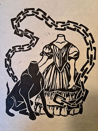
A boggart is a supernatural being from English folklore. The dialectologist Elizabeth Wright described the boggart as 'a generic name for an apparition'; folklorist Simon Young defines it as 'any ambivalent or evil solitary supernatural spirit'. Halifax folklorist Kai Roberts states that boggart ‘might have been used to refer to anything from a hilltop hobgoblin to a household faerie, from a headless apparition to a proto-typical poltergeist’. As these wide definitions suggest boggarts are to be found both within and out of doors, as a household spirit or a malevolent genius loci inhabiting fields or other topographical features.The 1867 book Lancashire Folklore by Harland and Wilkinson, makes a distinction between "House boggarts" and other types. Typical descriptions show boggarts to be malevolent. It is said that the boggart crawls into people's beds at night and puts a clammy hand on their faces. Sometimes he strips the bedsheets off them. The household boggart may follow a family wherever they flee. One Lancashire source reports the belief that a boggart should never be named: if the boggart was given a name, it could neither be reasoned with nor persuaded, but would become uncontrollable and destructive.

<span class="mw-page-title-main">Wirksworth</span> Market town in Derbyshire, England

Wirksworth is a market, and former quarry town in the Derbyshire Dales district of Derbyshire, England. Its population of 4,904 in the 2021 census was estimated at 5,220 in 2023. Wirksworth contains the source of the River Ecclesbourne. The town was granted a market charter by Edward I in 1306 and still holds a market on Tuesdays in the Memorial Gardens. The parish church of St Mary's is thought to date from 653. The town developed as a centre for lead mining and stone quarrying. Many lead mines were owned by the Gell family of nearby Hopton Hall.

<span class="mw-page-title-main">Fingest</span> Human settlement in England

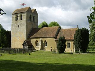
Fingest is a village in Buckinghamshire, England. It is in the Chiltern Hills near the border with Oxfordshire. It is about six miles WSW of High Wycombe. It lies in the civil parish of Hambleden.

<span class="mw-page-title-main">Taston</span> Human settlement in England

Taston is a hamlet in Spelsbury civil parish, about 1.6 miles (2.6 km) north of Charlbury and 4 miles (6.4 km) southeast of Chipping Norton, Oxfordshire.

<span class="mw-page-title-main">Stamford Bridge, East Riding of Yorkshire</span> Village and civil parish in the East Riding of Yorkshire, England

Stamford Bridge is a village and civil parish on the River Derwent in the East Riding of Yorkshire, England, approximately 5 miles (8 km) east of York and 22 miles (35 km) west of Driffield. The village sits astride an ancient ford on the River Derwent.

<span class="mw-page-title-main">North Pennines</span> Range of hills in northern England

The North Pennines is the northernmost section of the Pennine range of hills which runs north–south through northern England. It lies between Carlisle to the west and Darlington to the east. It is bounded to the north by the Tyne Valley and to the south by the Stainmore Gap.

<span class="mw-page-title-main">Brignall</span> Human settlement in England

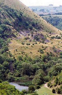
Brignall village is located in an elevated position adjacent to the River Greta, about 2 km upstream from Greta Bridge. The village is within the Teesdale district of south-west County Durham, England, the nearest town is the market town of Barnard Castle. The village is best known for the scenic valley section of the River Greta known as Brignall Banks, which is a Site of Special Scientific Interest.

<span class="mw-page-title-main">Sockburn</span> Village in County Durham, England

Sockburn is a village and former civil parish, now in the parish of Neasham, in the Darlington district, in the ceremonial county of Durham, England. It is situated at the apex of a meander of the River Tees, to the south of Darlington, known locally as the Sockburn Peninsula. Today, all that remains of the village is an early nineteenth-century mansion, a ruined church and a farmhouse built in the late eighteenth century.

<span class="mw-page-title-main">Hob Hurst's House</span> Bronze Age barrow in Derbyshire, England

Hob Hurst's House is a Bronze Age barrow on Beeley Moor near Bakewell in Derbyshire. It is unique in that instead of the normal round shape, Hob Hurst's barrow is rectangular. Originally made with 13 stones, only five remain today.

<span class="mw-page-title-main">Kershope Burn</span> River in Scotland

Kershope Burn is a small river; a tributary of both the Liddel Water and the River Esk; its final destination is the Solway Firth. The early stages begin in the Border Forest, from where it flows in a south westerly direction, followed in its entirety by the border between England and Scotland.

<span class="mw-page-title-main">River Caldew</span> River in Cumbria, England

The River Caldew is a river running through Cumbria in England. The river rises high up on the northern flanks of Skiddaw, in the Northern Fells area of the English Lake District, and flows in a northerly direction until it joins the River Eden on the north side of the city of Carlisle.

<span class="mw-page-title-main">Cade's Road</span> Roman road that ran from the Humber to Newcastle, England

Cade's Road is a Roman Road in north-east England. It is named after John Cade of Durham, an 18th-century antiquarian who in 1785 proposed its existence and possible course from the Humber Estuary northwards to the River Tyne, a distance of about 100 miles (160 km). The road's Roman name is unknown. Although evidence exists for such a road on some parts of the proposed route, there is still some doubt regarding its exact course.

<span class="mw-page-title-main">Rosedale, North Yorkshire</span> Valley in North Yorkshire, England

Rosedale is a valley located almost in the centre of the North York Moors national park in North Yorkshire, England. The nearest town is Kirkbymoorside, some 7 miles (11 km) to the south. Rosedale is surrounded by moorland. To the north-west sits Blakey Ridge at over 1,300 feet (400 m) above sea level. At Dale Head is the source of the River Seven,which flows down the valley to join the River Rye at Little Habton near Malton. At its southern end Rosedale is squeezed between Spaunton Moor and Hartoft Rigg, where the river flows out through Forestry Commission woodland before passing the village of Cropton to reach the plains of the Vale of Pickering.

<span class="mw-page-title-main">Wootton, West Oxfordshire</span> Human settlement in England

Wootton is a village and civil parish on the River Glyme about 2 miles (3 km) north of Woodstock, Oxfordshire. In recent years the village is sometimes referred to as Wootton-by-Woodstock to distinguish it from Wootton, Vale of White Horse. The 2011 census recorded the parish's population as 569.

<span class="mw-page-title-main">Farndale</span> Valley in North Yorkshire, England

Farndale is a valley and community in North Yorkshire, England, which is known for the daffodils which flower each spring along a 7-mile (11 km) stretch of the River Dove. The valley is in the North York Moors National Park, some 11 miles (18 km) north of Kirkbymoorside, the nearest town. Pickering is some 17 miles (27 km) to the south-east and Helmsley 17 miles (27 km) to the south-west.

<span class="mw-page-title-main">Runswick Bay</span> Village in North Yorkshire, England

Runswick Bay is a bay in North Yorkshire, England. It is also the name of a village located on the western edge of the bay. It is 5 miles (8 km) north of Whitby, and close to the villages of Ellerby and Hinderwell. It is a popular tourist attraction due to its picturesque cliffside village, stunning coastal walks, fossil hunting and Runswick Sands, a white sand beach. It is on the Cleveland Way national trail. Runswick Bay was chosen as Beach of the Year 2020 by The Sunday Times.

<span class="mw-page-title-main">Sevenhampton, Gloucestershire</span> Human settlement in England

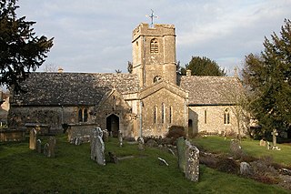
Sevenhampton is a village and civil parish in Cotswold District, Gloucestershire. The parish is located in the Cotswolds in an area designated as an Area of Outstanding Natural Beauty. Most of the parish population reside in the two main settlements of Sevenhampton village and Brockhampton village, both are located in the valley of the River Coln.

<span class="mw-page-title-main">Whitfield, Derbyshire</span> Human settlement in England

Whitfield is a hamlet and former parish in Derbyshire, England. It is half a mile (1km) south of Glossop Town Hall, south of Glossop Brook between Bray Clough and Hurst Brook. Whitfield was one of the original townships in the ancient Parish of Glossop. Up to the latter part of the 18th century the hamlet was devoted mostly to agriculture with an area of 2,608 statute acres. The area rises from about 169m to about 266m above mean sea level.

<span class="mw-page-title-main">Hannah's Meadows</span>

Hannah's Meadows is a Site of Special Scientific Interest in the Teesdale district of south-west County Durham, England. It consists of three fields, located at Low Birk Hatt Farm, on the north side of Blackton Reservoir, in Baldersdale, some 7 km west of the village of Cotherstone. The site is named after Hannah Hauxwell, whose farm it was for over 50 years.

Hobb may refer to:

References

Citations

  1. Atkinson 1868, pp. 262–263.
  2. 1 2 3 4 5 6 Scott 1965, pp. 108–109.
  3. Atkinson, Philip. Folk Tales of North East England.
  4. A Dictionary of English Folklore. 2000, 2003, Oxford University Press.
  5. 1 2 See WiKtionary: English < hob > Etymology 2: "From Middle English Hob (a diminutive of Robin, an Old French diminutive of Robert)."
  6. Scott, Charles C. P. (1895). "Hob". Transactions and Proceedings of the American Philological Association. Vol. 26. American Philological Association.
  7. "Cove-Gods". An Other Dictionary.
  8. "Whitby Myth and Folklore: Hob", Whitby Online
  9. 1 2 John Christopher Atkinson (1868). A Glossary of the Cleveland Dialect (1st ed.).
  10. Roberts, Kai (2013). Folklore of Yorkshire. The History Press. ISBN   9780752489544
  11. Bane, Theresa (2013). "Hob". Encyclopedia of Fairies in World Folklore and Mythology. McFarland. ISBN   9781476612423
  12. Wright, Elizabeth Mary (1913). Rustic Speech and Folk-Lore (2nd ed.)
  13. Terence W. Whitaker (1983). Yorkshire's Ghosts and Legends. Granada Publishing.
  14. Henderson, William (1879). Notes on the Folk-Lore of the Northern Counties of England and the Borders (2nd ed.).
  15. Atkinson 1868, p. 190.
  16. 1 2 Atkinson 1868, p. 263.
  17. 1 2 3 4 Atkinson 1868, pp. 262.
  18. Scott 1895, pp. 103.
  19. 1 2 Crofton 2014, p. 88.
  20. See Robin Hood § Mythology.

Web

Historic England

Maps

  1. "MAGiC MaP: NZ 654 202 – Hob Hill – Saltburn-by-the-Sea". Natural England, Magic in the Cloud.
  2. "MAGiC MaP: NZ 813 155 – Hob Hole – Calais Beck – Runswick Bay". Natural England, Magic in the Cloud.
  3. "MAGiC MaP: NZ 646 124 – Hob on the Hill – Commondale Moor". Natural England, Magic in the Cloud.
  4. "MAGiC MaP: NZ 838 117 – Mulgrave Castle (Norman), Mulgrave woods". Natural England, Magic in the Cloud.
  5. "MAGiC MaP: NZ 487 083 – Hobshaddow Wood – Hutton Rudby". Natural England, Magic in the Cloud.
  6. "MAGiC MaP: NZ 666 078 – Hob Hole Beck – Eskdale". Natural England, Magic in the Cloud.
  7. "MAGiC MaP: SE 716 954 – Hobb Crag – Rosedale Abbey". Natural England, Magic in the Cloud.
  8. "MAGiC MaP: SE 661 944 – Hobthrush Rook – Kneysbeck – Farndale West". Natural England, Magic in the Cloud.
  9. "MAGiC MaP: NU 123 416 – St Cuthbert's Isle (Hobthrush)". Natural England – Magic in the Cloud.
  10. "MAGiC MaP: NT 586 109 – Hobkirk near Hawick, Scottish Borders". Natural England – Magic in the Cloud.
  11. "MAGiC MaP: NY 567 901 – Hobb's Flow – Kielder Mires SSSI". Natural England – Magic in the Cloud.
  12. "MAGiC MaP: SK 027 932 – Hobroyd – Whitfield". Natural England – Magic in the Cloud.
  13. "MAGiC MaP: SK 043 928 – Hob Hill – Whitfield". Natural England – Magic in the Cloud.
  14. "MAGiC MaP: SK 176 713 – Hob's House Cave – Monsal Dale". Natural England, Magic in the Cloud.
  15. "MAGiC MaP: SK 287 692 – Hob Hurst's House – Beeley Moor". Natural England, Magic in the Cloud.
  16. "MAGiC MaP: SK 288 527 – Hob Hall and Hob Wood – Wirksworth". Natural England – Magic in the Cloud.
  17. "MAGiC MaP: SP 390 395 – Jester's Hill, Shutford near Banbury". Natural England, Magic in the Cloud.
  18. "MAGiC MaP: SP 423 366 – Hobb Hill, Bloxham near Banbury". Natural England, Magic in the Cloud.
  19. "MAGiC MaP: SP 411 291 – Hobbs Hole Farm – Great Tew". Natural England, Magic in the Cloud.
  20. "MAGiC MaP: SP 422 204 – Hobbard's Hill – Wootton-by-Woodstock". Natural England, Magic in the Cloud.
  21. "MAGiC MaP: SX 185 694 – Hobb's Hill near Hobb's Hill tin mine, Cornwall". Natural England, Magic in the Cloud.

Explanatory notes

  1. J. C. Atkinson. "Hob". Cleveland Dialect. "The appellation of a spirit, or being of elf-nature, who must once have occupied a prominent place in the belief or popular faith of the people of the district." p. 262. [1]
  2. Harry J. Scott. Yorkshire. [2] "In the moorland areas the farming community preserved their old customs ... Cut off from the outside world except for rare occasions, a supernatural world provided explanations ... There were many Hobs – which might be good or evil spirit ... A good Hob would help his master bring in the hay or cure an ailing pig ... A bad Hob would pester a man so that all went ill ... Good or bad, a self-respecting Hob would attach himself to a family and stay with them ... [2]
  3. J. C. Atkinson. "Flit". Cleveland Dialect . "1. To remove one's goods, household furniture, and gear generally, in the process of removing from one tenement or residence to another." p. 190. [15]
  4. 1 2 3 J.C.Atkinson – Cleveland Dialect < Hobtrush >
    ..."Hobtrush Hob, a being once held to frequent a certain cave in the Mulgrave Woods...
    ..."he is supposed to haunt woods only : Hob o' t' hyrst... [16]
  5. J.C.Atkinson – Cleveland Dialect < Hob >
    ..."Probably, like the nisses of popular faith in Denmark, there were many Hobs, each with a local habitation and a local name... [17]
  6. Harry J. ScottPortrait of Yorkshire
    ..."Good or bad, a self-respecting Hob would attach himself to a family and stay with them... [2]
  7. Charles Scott – The Devil and his Imps
    ..."I suppose it to have been existent as early as 1489, at which date...Hobbe Hyrste... [18]
  8. J.C.Atkinson – Cleveland Dialect < Hob >
    ..."Certainly, it is not impossible that Hob-thrush, as well as Hob-thrust, may be a corruption of this assumed Hob o' t' hurst... [17]
  9. J.C.Atkinson – Cleveland Dialect < Hob >
    ..."Hobt'rush Rook on the Farndale Moors...Obtrush Rook... [17]
  10. 1 2 3 J.C.Atkinson – Cleveland Dialect < Hob >
    ..."Thus there is a Hob Hole at Runswick, a Hob Hole near Kempswithen... [17]
  11. 1 2 Historic England..."Obtrusch round cairn was originally known as Hobthrush Rook... [HE 1]
  12. Harry J. ScottPortrait of Yorkshire
    ..."This may explain why you will so frequently find "Hob" place names in Cleveland... [2]
  13. 1 2 MAGiC MaP – Help
    1. Use Table of Contents for Colour mapping.
    2. There may be intermittent problems with the magic.defra.gov.uk website, if so then try again another time.
  14. Hob Hill is above a deep river gorge known locally as The Fairy Glen.
  15. Hob on the Hill is the meeting point for three parish boundaries:
    • East – LOCKWOOD CP
    • West – GUISBOROUGH CP
    • South – COMMONDALE CP
  16. The exact location of the cave, if one exists, is not known. The grid reference is for the Norman Castle in Mulgrave woods.
  17. Hob Hole Beck is upstream from Dibble Bridge [HE 6]
  18. Jester's Hill is 2.5 miles (4.0 km) north-west of Hobb Hill, Bloxham.
  19. Ian Crofton. Walking the Border. [19] "Hobb was formerly a familiar name for anyone called Robert or Robin. [5] The English soldiery gave the nickname 'King Hobbe' to Robert the Bruce and sang rather a rude song about him in Middle English. ... Hob was also the name of Robin Goodfellow, the mischievous sprite also known as Puck . [20] Robin Goodfellow was associated with Will-o'-the-wisp, the pale flares of marsh gas sometime seen in boggy areas at night." [19]

General and cited sources