List of islands of Taiwan

Last updated

The islands comprising the Taiwan Area under the jurisdiction of the Republic of China (ROC) are classified into various island groups. The island of Taiwan, also known as Formosa, is the largest island and the main component of the ROC-controlled territories. Islands that are claimed by the ROC but not administered, including those under the control of the People's Republic of China, and those disputed with other countries such as Senkaku Islands and most of South China Sea Islands, are excluded from this list.

Contents

At the adoption of Additional Articles of the Constitution of the Republic of China in the 1990s, these islands collectively form the "Free area of the Republic of China" or known alternatively as "Taiwan Area", which legally defines the territorial extent under the actual control of the ROC government.

Some Taiwanese islands have various translations in English due to different systems of romanization in Chinese language in use, or derivation of differing linguistic origins from Mandarin, Hokkien, indigenous languages or other foreign languages. Some islands also have different names derived from particular historical periods which remain in use to this day. [1]

Archipelagos of Taiwan

There are in total of 168 islands, these islands can be classified into the following geographical units:

Name Chinese Mandarin
(Pinyin)
Taiwanese
(Pe̍h-ōe-jī)
Hakka
(Pha̍k-fa-sṳ)
Other nameNo. islandsMajor islands Division
Taiwan 臺灣TáiwānTâi-oânThòi-vànFormosa22Taiwan, Orchid, Green, Lamay, Guishan Multiple
Penghu 澎湖PénghúPhêⁿ-ôPhàng-fùPescadores90Penghu, Xiyu, Baisha, Cimei, Wang'an Penghu County
Kinmen 金門JīnménKim-mn̂gKîm-mùnQuemoynumerousKinmen, Lieyu, Dadan, Erdan Kinmen County
Matsu 馬祖MǎzǔMá-chó͘Mâ-chú36 Nangan, Beigan, Dongyin, Xiyin, Dongju, Xiju Lienchiang County
Wuqiu 烏坵WūqiūO͘-khiuVû-hiuOckseu2Daqiu, XiaoqiuKinmen County
Tungsha/Dongsha東沙DōngshāTang-soaTûng-sâ Pratas 1 Pratas Island Kaohsiung Municipality
Nansha南沙NánshāLâm-soaNàm-sâ Spratly 2 Taiping Island, Zhongzhou Reef Kaohsiung Municipality
There are four contemporary geopolitical definitions of the extent of "Taiwan":
  1. The state, a.k.a. the "Republic of China" (ROC), including all 168 islands administered by the ROC;
  2. The traditional Taiwan region (本島地區), excluding Kinmen, Matsu, and Wuqiu, which are traditionally parts of Fujian Province, and also excluding the ROC-controlled South China Sea Islands;
  3. The traditional region without Penghu, which is sometimes regarded as a separate region;
  4. The main island of Taiwan alone, excluding all of the nearby small islands.

Note: The Senkaku Islands, which are controlled by Japan, are disputed by the PRC (People's Republic of China) and the ROC as being a part of Taiwan (they are known as "Diaoyu" or "Diaoyutai" in Mandarin Chinese). Japan administers the Senkaku Islands as a part of the Ryukyu Islands.

List of major islands by area

List of Taiwanese islands with over 5 km2 of area. [2]

OrderName Chinese Taiwanese Hakka Geographical unitAdministrative DivisionArea (km²)
1Taiwan Main Island/ Formosa臺灣本島Tâi-oân pún-tóThòi-vàn pún-tóTaiwanmultiple35,807.82
2Kinmen Main Island金門本島Kim-mn̂g pún-tóKîm-mùn pún-tó Kinmen 4 townships Kinmen 134.25
3Penghu Main Island澎湖本島Phêⁿ-ô pún-tóPhàng-fù pún-tó Penghu Magong, Huxi Penghu 65.41
4 Orchid Island 蘭嶼Lân-sūLàn-yíTaiwan Lanyu Taitung 46.82
5Xiyu Island西嶼Sai-sūSî-yí Penghu Xiyu Penghu 17.84
Waisanding Shoal外傘頂洲Gōa-sòaⁿ-téng-chiuNgoi-san táng-chûTaiwan Kouhu Yunlin 17.22
6 Green Island 綠島Le̍k-tóLiu̍k-tóTaiwan Lüdao Taitung 15.09
7 Lesser Kinmen Island (Lieyu)小金門島Sió-kim-mn̂g-tóSéu-kîm-mùn-tó Kinmen Lieyu Kinmen 14.85
8Baisha Island白沙島Pe̍h-soa-tóPha̍k-sâ-tó Penghu Baisha Penghu 13.88
9 Nangan Island (Matsu)南竿島Lâm-kan-tóNàm-kôn-tó Matsu Nangan Lienchiang 10.43
10Cimei/Qimei Island七美嶼Chhit-bí-tóChhit-mî-yí Penghu Cimei Penghu 7.59
11 Lamay Island 琉球嶼Liû-khiû-sūLiù-khiù-yíTaiwan Liuqiu Pingtung 6.80
12Wang'an Island望安島Bāng-oaⁿ-tóMong-ôn-tó Penghu Wang'an Penghu 6.74
13Beigan Island北竿島Pak-kan-tóPet-kôn-tó Matsu Beigan Lienchiang 6.44

List of islands by geographical unit

Taiwan proper

Location map of outlying islands governed by Taiwan Kinmen,Matsu,Wuciou.png
Location map of outlying islands governed by Taiwan
Penghu Islands Penghu administration.svg
Penghu Islands

Penghu/Pescadores

Kinmen/Quemoy

Kinmen County Kinmen.PNG
Kinmen County

[6] [7] [8] [9] [10]

Matsu Islands

[28] [29] [30]

Lienchiang County (Matsu Islands) Lienchiang County Map (English).svg
Lienchiang County (Matsu Islands)

Wuqiu/Ockseu

[34]

South China Sea Islands

Map of various countries occupying the Spratly Islands Spratly with flags.jpg
Map of various countries occupying the Spratly Islands

Disputed islands

The highly controversial sovereignty disputes over both the Japan-controlled Senkaku Islands and the South China Sea Islands (which are disputed and controlled by several countries) are complex with the disputed status of both Taiwan (the territories outlined in the 1951 Treaty of San Francisco) and the Republic of China (ROC) which controls Taiwan. As the ROC and the People's Republic of China (PRC) still compete their de jure claim as the sole legitimate government of the entire China, they effectively lay claim to the same extent of islands, including the South China Sea Islands and the Senkaku Islands, among others. [35] This makes these disputes multi-layered and therefore virtually impossible to solve by following the guidelines of international law.

The ROC maintains its historical claims to all of the South China Sea Islands. [36] [37] They are also claimed by five other claimants, namely the PRC, Vietnam, the Philippines, Malaysia, and Brunei. The islands within the Pratas and Spratly Islands which remain under the control of the ROC are assigned to Cijin District, Kaohsiung City, thus technically defining these islands to be part of the "Taiwan Area". The United Nations considers the South China Sea to be "international waters" and does not acknowledge any of the South China Sea Islands as "true islands". The acknowledgement of these islands as "true islands" is crucial because the definition of "islands" would justify the creation of an exclusive economic zone around them, which can be used to cut off international shipping lanes and to acquire natural resources such as oil which lie beneath the ocean.

Meanwhile, the Japanese-controlled Senkaku Islands [38] are claimed by the ROC as "Diaoyutai Islands" within Toucheng Township, Yilan County [39] and are considered to be part of geographic and provincial Taiwan by the ROC. The Senkaku Islands lie about 186 kilometres from the northeast of Taiwan Island, and situated roughly 330 kilometres from the east of mainland China. They form the westernmost extremity of the "Ryukyu Islands", which Japan administers as Okinawa Prefecture. The PRC also claims the Senkaku Islands as "Diaoyu Islands" as part of its claimed "Taiwan Province".

The PRC claims the islands of Taiwan and Penghu as part of its 23rd Taiwan Province, together with the Japanese-controlled Senkaku Islands (claimed as "Diaoyudao Islands"), which are also claimed by the ROC as part of its own Taiwan Province. The PRC claims Kinmen (Quemoy) as a county of the prefecture-level city Quanzhou, in Fujian Province. Matsu is claimed as part of Lianjiang County, part of Fuzhou, in Fujian Province. The Wuqiu islands are claimed as part of Xiuyu District, a district of the prefecture-level city Putian, in Fujian Province. Pratas Island is claimed as part of Chengqu in Shanwei (Swabue) Guangdong Province. The Nansha Islands controlled by the ROC, i.e. Taiping Island and Zhongzhou Reef, are claimed as part of Sansha, in Hainan Province. The PRC thus claims the ROC-controlled islands as part of its own Taiwan Province (Taiwan and Penghu), Fujian Province (Kinmen, Matsu and Wuqiu), Guangdong Province (Dongsha) and Hainan Province (Nansha).

See also

Related Research Articles

<span class="mw-page-title-main">Kinmen</span> County of the Republic of China (Taiwan)

Kinmen, alternatively known as Quemoy, is a group of islands governed as a county by the Republic of China (Taiwan), only 10 km (6.2 mi) east from the city of Xiamen in Fujian, located at the southeastern coast of the People's Republic of China, from which they are separated by Xiamen Bay. Kinmen is also located 187 km (116 mi) west from the closest shoreline of the island of Taiwan across the Taiwan Strait.

<span class="mw-page-title-main">Juguang, Lienchiang</span> Rural township

Juguang Township / Jyuguang Township, also spelled Chukuang, is a rural township of Lienchiang County, Republic of China (Taiwan). Juguang Township includes two major islands, Dongju Island and Xiju Island, as well as some islets.

<span class="mw-page-title-main">Xiang'an, Xiamen</span> District in Fujian, Peoples Republic of China

is one of the districts of Xiamen, People's Republic of China. It is located on the mainland, and is Xiamen's easternmost district.

<span class="mw-page-title-main">Lieyu</span> Rural township in Taiwan

Lieyu Township (Liehyu) is a rural township in Kinmen County (Quemoy), Fujian Province, Republic of China (Taiwan). It consists mainly of three islands located to the west of Greater Kinmen and immediately to the east of Xiamen (Amoy) of the People's Republic of China: Lesser Kinmen, Dadan, and Erdan.

<span class="mw-page-title-main">Fuchien Province, Republic of China</span> Nominal province of the Republic of China (Taiwan)

Fuchien Province, also romanized as Fujian and rendered as Fukien, is a nominal province of the Republic of China without formal administrative function. It includes three small archipelagos off the coast of the Fujian Province of the People's Republic of China, namely the Matsu Islands, which make up Lienchiang County, and the Wuqiu Islands and Kinmen Islands, which make up Kinmen County. The seat of the administrative centre is Jincheng Township of Kinmen County which serves as its de facto capital. The province is also known as the Golden Horse, after the literal reading of the Chinese character abbreviation for "Kinmen-Matsu".

<span class="mw-page-title-main">Xiuyu, Putian</span> District in Fujian, Peoples Republic of China

Xiuyu District is a district of the city of Putian, Fujian, People's Republic of China. The district executive, legislature and judiciary are in Hushi Town (笏石镇), together with the CPC and PSB branches.

<span class="mw-page-title-main">Wangan, Penghu</span> Rural township in Republic of China

Wangan Township / Wang-an Township is a rural township in Penghu County, Taiwan. It is the second smallest township in Penghu County after Cimei Township. The township is made up of nineteen islands, six of which are inhabited.

<span class="mw-page-title-main">Dadan Island</span> Island in Fujian, Republic of China

Dadan Island is an island in Lieyu Township, Kinmen County, Fujian Province, Republic of China (Taiwan). The island is in the Taiwan Strait, along the coast of Mainland China. It is located approximately 12,000 m (7.5 mi) to the southwest of Lesser Kinmen (Lieyu) and approximately 4,400 m (14,400 ft) from Xiamen (Amoy).

<span class="mw-page-title-main">Wuqiu, Kinmen</span> Rural township in Fukien, Republic of China

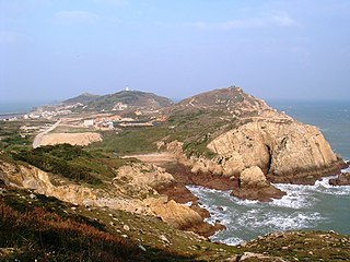
Wuqiu is a rural township of Kinmen County (Quemoy), Taiwan (ROC) made up of a group of islands in the Taiwan Strait comprising two major islands, Daqiu and Xiaoqiu. Wuqiu Township is nominally de jure part of Futian County, Fukien of the Republic of China. It is the smallest township in Kinmen County and is located 72 nmi (133 km) northeast of the rest of the county. The township is 73 nmi (135 km) from the Port of Taichung on Taiwan. The closest territory under China (PRC) control is the neighboring Luci Island, Xiuyu District, Putian, Fujian, which is 9 nmi (17 km) to the north-northwest. Greater Qiu Island is the site of the Wuqiu Lighthouse.

<span class="mw-page-title-main">Erdan Island</span> Island in Lieyu, Kinmen, Republic of China

Erdan Island is an island in Lieyu Township, Kinmen County (Quemoy), Taiwan. The island has been called Seao-tan. Erdan Island is 12 km (7.5 mi) from Greater Kinmen Island and 4 km (2.5 mi) from Xiamen (Amoy) Island.

Dongding Island is an 0.0160 square kilometer island in the Taiwan Strait in Jinhu Township, Kinmen County (Quemoy), Fujian Province, Republic of China (Taiwan). The island is the southernmost point of Kinmen County. The island is near Longhai City, Zhangzhou, Fujian, China.

<span class="mw-page-title-main">Fuxing Islet</span> Islet west of Taiwan

Fuxing Islet (Chinese: 復興; pinyin: Fùxīng Yǔ; Wade–Giles: Fu4-hsing13; Pe̍h-ōe-jī: Ho̍k-heng-sū; lit. 'rejuvenation islet') (Fuhsing Islet, 后宅嶼 Hou-chai Hsü) is an islet located south of Lesser Kinmen (Lieyu) in Lieyu Township, Kinmen County (Quemoy), Fujian Province, Republic of China (Taiwan). The name of the islet was originally Phaktia (Chinese: 覆鼎嶼; pinyin: Fùdǐng Yǔ; Pe̍h-ōe-jī: Phak-tiáⁿ-sū; lit. 'inverted rice-boiler islet').

<span class="mw-page-title-main">Shi Islet</span> Islet west of Taiwan.

Shi Islet is an islet located northwest of Lesser Kinmen (Lieyu) in Lieyu Township, Kinmen County (Quemoy), Fujian Province, Republic of China (Taiwan). Military personnel are stationed on Shi Islet.

<span class="mw-page-title-main">Menghu Islet</span> Islet west of Taiwan.

Menghu Islet is an islet located southwest of Lesser Kinmen (Lieyu) in Lieyu Township, Kinmen County (Quemoy), Fujian Province, Republic of China (Taiwan). The islet was originally named Hu-tzu Hsü (虎仔嶼).

<span class="mw-page-title-main">Beiding Island</span> Island west of Taiwan.

Beiding Island is an island located east of Greater Kinmen in Jinhu Township, Kinmen County, Fujian Province, Republic of China (Taiwan).

<span class="mw-page-title-main">Dadeng Subdistrict</span> Subdistrict in Republic of China, Peoples Republic of China

Dadeng Subdistrict is a group of three islands under the de facto administration of the People's Republic of China as part of Xiang'an District of Xiamen in southern Fujian, but is also claimed by the Republic of China and historically constituted as an insular subdistrict in Kinmen County (Quemoy).

<span class="mw-page-title-main">Binlang Islet</span> Islet west of Lesser Kinmen, Taiwan (ROC).

Binlang Islet is an islet located in Lieyu Township, Kinmen County (Quemoy), Taiwan (ROC). The islet can be seen from the shore near Lingshui Lake and from the shore near Shaxi Fort (沙溪堡) in the southwestern part of Lesser Kinmen (Lieyu) as well as from Siming District, Xiamen (Amoy), Fujian, China (PRC). The highest point on the islet is 47 m (154 ft) above sea level.
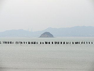
Luci Island (Chinese: 鸬鹚 / 鸬鹚屿; pinyin: Lúcí Dǎo/Yǔ/Xù; Wade–Giles: Lu2-tzʻŭ2 Tao3/Yü3/Hsü4; lit. 'cormorant island') (also Loutz Island (Lu-tzʻu, Lucih) and Lusi Island (Lusih, Lu-ssu) (Chinese: 鷺鷥; pinyin: Lùsī Dǎo; Wade–Giles: Lu4-ssŭ1 Tao3; lit. 'little egret island') is an uninhabited island southeast of the Asian mainland in Pinghai Town (平海镇), Xiuyu District, Putian, Fujian, People's Republic of China (PRC) and 9 nautical miles (17 km) north-northwest of Wuciou Township (Ockseu), Kinmen County (Quemoy), Republic of China (Taiwan) which can be seen from the island.

References

  1. 1 2 臺灣歷史地圖 增訂版[Taiwan Historical Maps, Expanded and Revised Edition] (in Chinese (Taiwan)). Taipei: National Museum of Taiwan History. February 2018. pp. 14, 154, 158. ISBN   978-986-05-5274-4. 一地數名,反映了16-17世紀外界對臺灣的認知。 (Note: On pages 154 and 158, Baiyan is colored light green as is the rest of Kinmen County, excluding the Dadeng (Tateng) Islands. The islet is found in several other maps of Kinmen County (excluding the Dadeng Islands) included in the book.)
  2. 05-19 臺灣島嶼面積 [Location and Area of Islands in Taiwan]. Ministry of the Interior (in Chinese (Taiwan) and English). Retrieved 20 October 2019.
  3. 記者盧賢秀,"北方三島小檔案" "存档副本". Archived from the original on 2010-09-01. Retrieved 2010-08-30. 島嶼的最東端是台灣極東點,, Liberty Times,2010-8-30.
  4. "PENGHU From island to island" (PDF). Penghu County Government. 2010s. Retrieved 31 October 2019.
  5. 澎湖的島嶼. 澎湖國家風景區管理處 (in Chinese (Taiwan)). Retrieved 2 November 2019.
  6. "金門地區離島通航航道公告圖" (PDF) (Map). Coast Guard Administration (Taiwan) (in Chinese (Taiwan)). n.d. Retrieved 25 August 2019. 目嶼 三擔島 二擔島 Erhtan Island 大膽島 Tatan Island 大南礁 兔嶼 猛虎嶼 Menghu Islet 復興嶼 Fuhsing Islet 煙嶼(三角礁) 檳榔嶼 三嶼(三擔) 牛心 黃嶼 門口礁 獅嶼 桂子礁 烏礁 後頭嶼 小金門島 HSIAOKINMEN ISLAND (烈嶼)(Lienyü) 金門嶼 Kinmen Islet 大墘 建功嶼 大岩嶼 Dayan Islet 黑岩 洋山嶼 西園嶼 西山嶼(後嶼)東割 草嶼 北碇頭 母嶼 Muyü 北碇島 Peiting Island
  7. 1 2 金門縣行政區域圖 (Map) (in Chinese (Taiwan)). Ministry of the Interior. November 2017. Retrieved 9 August 2019. 北碇島 母嶼 白巖 草嶼 東割 烽遂角 后嶼 官澳礁 西園嶼 建功嶼 黑巖 大岩嶼 烏礁 桂子礁 獅嶼 牛心礁 小擔 檳榔嶼 烈嶼 復興嶼 猛虎嶼 兔嶼 石山 大膽島 二擔島 三擔島 四擔島 五擔 大坵島 小坵島
  8. 金門地區限制(禁止)水域圖 (PDF) (Map) (in Chinese (Taiwan)). Mainland Affairs Council. n.d. Retrieved 9 August 2019. 二.限制水域範圍:大金門地區低潮線向外延伸東方海面四千至六千公尺,南方海面八千至一萬公尺,北碇以東海面四千公 尺,大、二膽南海面二千公尺一線以內海域 三、禁止水域範圍:大金門地區低潮線向外延伸東方海面四千公尺,南方海面八千公尺,馬山北方一千五百公尺,北碇以東 海面四千公尺,大、二膽北、西、南海面二千公尺,小金門西海面、檳榔嶼、三腳礁、牛心礁、赤角礁一線以內海域
  9. 辞海第六版. Cihai (Sixth Edition) (in Chinese). 上海. Shanghai: 上海辞书出版社. Shanghai Lexicographical Publishing House. September 2009. p. 1124. ISBN   9787532628599. 金门 县名。在福建省东南海上、泉州市西南部。现由台湾省管辖。由以金门岛为主的大、小59个岛屿组成。面积149平方千米,人口约6.45万(2004年)。明置金门千户所,清设金门县丞,属同安县。1913年改隶思明县,1914年析置金门县。1928年直属福建省。农产有甘薯、花生等。矿产有玻璃砂、高岭土、铝土、煤。工业有机械、食品等。特产贡糖、高粱酒、金门马等。通公路。名胜古迹有成功洞、鲁王墓、水尾塔等。{...}金门岛 亦称"大金门岛"、"吾洲屿"。在福建省东南部、厦门港口外台湾海峡中。属金门县,现由台湾省管辖。岛形如哑铃,东西宽,南北狭,中多丘陵,沿海多港湾、口岸。东西长约20千米,面积131.7平方千米。其西有小金门岛。名胜古迹有牧马侯(陈渊)祠、鲁王墓、海印寺、古岗湖、中山纪念林等。
  10. "Geographic environment". Kinmen National Park . Archived from the original on 28 October 2018. Retrieved 27 July 2019. The 12 islands and islets comprising Kinmen mainland, Lieyu (small Kinmen), Da Dan, Er Dan, Dong Ding, Beiding, Cao islet, Hou islet, Jiangong islet, Fuxing islet, Menghu islet, Shi islet occupy an area of 150 square meters in total.
  11. Mu Yu (Approved - N) at GEOnet Names Server, United States National Geospatial-Intelligence Agency
  12. 1 2 3 金門縣行政區域圖[Kinmen County] (Map) (in Chinese (Taiwan) and English). Ministry of the Interior and Kinmen County Government. September 2007. ISBN   978-986010742-5. [map]
    Dabo Reef 大撥{...}Siaobo Reef 小撥{...}Baiyan Island 白巖
    {...}
    [reverse, column 2]
    名稱(Name) 英文(English) 索引(Index)
    {...}
    白巖 Baiyan Island O1

    (Note: The County/City Boundary (縣(市)界) as shown in this map includes Dabo Reef, Siaobo Reef and Baiyan Island within Kinmen County.)
  13. Dongge (Approved - N) at GEOnet Names Server, United States National Geospatial-Intelligence Agency
  14. Guan’ao Jiao (Approved - N) at GEOnet Names Server, United States National Geospatial-Intelligence Agency
  15. Xiyuan Yu (Approved - N) at GEOnet Names Server, United States National Geospatial-Intelligence Agency
  16. Gou Yu (Approved - N) at GEOnet Names Server, United States National Geospatial-Intelligence Agency
  17. Hei Yan (Approved - N) at GEOnet Names Server, United States National Geospatial-Intelligence Agency
  18. Dayan Yu (Approved - N) at GEOnet Names Server, United States National Geospatial-Intelligence Agency
  19. "NG 50-15 HSIA-MEN". Washington, D. C.: Army Map Service. 1954 via Perry–Castañeda Library Map Collection. Ta-yen Hsü
  20. Wu Jiao (Approved - N) at GEOnet Names Server, United States National Geospatial-Intelligence Agency
  21. Yan Yu (Approved - N) at GEOnet Names Server, United States National Geospatial-Intelligence Agency
  22. Xiaodan (Approved - N) at GEOnet Names Server, United States National Geospatial-Intelligence Agency
  23. Menkou Jiao (Approved - N) at GEOnet Names Server, United States National Geospatial-Intelligence Agency
  24. Tu Yu (Approved - N) at GEOnet Names Server, United States National Geospatial-Intelligence Agency
  25. Sandan (Approved - N) at GEOnet Names Server, United States National Geospatial-Intelligence Agency
  26. Sidan (Approved - N) at GEOnet Names Server, United States National Geospatial-Intelligence Agency
  27. Wudan (Approved - N) at GEOnet Names Server, United States National Geospatial-Intelligence Agency
  28. 擬定連江縣風景特定區計畫說明書 [Proposed Lienchiang County Designated Scenic Areas Plan Manual](PDF). June 2002. p. 16. Archived from the original (PDF) on 8 January 2020. 南竿鄉 南竿島 黃官嶼 鞋礁 北泉礁 劉泉礁 北竿鄉 鵝石 進嶼 蚌山 螺山 北竿島 浪岩 三連嶼 無名島 峭頭 小坵 大坵 龜島 中島 高登島 鐵尖島 白廟 老鼠 亮島
  29. 馬祖地區離島通航航道公告圖 (Map) (in Chinese (Taiwan)). 14 April 2017. Retrieved 9 February 2020. 東引島 Dongyin Island{...}亮島 Liangdao{...}蚌礁島{...}高登島 Gaodeng Island{...}高登石{...}鐵尖島{...}北高礁{...}西引岩{...}小坵{...}大坵{...}峭頭{...}三連嶼 Sanlian Islet{...}長岐島 Zhangqi Island{...}蚌山{...}進嶼{...}蛤蜊島{...}鵲石{...}馬祖列島 Matzu Islands{...}西石{...}黃官嶼{...}南引{...}馬祖島 Matzu Island{...}鞋礁{...}雷石{...}北泉礁島{...}高間礁{...}劉泉礁{...}細皮石{...}大嶼{...}小嶼{...}永留嶼{...}西莒島 Xiju Island{...}東莒島 Dongju Island{...}莒光列島 Juguang Islands{...}林投嶼{...}
  30. 連江縣行政區域圖[Lienchiang County] (Map) (in Chinese (Taiwan) and English). Ministry of the Interior, Lienchiang County Government. August 2007. ISBN   978-986010698-5. 亮島 Liangdao Island
  31. 連江縣土地段名代碼表 (in Chinese (Taiwan)). Department of Land Administration. 16 May 2012. Retrieved 27 August 2019. 地政事務所名稱(代碼) 連江(ZA) 鄉鎮市區名稱(代碼) 北竿鄉(02) 段 小段 代碼 備註{...}大坵 0020 無名島 0021 高登 0022 峭頭 0023 進嶼 0024 亮島 0035 調整 浪岩 0036 調整 三連嶼 0039 中島 0040 調整 白廟 0041 調整 老鼠 0042 調整
  32. 連江縣土地段名代碼表 (in Chinese (Taiwan)). Department of Land Administration. 16 May 2012. Retrieved 27 August 2019. 地政事務所名稱(代碼) 連江(ZA) 鄉鎮市區名稱(代碼) 南竿鄉(01) 段 小段 代碼 備註{...}黃官嶼 0010 劉泉礁 0011 鞋礁 0012
  33. Dongsha Dao (Approved - N) at GEOnet Names Server, United States National Geospatial-Intelligence Agency
  34. 澎湖地區離島通航航道公告圖 (Map) (in Chinese (Taiwan)). 14 April 2017. Retrieved 9 February 2020. 烏坵嶼 Wuqiu Islet{...}小坵嶼
  35. Hudson, Christopher (2014). The China Handbook. p. 59. ISBN   9781134269662.
  36. http://www.asianresearch.org/articles/3115.html Archived 2011-05-14 at the Wayback Machine Taiwan's Spratly Initiative in the South China Sea
  37. "Ministry of Foreign Affairs of the Republic of China (Taiwan) reiterates its position on the South China Sea". 2015-07-07.
  38. "Situation of the Senkaku Islands". 2014-04-04.
  39. "ROC government reaffirms sovereignty over Diaoyutai Islands". 2015-07-24.