Toonpan, Queensland

Last updated

Toonpan
Queensland
Australia Queensland location map.svg
Red pog.svg
Toonpan
Coordinates 19°30′14″S146°52′19″E / 19.5038°S 146.8719°E / -19.5038; 146.8719 (Toonpan (centre of locality))
Population62 (2021 census) [1]
 • Density4.88/km2 (12.64/sq mi)
Postcode(s) 4816
Area12.7 km2 (4.9 sq mi)
Time zone AEST (UTC+10:00)
LGA(s) City of Townsville
State electorate(s) Burdekin
Federal division(s) Kennedy
Suburbs around Toonpan:
Ross River Brookhill Mount Elliot
Ross River Toonpan Mount Elliot
Ross River Barringha Mount Elliot

Toonpan is a rural locality in the City of Townsville, Queensland, Australia. [2] In the 2021 census, Toonpan had a population of 62 people. [1]

Contents

Geography

The locality is bounded to the west by the Mount Isa railway line and the Flinders Highway. [3]

The terrain varies from 50 to 190 metres (160 to 620 ft) above sea level with the higher elevations in the east of the locality, the foothills of Mount Elliot. [3]

The land use is predominantly grazing on native vegetation with a small amount of crop growing. [3]

History

The first section of the Great Northern railway line opened on 20 December 1880 and followed a southerly path from Townsville to Reid River via Stuart, Antill Plains, Toonpan, Woodstock and Calcium. [4] [5] Toonpan railway station was at 19°30′05″S146°50′10″E / 19.50129°S 146.83617°E / -19.50129; 146.83617 (now within the present-day boundaries of the suburb of Ross River). [6]

Toonpan Provisional School opened circa 1895, [7] becoming Toonpan State School on 1 January 1909. Between 1920 and 1923, it operated as a half-time school with Manton Provisional School (meaning the two schools shared a single teacher). It resumed as a full-time state school in 1923. It closed in circa 1940. [8] It was located immediately south-west of the railway station. [9] [10]

During World War II, the 29th Brigade of the Australian Army was based in Toonpan from May to September 1942. After September it moved to the Black River area, north of Townsville, before going to Papua New Guinea in January 1943. [11] [12] [ full citation needed ]

In the 1980s, the second stage of the Ross River Dam necessitated a deviation of the Flinders Highway and Mount Isa railway line (which otherwise ran straight north–south) further east. This was completed by 1986 and resulted in the closure of Toonpan and Barringha railway stations on the removed route; they were not re-established on new route. [13] [6] [14] [3]

The locality was officially named and bounded on 27 July 1991. [2]

Demographics

In the 2016 census, Toonpan had a population of 57 people. [15]

In the 2021 census, Toonpan had a population of 62 people. [1]

Related Research Articles

<span class="mw-page-title-main">Hughenden, Queensland</span> Town in Queensland, Australia

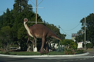
Hughenden is a rural town and locality in the Flinders Shire, Queensland, Australia. In the 2016 census, the locality of Hughenden had a population of 1,136 people.

<span class="mw-page-title-main">Flinders Highway, Queensland</span> Highway in Queensland, Australia

The Flinders Highway is a highway that crosses Queensland east to west, from Townsville on the Pacific coast to Cloncurry. The road continues as the Barkly Highway from Cloncurry to the Northern Territory border at Camooweal and beyond. The Flinders Highway passes a number of small outback towns and typical outback landscape predominates towards the inland. It was known as National Route 78 before Queensland began to convert to the alphanumeric system being adopted in Australia and is now designated as A6. The highway is also known as Overlanders Way. Its entire length is part of the National Land Transport Network.

<span class="mw-page-title-main">Richmond, Queensland</span> Town in Queensland, Australia

Richmond is a rural town and locality in the Shire of Richmond, Queensland, Australia. In the 2016 census, the locality of Richmond had a population of 648 people.

Stuart is a rural coastal suburb in the City of Townsville, Queensland, Australia. In the 2016 census, Stuart had a population of 1,386 people.

<span class="mw-page-title-main">Pentland, Queensland</span> Town in Queensland, Australia

Pentland is a rural town and locality in the Charters Towers Region, Queensland, Australia. In the 2016 census, the locality of Pentland had a population of 306 people.

<span class="mw-page-title-main">Woodstock, Queensland</span> Suburb of City of Townsville, Queensland, Australia

Woodstock is a rural town and locality in the City of Townsville, Queensland, Australia. In the 2021 census, the locality of Woodstock had a population of 270 people.

<span class="mw-page-title-main">Ross River Dam</span> Dam in southwest of Townsville, North Queensland

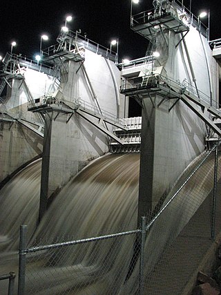
The Ross River Dam is a rock and earthfill-filled embankment dam across the Ross River, located between Kelso and Mount Stuart in the City of Townsville in northern Queensland, Australia. Built initially for flood control, Lake Ross, the impoundment created by the dam, serves as one of the major potable water supplies for the region.

<span class="mw-page-title-main">Great Northern Railway (Mt Isa line)</span>

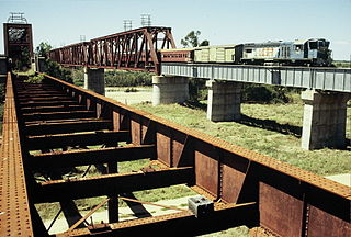
The Great Northern Railway is a 1067 mm gauge railway line in Queensland, Australia. The line stretches nearly 1,000 kilometres linking the port city of Townsville, Australia to the mining town of Mount Isa in north-west Queensland. Along with a passenger service called the Inlander, it is a major freight route connecting the Mount Isa Mines to the Port of Townsville. In 2010, the line moved 5.8 million tonnes of cargo, and this is expected to increase significantly in coming years.

<span class="mw-page-title-main">Maxwelton, Queensland</span> Town in Queensland, Australia

Maxwelton is an outback town and locality in the Shire of Richmond in central north Queensland, Australia. In the 2016 census, the locality of Maxwelton had a population of 22 people.

<span class="mw-page-title-main">Duchess, Queensland</span> Town in Queensland, Australia

Duchess is a rural town and locality in the Shire of Cloncurry, Queensland, Australia. In the 2016 census, Duchess had a population of 23 people.

Oak Valley is a rural residential locality in the City of Townsville, Queensland, Australia. In the 2021 census, Oak Valley had a population of 478 people.

<span class="mw-page-title-main">Queenton, Queensland</span> Suburb of Charters Towers, Queensland, Australia

Queenton is an eastern suburb of Charters Towers in the Charters Towers Region, Queensland, Australia. In the 2021 census, Queenton had a population of 1,236 people.

<span class="mw-page-title-main">Dotswood, Queensland</span> Suburb of Charters Towers Region, Queensland, Australia

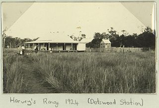
Dotswood is a rural locality in the Charters Towers Region, Queensland, Australia. In the 2021 census, Dotswood had a population of 83 people.

<span class="mw-page-title-main">Mount Elliot, Queensland</span> Suburb of City of Townsville, Queensland, Australia

Mount Elliot is a rural locality in the City of Townsville, Queensland, Australia. It contains the mountain of the same name. In the 2021 census, Mount Elliot had "no people or a very low population".

<span class="mw-page-title-main">Reid River, Queensland</span> Suburb of Charters Towers Region, Queensland, Australia

Reid River is a locality split between the Charters Towers Region and the City of Townsville in Queensland, Australia. In the 2021 census, Reid River had a population of 143 people.

Beach Holm is a coastal locality in the City of Townsville, Queensland, Australia. In the 2021 census, Beach Holm had a population of 35 people.

<span class="mw-page-title-main">Roseneath, Queensland</span> Suburb of Townsville, Queensland, Australia

Roseneath is an outer suburb of Townsville in the City of Townsville, Queensland, Australia. In the 2021 census, Roseneath had a population of 127 people.

<span class="mw-page-title-main">Barringha, Queensland</span> Suburb of City of Townsville, Queensland, Australia

Barringha is a locality in the City of Townsville, Queensland, Australia. In the 2021 census, Barringha had a population of 61 people.

Calcium is a rural locality in the City of Townsville, Queensland, Australia. In the 2021 census, Calcium had a population of 12 people.

<span class="mw-page-title-main">Silverwood, Queensland</span> Suburb of Southern Downs Region, Queensland, Australia

Silverwood is a rural locality in the Southern Downs Region, Queensland, Australia. In the 2021 census, Silverwood had a population of 58 people.

References

  1. 1 2 3 Australian Bureau of Statistics (28 June 2022). "Toonpan (SAL)". 2021 Census QuickStats. Retrieved 28 February 2023. OOjs UI icon edit-ltr-progressive.svg
  2. 1 2 "Toonpan – locality in City of Townsville (entry 44646)". Queensland Place Names. Queensland Government . Retrieved 16 November 2018.
  3. 1 2 3 4 "Queensland Globe". State of Queensland . Retrieved 8 February 2024.
  4. "Townsville". The Brisbane Courier . Vol. XXXV, no. 4, 237. Queensland, Australia. 18 December 1880. p. 7. Retrieved 5 February 2024 via National Library of Australia.
  5. "Townsville". The Darling Downs Gazette And General Advertiser . Vol. XX, no. 4089. Queensland, Australia. 21 December 1880. p. 3. Retrieved 5 February 2024 via National Library of Australia.
  6. 1 2 "Railway stations and sidings - Queensland". Queensland Open Data. Queensland Government. 2 October 2020. Archived from the original on 5 October 2020. Retrieved 5 October 2020.
  7. "The Kennedy Schools". The Evening Telegraph . Vol. 4, no. 1031. Queensland, Australia. 21 July 1904. p. 3. Retrieved 4 February 2024 via National Library of Australia.
  8. Queensland Family History Society (2010), Queensland schools past and present (Version 1.01 ed.), Queensland Family History Society, ISBN   978-1-921171-26-0
  9. "Manton" (Map). Queensland Government. 1944. Retrieved 5 February 2024.
  10. "County of Elphinstone" (Map). Queensland Government. 1922. Retrieved 5 February 2024.
  11. Personal history of William Harold Mann 1920 - 1998, member 7 Field Ambulance, 29 Brigade [ full citation needed ]
  12. The Unit Guide, Australian war Memorial, page 3,026[ full citation needed ]
  13. "Ross River Dam". Townsville City Council. Retrieved 8 February 2024.
  14. "Mount Elliott (Special)" (Map). Queensland Government. 1942. Retrieved 8 February 2024.
  15. Australian Bureau of Statistics (27 June 2017). "Toonpan (SSC)". 2016 Census QuickStats. Retrieved 20 October 2018. OOjs UI icon edit-ltr-progressive.svg