
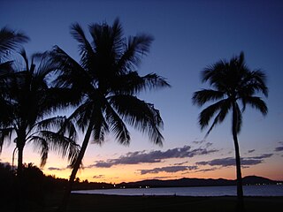
Magnetic Island is an island 8 kilometres (5 mi) offshore from the city of Townsville, Queensland, Australia. This 52 km2 (20.1 sq mi) mountainous island in Cleveland Bay has effectively become a suburb of Townsville, with 2,335 permanent residents. The island is accessible from Townsville Breakwater to Nelly Bay Harbour by ferry. There is a large 39.5 km2 (15.3 sq mi) National Park and bird sanctuary and walking tracks can be taken between the populated bays and to a number of tourist destinations such as the World War II forts.

Picnic Bay is a town and suburb of Magnetic Island in the City of Townsville, Queensland, Australia. In the 2016 census, Picnic Bay had a population of 291 people.

Nelly Bay is a town on Magnetic Island and a suburb of the City of Townsville, Queensland, Australia. In the 2016 census, Nelly Bay had a population of 1,196 people. A tourism hub on the island, it is especially significant as the site of the ferry terminal, which links it to Townsville.
Arcadia is a coastal suburb on Magnetic Island in the City of Townsville, Queensland, Australia. In the 2016 census, Arcadia had a population of 248 people.
Stuart is a rural coastal suburb in the City of Townsville, Queensland, Australia. In the 2016 census, Stuart had a population of 1,386 people.

Horseshoe Bay is a bay, town and suburb on Magnetic Island in the City of Townsville, Queensland, Australia. It is a major tourist accommodation and recreation centre on the island. In the 2016 census the suburb of Horseshoe Bay had a population of 578 people.

Oonoonba is a suburb of Townsville in the City of Townsville, Queensland, Australia. In the 2016 census, Oonoonba had a population of 1,675 people.

South Townsville is a coastal suburb of Townsville in the City of Townsville, Queensland, Australia. In the 2016 census, South Townsville had a population of 2,353 people.
Rowes Bay is a suburb of Townsville in the City of Townsville, Queensland, Australia. In the 2016 census, Rowes Bay had a population of 573 people.
Pallarenda is a northern coastal suburb of Townsville in the City of Townsville, Queensland, Australia. In the 2016 census Pallarenda had a population of 791 people.
The Cape Pallarenda Conservation Park is a protected conservation park located 10 kilometres (6.2 mi) north-east of Townsville in the Far North region of Queensland, Australia. The 44-hectare (110-acre) regional park is located within the suburb of Pallarenda.

Cluden is an outer southern suburb of Townsville in the City of Townsville, Queensland, Australia. In the 2016 census Cluden had a population of 427 people.
Saunders Beach is a coastal town and suburb of Townsville in the City of Townsville, Queensland, Australia. In the 2016 census, the suburb of Saunders Beach had a population of 409 people.
Toolakea is a coastal town and suburb in the City of Townsville, Queensland, Australia. In the 2016 census, Toolakea had a population of 205 people.

Cape Pallarenda Quarantine Station is a heritage-listed former quarantine station at 1 The Esplanade, Pallarenda, City of Townsville, Queensland, Australia. It was built from 1915 to 1916. It is also known as Northern Regional Office, Department of Environment and Resource Management, Northern Regional Office, Environmental Protection Agency, and Cape Pallarenda Coastal Battery. It was added to the Queensland Heritage Register on 23 April 1999. The building is part of Cape Pallarenda Conservation Park.

Town Common is a coastal suburb of Townsville in the City of Townsville, Queensland, Australia. In the 2016 census, Town Common had a population of 71 people.
Mount Low is a suburb of Townsville in the City of Townsville, Queensland, Australia. In the 2016 census, Mount Low had a population of 4,655 people.
Florence Bay is a suburb of Magnetic Island in the City of Townsville, Queensland, Australia. In the 2016 census Florence Bay had a population of 0 people.
Roseneath is an outer suburb of Townsville in the City of Townsville, Queensland, Australia. In the 2016 census, Roseneath had a population of 154 people.

Alma Bay is an island town within the locality of Arcadia on Magnetic Island in the City of Townsville, Queensland, Australia.
