Badger, Iowa

Last updated

Badger, Iowa
Webster County Iowa Incorporated and Unincorporated areas Badger Highlighted.svg
Location of Badger, Iowa
Coordinates: 42°36′55″N94°8′40″W / 42.61528°N 94.14444°W / 42.61528; -94.14444
Country Flag of the United States.svg  United States
State Flag of Iowa.svg  Iowa
County Webster
Area
[1]
  Total1.13 sq mi (2.91 km2)
  Land1.13 sq mi (2.91 km2)
  Water0.00 sq mi (0.00 km2)
Elevation
1,152 ft (351 m)
Population
 (2020)
  Total522
  Density464.00/sq mi (179.10/km2)
Time zone UTC-6 (Central (CST))
  Summer (DST) UTC-5 (CDT)
ZIP code
50516
Area code 515
FIPS code 19-04195
GNIS feature ID0454304

Badger is a Town in Webster County, Iowa, United States. The population was 522 at the 2020 census. [2] The town got its name from Badger Creek, which itself got its name when a group of soldiers from Fort Dodge in the early 1850s saw a badger for the first time. [3]

Contents

Geography

Badger is located at 42°36′55″N94°08′40″W / 42.615303°N 94.144454°W / 42.615303; -94.144454 (42.615303, -94.144454). [4]

According to the United States Census Bureau, the city has a total area of 1.09 square miles (2.82 km2), all land. [5]

Demographics

Historical populations
YearPop.±%
1900 240    
1910 212−11.7%
1920 244+15.1%
1930 254+4.1%
1940 251−1.2%
1950 301+19.9%
1960 340+13.0%
1970 465+36.8%
1980 653+40.4%
1990 569−12.9%
2000 610+7.2%
2010 561−8.0%
2020 522−7.0%
Source: "U.S. Census website". United States Census Bureau . Retrieved March 28, 2020. and Iowa Data Center
Source:
U.S. Decennial Census [6] [2]
The population of Badger, Iowa from US census data BadgerIowaPopPlot.png
The population of Badger, Iowa from US census data

2010 census

As of the census [7] of 2010, there were 561 people, 215 households, and 163 families living in the city. The population density was 514.7 inhabitants per square mile (198.7/km2). There were 229 housing units at an average density of 210.1 per square mile (81.1/km2). The racial makeup of the city was 97.7% White, 0.4% African American, 0.2% Native American, 0.2% Asian, and 1.6% from two or more races. Hispanic or Latino of any race were 1.2% of the population.

There were 215 households, of which 37.2% had children under the age of 18 living with them, 63.3% were married couples living together, 7.4% had a female householder with no husband present, 5.1% had a male householder with no wife present, and 24.2% were non-families. 20.9% of all households were made up of individuals, and 8.4% had someone living alone who was 65 years of age or older. The average household size was 2.61 and the average family size was 3.03.

The median age in the city was 38.7 years. 26.9% of residents were under the age of 18; 8.1% were between the ages of 18 and 24; 26.4% were from 25 to 44; 26% were from 45 to 64; and 12.7% were 65 years of age or older. The gender makeup of the city was 49.4% male and 50.6% female.

2000 census

As of the census [8] of 2000, there were 610 people, 227 households, and 172 families living in the city. The population density was 360.7 inhabitants per square mile (139.3/km2). There were 232 housing units at an average density of 137.2 per square mile (53.0/km2). The racial makeup of the city was 99.67% White, and 0.33% from two or more races. Hispanic or Latino of any race were 0.49% of the population.

There were 227 households, out of which 41.4% had children under the age of 18 living with them, 64.3% were married couples living together, 8.4% had a female householder with no husband present, and 24.2% were non-families. 19.8% of all households were made up of individuals, and 11.9% had someone living alone who was 65 years of age or older. The average household size was 2.69 and the average family size was 3.10.

30.0% were under the age of 18, 7.7% from 18 to 24, 27.9% from 25 to 44, 21.6% from 45 to 64, and 12.8% were 65 years of age or older. The median age was 33 years. For every 100 females, there were 100.0 males. For every 100 females age 18 and over, there were 95.9 males.

The median income for a household in the city was $41,250, and the median income for a family was $46,250. Males had a median income of $35,000 versus $21,458 for females. The per capita income for the city was $15,573. About 6.1% of families and 7.8% of the population were below the poverty line, including 11.2% of those under age 18 and 6.3% of those age 65 or over.

Education

Badger is within the Fort Dodge Community School District. [9] Badger residents are zoned to Cooper Elementary School. [10] The district's sole secondary schools are Fort Dodge Middle School and Fort Dodge Senior High School.

In 2018 the district opted to assign Badger to Cooper during its elementary school boundary adjustments. [11]

Related Research Articles

<span class="mw-page-title-main">Webster County, Iowa</span> County in Iowa, United States

Webster County is a county in the U.S. state of Iowa. As of the 2020 census, the population was 36,999. The county seat is Fort Dodge. The county was established in January 1851, one of 43 counties established by a legislative package. This county was named after Daniel Webster, an American statesman noted for his moving oratory.

<span class="mw-page-title-main">Rinard, Iowa</span> City in Iowa, United States

Rinard is a city in Calhoun County, Iowa, United States. The population was 38 at the time of the 2020 census.

<span class="mw-page-title-main">Ayrshire, Iowa</span> City in Iowa, United States

Ayrshire is a city in Palo Alto County, Iowa, United States. The population was 133 at the 2020 census.

<span class="mw-page-title-main">Mallard, Iowa</span> City in Iowa, United States

Mallard is a city in Palo Alto County, Iowa, United States. The population was 257 at the time of the 2020 census.

<span class="mw-page-title-main">Callender, Iowa</span> City in Iowa, United States

Callender is a city in Webster County, Iowa, United States. The population was 368 at the time of the 2020 census.

<span class="mw-page-title-main">Coalville, Iowa</span> CDP in Iowa, United States

Coalville is a census-designated place (CDP) in Webster County, Iowa, United States. The population was 610 at the 2010 census. The community is located on U.S. Route 20 near Fort Dodge's large gypsum mines.

<span class="mw-page-title-main">Otho, Iowa</span> City in Iowa, United States

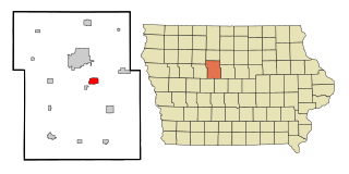
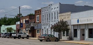
Otho is a city in Webster County, Iowa, United States. The population was 429 at the time of the 2020 census.

<span class="mw-page-title-main">Fort Atkinson, Iowa</span> City in Iowa, United States

Fort Atkinson is a city in Winneshiek County, Iowa, United States. The population was 312 at the time of the 2020 census. It is home to the historic Fort Atkinson State Preserve and hosts a large annual fur-trapper rendezvous each September. Fort Atkinson holds the largest regional hay auction every Wednesday.

<span class="mw-page-title-main">Claremont, Minnesota</span> City in Minnesota, United States

Claremont is a city in Dodge County, Minnesota, United States. The population was 548 at the 2010 census.

<span class="mw-page-title-main">Cascade, Montana</span> Town in Cascade County, Montana, United States

Cascade is a town in Cascade County, Montana, United States. The population was 600 at the 2020 census. It is part of the Great Falls, Montana Metropolitan Statistical Area, which in 2020 had a population of 84,414. Cascade was incorporated in 1911.

<span class="mw-page-title-main">Snyder, Nebraska</span> Village in Nebraska, United States

Snyder is a village in Dodge County, Nebraska, United States. The population was 300 at the 2010 census.

<span class="mw-page-title-main">Winslow, Nebraska</span> Village in Nebraska, United States

Winslow is a village in Dodge County, Nebraska, United States. The population was 103 at the 2010 census.

<span class="mw-page-title-main">Badger, Minnesota</span> City in Minnesota, United States

Badger is a city in Skagen Township of Roseau County, Minnesota, United States. The population was 375 at the 2010 census.

<span class="mw-page-title-main">Fort Ransom, North Dakota</span> City in North Dakota, United States

Fort Ransom is a city in Ransom County, North Dakota, United States. The population was 91 at the 2020 census. Fort Ransom was founded in 1880 with the first merchants arriving in 1878.

<span class="mw-page-title-main">Lake City, South Dakota</span> Town in South Dakota, United States

Lake City is a town in Marshall County, South Dakota, United States. The population was 45 at the 2020 census. Fort Sisseton Historic State Park, whose fort is listed on the National Register of Historic Places, is located nearby.

<span class="mw-page-title-main">Juneau, Wisconsin</span> City in Wisconsin, United States

Juneau is a city in Dodge County, Wisconsin, United States. The population was 2,658 at the 2020 census. It is the county seat of Dodge County.

<span class="mw-page-title-main">Kekoskee, Wisconsin</span> Village in Wisconsin, United States

Kekoskee is a village in Dodge County, Wisconsin, United States. The population was 161 at the 2010 census.

<span class="mw-page-title-main">Blooming Prairie, Minnesota</span> City in Minnesota, United States

Blooming Prairie is a city in Dodge and Steele counties in the U.S. state of Minnesota. The population was 1,996 at the 2010 census. Most of the city is located within Steele County; only a small part of the city extends into Dodge County.

<span class="mw-page-title-main">Verona, Wisconsin</span> City in Wisconsin, United States

Verona is a city in Dane County, Wisconsin, in the United States and is a suburb of Madison. The population was 14,030 at the 2020 census. The city is located ten miles southwest of downtown Madison within the Town of Verona. It is part of the Madison Metropolitan Statistical Area.

<span class="mw-page-title-main">Fort Dodge, Kansas</span> Unincorporated community in Ford County, Kansas

Fort Dodge is an unincorporated community in Grandview Township, Ford County, Kansas, United States. As of the 2020 census, the population of the community and nearby areas was 97. It is located on U.S. Route 400 5 miles (8 km) southeast of Dodge City. Fort Dodge has a post office with ZIP code 67843.

References

  1. "2020 U.S. Gazetteer Files". United States Census Bureau. Retrieved March 16, 2022.
  2. 1 2 "2020 Census State Redistricting Data". census.gov. United states Census Bureau. Retrieved August 12, 2021.
  3. Webster County Bicentennial Commission (1976). Webster's Prairies: The Township History of the County. Fort Dodge, Iowa. p. 114. OCLC   3618204.
  4. "US Gazetteer files: 2010, 2000, and 1990". United States Census Bureau. February 12, 2011. Retrieved April 23, 2011.
  5. "US Gazetteer files 2010". United States Census Bureau. Archived from the original on January 25, 2012. Retrieved May 11, 2012.
  6. "Census of Population and Housing". Census.gov. Retrieved June 4, 2015.
  7. "U.S. Census website". United States Census Bureau . Retrieved May 11, 2012.
  8. "U.S. Census website". United States Census Bureau . Retrieved January 31, 2008.
  9. "Fort Dodge" (PDF). Iowa Department of Education . Retrieved April 5, 2020.
  10. "Elementary Boundary Map Final" (PDF). Fort Dodge Community School District . Retrieved April 5, 2020. - See text note on the upper right hand corner of the screen.
  11. Thompson, Chad (January 30, 2018). "FDCSD board moves forward with boundary option No. 2". Fort Dodge Messenger . Retrieved April 5, 2020.