Cherry Grove, Washington

Last updated

Cherry Grove, Washington
Clark County Washington Incorporated and Unincorporated areas Cherry Grove Highlighted.svg
Location of Cherry Grove, Washington
Coordinates: 45°48′0″N122°34′45″W / 45.80000°N 122.57917°W / 45.80000; -122.57917 [1]
CountryUnited States
State Washington
County Clark
Area
  Total2.4 sq mi (6.3 km2)
  Land2.4 sq mi (6.3 km2)
  Water0.0 sq mi (0.0 km2)
Elevation
272 ft (83 m)
Population
 (2020)
  Total588
  Density240/sq mi (93/km2)
Time zone UTC-8 (Pacific (PST))
  Summer (DST) UTC-7 (PDT)
ZIP code
98604 [2]
Area code 360
FIPS code 53-12015 [3]
GNIS feature ID1510873 [4]

Cherry Grove is a census-designated place (CDP) in Clark County, Washington, United States. The population was 588 at the 2020 census. [5]

Contents

History

The name of Cherry Grove is linked to when plentiful wild cherry trees grew in the area. Most of the trees were planted in the 1800s, when Cherry Grove was mostly used for dairy and farming. [6]

Geography

Cherry Grove is located in central Clark County. The community is bordered to the southeast by the city of Battle Ground, to the east by Lewisville, and to the southwest by Dollars Corner.

According to the United States Census Bureau, the Cherry Grove CDP has a total area of 2.4 square miles (6.3 km2), all of it land, [7] and a reduction from the CDP's area in 2000 of 3.4 square miles (8.7 km2).

Demographics

Historical population
CensusPop.Note
2000 663
2010 546−17.6%
2020 5887.7%
US Decennial Census [8]

As of the census [3] of 2000, there were 663 people, 214 households, and 185 families residing in the CDP. The population density was 197.4 people per square mile (76.2/km2). There were 227 housing units at an average density of 67.6/sq mi (26.1/km2). The racial makeup of the CDP was 91.86% White, 1.96% African American, 0.45% Native American, 0.15% Asian, 3.17% from other races, and 2.41% from two or more races. Hispanic or Latino of any race were 5.28% of the population. 30.1% were of German, 17.6% American, 12.3% Finnish, 9.3% English and 6.2% Norwegian ancestry according to Census 2000.

There were 214 households, out of which 40.2% had children under the age of 18 living with them, 76.2% were married couples living together, 5.6% had a female householder with no husband present, and 13.1% were non-families. 10.3% of all households were made up of individuals, and 5.6% had someone living alone who was 65 years of age or older. The average household size was 3.10 and the average family size was 3.32.

In the CDP, the age distribution of the population shows 30.0% under the age of 18, 6.8% from 18 to 24, 26.4% from 25 to 44, 28.1% from 45 to 64, and 8.7% who were 65 years of age or older. The median age was 39 years. For every 100 females, there were 99.1 males. For every 100 females age 18 and over, there were 100.9 males.

The median income for a household in the CDP was $58,750, and the median income for a family was $64,000. Males had a median income of $40,750 versus $24,408 for females. The per capita income for the CDP was $20,760. None of the families and 1.7% of the population were living below the poverty line, including no under eighteens and none of those over 64.

Related Research Articles

<span class="mw-page-title-main">Grove City, Florida</span> Census-designated place in Florida, United States

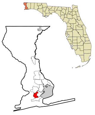
Grove City is an unincorporated community and census-designated place (CDP) in Charlotte County, Florida, United States. The population was 2,174 at the 2020 census. It is part of the Sarasota-Bradenton-Punta Gorda Combined Statistical Area.

<span class="mw-page-title-main">Myrtle Grove, Florida</span> Census-designated place in Florida, United States

Myrtle Grove is a census-designated place (CDP) in Escambia County, Florida, United States. The population was 15,870 at the 2010 census. It is part of the Pensacola–Ferry Pass–Brent Metropolitan Statistical Area.

Goodings Grove was a census-designated place in northern Will County, Illinois, United States. The population was 17,084 at the 2000 census. It is now a neighborhood of the village of Homer Glen, Illinois, which was incorporated in 2001.

<span class="mw-page-title-main">Ocean Grove, Massachusetts</span> CDP in Massachusetts, United States

Ocean Grove is a census-designated place (CDP) in the town of Swansea in Bristol County, Massachusetts, United States, on the north shore of Mount Hope Bay near the Cole River. The population was 2,811 at the 2010 census, and 2,904 as of the 2020 census.

<span class="mw-page-title-main">Cherry Hill Mall, New Jersey</span> Populated place in Camden County, New Jersey, US

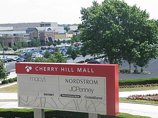
Cherry Hill Mall is an unincorporated community and census-designated place (CDP) located in Cherry Hill, in Camden County, in the U.S. state of New Jersey. As of the 2020 United States census, the CDP’s population was 14,805, its highest decennial count ever and an increase of 634 (+4.5%) from the 14,171 residents recorded at the 2010 census count, which in turn reflected an increase of 933 (+7.0%) from the 13,238 counted in the 2000 census. The CDP is home to the namesake Cherry Hill Mall shopping complex.

<span class="mw-page-title-main">Erlton-Ellisburg, New Jersey</span> Populated place in Camden County, New Jersey, US

Erlton-Ellisburg was an unincorporated community and census-designated place (CDP) located within Cherry Hill Township, in Camden County, in the U.S. state of New Jersey. As of the 2000 United States Census, the CDP's population was 8,168. The area comprises Erlton and Ellisburg, two neighborhoods in western Cherry Hill. As of the 2010 United States Census, the Erlton-Ellisburg CDP was discontinued and a portion of the old CDP was included in the new Ellisburg CDP.

<span class="mw-page-title-main">Cedar Grove, New Mexico</span> CDP in New Mexico, United States

Cedar Grove is a census-designated place (CDP) in Santa Fe County, New Mexico, United States. It is part of the Santa Fe, New Mexico Metropolitan Statistical Area. The population was 747 at the 2010 census. Cedar Grove was formerly a stage and freight stop. It has developed into a Santa Fe suburb. New Mexico "cedars" are abundant in the town.

<span class="mw-page-title-main">Neffs, Ohio</span> Census-designated place in Ohio, United States

Neffs is an unincorporated community and census-designated place in northwestern Pultney Township, Belmont County, Ohio, United States. The population was 878 at the 2020 census. It is part of the Wheeling metropolitan area.

<span class="mw-page-title-main">Cherry Grove, Ohio</span> Census-designated place in Ohio, United States

Cherry Grove is a census-designated place (CDP) in Anderson Township, Hamilton County, Ohio, United States. The population was 4,419 at the 2020 census.

<span class="mw-page-title-main">Cherry Tree, Oklahoma</span> Census-designated place in Oklahoma, USA

Cherry Tree is a census-designated place (CDP) in Adair County, Oklahoma, United States. The population was 883 at the 2010 census, a decline of 26.5 percent from the figure of 1,202 recorded in 2000.

<span class="mw-page-title-main">Shady Grove, Cherokee County, Oklahoma</span> Census-designated place in Oklahoma, United States

Shady Grove is an unincorporated community and census-designated place (CDP) in Cherokee County, Oklahoma, United States. The population was 556 at the 2010 census. This is not to be confused with the similarly-named Shady Grove in McIntosh County, or the Shady Grove in Pawnee County.

<span class="mw-page-title-main">Eyers Grove, Pennsylvania</span> Census-designated place in Pennsylvania, United States

Eyers Grove is a census-designated place in Columbia County, Pennsylvania, United States. It is part of Northeastern Pennsylvania. The population was 102 at the 2020 census. It is part of the Bloomsburg-Berwick micropolitan area.

<span class="mw-page-title-main">Barberton, Washington</span> Census-designated place in Washington, United States

Barberton is a census-designated place (CDP) in Clark County, Washington, United States. The population was 8,567 at the 2020 census.

<span class="mw-page-title-main">Dollars Corner, Washington</span> Census-designated place in Washington, United States

Dollars Corner is a census-designated place (CDP) in Clark County, Washington, United States. The population was 1,246 at the 2020 census, up from 1,108 at the 2010 census.

<span class="mw-page-title-main">Five Corners, Washington</span> Census-designated place in Washington, United States

Five Corners is a census-designated place (CDP) in Clark County, Washington, United States. The population was 20,973 at the 2020 census.

<span class="mw-page-title-main">Lewisville, Washington</span> Census-designated place in Washington, United States

Lewisville is a census-designated place (CDP) in Clark County, Washington, United States. The population was 1,860 at the 2020 census.

<span class="mw-page-title-main">Mill Plain, Washington</span> Unincorporated community in Clark County, Washington

Mill Plain is an unincorporated area in Clark County, Washington, United States. At the 2000 census it was defined as a census-designated place (CDP) and had a population of 7,400. The area was not listed as a CDP for the 2010 census.

<span class="mw-page-title-main">Minnehaha, Washington</span> Census-designated place in Washington, United States

Minnehaha is a census-designated place (CDP) in Clark County, Washington, United States. The population was 11,871 at the 2020 census.

<span class="mw-page-title-main">Salmon Creek, Washington</span> Census-designated place in Washington, United States

Salmon Creek is a census-designated place (CDP) in Clark County, Washington, United States. The population was 21,293 at the 2020 census.

<span class="mw-page-title-main">Walnut Grove, Washington</span> Census-designated place in Washington, United States

Walnut Grove is a census-designated place (CDP) in Clark County, Washington, United States. The population was 9,790 at the 2010 census, up from 7,164 at the 2000 census.

References

  1. "US Gazetteer files: 2010, 2000, and 1990". United States Census Bureau. February 12, 2011. Retrieved April 23, 2011.
  2. "Cherry Grove WA ZIP Code". zipdatamaps.com. 2023. Retrieved June 16, 2023.
  3. 1 2 "U.S. Census website". United States Census Bureau . Retrieved January 31, 2008.
  4. "US Board on Geographic Names". United States Geological Survey. October 25, 2007. Retrieved January 31, 2008.
  5. "Census Bureau profile: Cherry Grove, Washington". United States Census Bureau. May 2023. Retrieved May 8, 2024.
  6. "Cherry Grove - Clark County: A history". Clark County History. Retrieved May 31, 2023.
  7. "Geographic Identifiers: 2010 Demographic Profile Data (G001): Cherry Grove CDP, Washington". U.S. Census Bureau, American Factfinder. Retrieved August 28, 2015.[ dead link ]
  8. "US Gazetteer files: 2010, 2000, and 1990". United States Census Bureau. February 12, 2011. Retrieved April 23, 2011.