Lewisville, Washington

Last updated

Lewisville, Washington
Clark County Washington Incorporated and Unincorporated areas Lewisville Highlighted.svg
Location of Lewisville, Washington
Coordinates: 45°48′33″N122°31′30″W / 45.80917°N 122.52500°W / 45.80917; -122.52500 [1]
CountryUnited States
State Washington
County Clark
Area
  Total5.6 sq mi (14.6 km2)
  Land5.6 sq mi (14.5 km2)
  Water0.04 sq mi (0.1 km2)
Elevation
413 ft (126 m)
Population
 (2020)
  Total1,860
  Density330/sq mi (130/km2)
Time zone UTC-8 (Pacific (PST))
  Summer (DST) UTC-7 (PDT)
ZIP code
98604 [2]
Area code 360
FIPS code 53-39212 [3]
GNIS feature ID1852948 [4]

Lewisville is a census-designated place (CDP) in Clark County, Washington, United States. The population was 1,860 at the 2020 census. [5]

Contents

Geography

Lewisville is located in central Clark County and is bordered to the southeast by Venersborg, to the southwest by the city of Battle Ground, and for a small distance on the west by Cherry Grove.

According to the United States Census Bureau, the Lewisville CDP has a total area of 5.6 square miles (14.6 km2), of which 5.6 square miles (14.5 km2) is land and 0.04 square miles (0.1 km2), or 0.70%, is water. [6]

Demographics

Historical population
CensusPop.Note
2000 1,688
2010 1,7222.0%
2020 1,8608.0%
Sources: [3] [6] [5]

As of the census [3] of 2000, there were 1,688 people, 552 households, and 476 families residing in the CDP. The population density was 276.9 people per square mile (106.8/km2). There were 563 housing units at an average density of 92.4/sq mi (35.6/km2). The racial makeup of the CDP was 95.97% White, 0.24% African American, 0.53% Native American, 0.41% Asian, 0.36% Pacific Islander, 1.54% from other races, and 0.95% from two or more races. Hispanic or Latino of any race were 1.78% of the population. 19.5% were of German, 13.9% English, 8.2% Norwegian, 7.5% Irish, 7.5% American, 6.8% Swedish and 5.9% Finnish ancestry according to Census 2000.

There were 552 households, out of which 39.9% had children under the age of 18 living with them, 79.2% were married couples living together, 4.9% had a female householder with no husband present, and 13.6% were non-families. 10.0% of all households were made up of individuals, and 3.8% had someone living alone who was 65 years of age or older. The average household size was 3.06 and the average family size was 3.27.

In the CDP, the age distribution of the population shows 29.6% under the age of 18, 7.0% from 18 to 24, 25.1% from 25 to 44, 29.6% from 45 to 64, and 8.7% who were 65 years of age or older. The median age was 39 years. For every 100 females, there were 102.2 males. For every 100 females age 18 and over, there were 98.8 males.

The median income for a household in the CDP was $65,221, and the median income for a family was $62,031. Males had a median income of $48,816 versus $38,068 for females. The per capita income for the CDP was $23,175. About 2.0% of families and 1.1% of the population were below the poverty line, including none of those under age 18 and 9.1% of those age 65 or over.

Related Research Articles

<span class="mw-page-title-main">Moores Mill, Alabama</span> Census-designated place in Alabama, United States

Moores Mill is an unincorporated community and census-designated place (CDP) in Madison County, Alabama, United States, and is included in the Huntsville-Decatur Combined Statistical Area. The population was 6,729 at the 2020 census, up from 5,682 at the 2010 census.

<span class="mw-page-title-main">Bayview-Montalvin, California</span> Former CDP in California, United States

Bayview-Montalvin is a former census-designated place (CDP) in Contra Costa County, California, United States. The population was 5,004 at the 2000 census.

<span class="mw-page-title-main">Riverdale, California</span> Census-designated place in California, United States

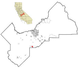
Riverdale is a census-designated place (CDP) in Fresno County, California, United States. The population was 3,153 at the 2010 census, up from 2,416 at the 2000 census. Riverdale is located 23 miles (37 km) south of Fresno, at an elevation of 223 ft (68 m).

<span class="mw-page-title-main">South Dos Palos, California</span> Census-designated place in California, US

South Dos Palos is an unincorporated community and census-designated place (CDP) in Merced County, California, United States. It is located 2 miles (3 km) southwest of Dos Palos at an elevation of 118 feet (36 m). The population was 1,747 at the 2020 census, up from 1,620 at the 2010 census.

<span class="mw-page-title-main">St. Augustine Shores, Florida</span> CDP in Florida, United States

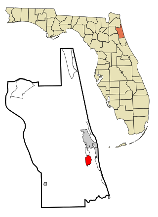
St. Augustine Shores is a census-designated place (CDP) in St. Johns County, Florida, United States. As of the 2000 census, the CDP population was 4,922.

<span class="mw-page-title-main">Escatawpa, Mississippi</span> Census-designated place in Mississippi, United States

Escatawpa is an unincorporated community and census-designated place (CDP) in Jackson County, Mississippi, United States. It is part of the Pascagoula Metropolitan Statistical Area. The population was 3,254 at the 2020 census.

<span class="mw-page-title-main">Brass Castle, New Jersey</span> Populated place in Warren County, New Jersey, US

Brass Castle is an unincorporated community and census-designated place (CDP) located within Washington Township, in Warren County, in the U.S. state of New Jersey. As of the 2010 United States Census, the CDP's population was 1,555.

<span class="mw-page-title-main">Bent Creek, Buncombe County, North Carolina</span> Census-designated place in North Carolina, United States

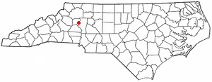
Bent Creek is a census-designated place (CDP) in Buncombe County, North Carolina, United States. The population was 1,287 at the 2010 census. The Bent Creek area has mountain bike trails within the Pisgah National Forest.

<span class="mw-page-title-main">Lowesville, North Carolina</span> Census-designated place in North Carolina, United States

Lowesville is a census-designated place (CDP) in Lincoln County, North Carolina, United States. The population was 2,945 at the 2010 census, up from 1,440 in 2000.

<span class="mw-page-title-main">Lewisville, Ohio</span> Village in Ohio, United States

Lewisville is a village in Monroe County, Ohio, United States. The population was 184 at the 2020 census.

Meridian is a former census-designated place (CDP) in Stephens County, Oklahoma, United States. The population was 1,485 at the 2000 census. As of the 2020 census, the area, plus land to the north, was part of the Sunray CDP.

Northcliffe is a former census-designated place (CDP) in Guadalupe County, Texas, United States. The population was 1,819 at the 2000 census. The area is now part of the city of Schertz and did not have its population recorded separately at the 2010 census. It is part of the San Antonio Metropolitan Statistical Area.

<span class="mw-page-title-main">Amboy, Washington</span> Census-designated place in Washington, United States

Amboy is a census-designated place (CDP) in Clark County, Washington, United States. The population was 1,838 at the 2020 census, up from 1,608 at the 2010 census. It is located 33 miles northeast of Vancouver which is part of the Portland-Vancouver metropolitan area.

<span class="mw-page-title-main">Cherry Grove, Washington</span> Census-designated place in Washington, United States

Cherry Grove is a census-designated place (CDP) in Clark County, Washington, United States. The population was 588 at the 2020 census.

<span class="mw-page-title-main">James Town, Wyoming</span> CDP in Wyoming, United States

James Town is a census-designated place (CDP) in Sweetwater County, Wyoming, United States. The population was 536 at the 2010 census.

North Rock Springs is a census-designated place (CDP) in Sweetwater County, Wyoming, United States. The population was 2,439 at the 2020 census.

<span class="mw-page-title-main">Stony Point, North Carolina</span> Census-designated place in North Carolina, United States

Stony Point is a census-designated place (CDP) in Alexander and Iredell counties in the U.S. state of North Carolina. The population was 1,317 at the 2010 census. It is part of the Hickory–Lenoir–Morganton Metropolitan Statistical Area.

<span class="mw-page-title-main">Loveland Park, Ohio</span> Census-designated place in Ohio, United States

Loveland Park is a census-designated place (CDP) located in Symmes Township, Hamilton County and Deerfield Township, Warren County, in the southwestern part of the U.S. state of Ohio. The CDP is named after the city of Loveland. The population was 1,737 at the 2020 census.

<span class="mw-page-title-main">Amenia (CDP), New York</span> Hamlet in the state of New York, United States

Amenia is a hamlet and census-designated place (CDP) in Dutchess County, New York, United States. The population was 725 at the 2020 census. It is part of the Poughkeepsie–Newburgh–Middletown, NY Metropolitan Statistical Area as well as the larger New York–Newark–Bridgeport, NY-NJ-CT-PA Combined Statistical Area.

<span class="mw-page-title-main">Boothbay Harbor (CDP), Maine</span> Census-designated place in Maine, United States

Boothbay Harbor is a census-designated place (CDP) comprising the densely populated center of the town of Boothbay Harbor in Lincoln County, Maine, United States. The population was 1,086 at the 2010 census, down from 1,237 at the 2000 census.

References

  1. "US Gazetteer files: 2010, 2000, and 1990". United States Census Bureau. February 12, 2011. Retrieved April 23, 2011.
  2. "Lewisville WA ZIP Code". zipdatamaps.com. 2023. Retrieved June 16, 2023.
  3. 1 2 3 "U.S. Census website". United States Census Bureau . Retrieved January 31, 2008.
  4. "US Board on Geographic Names". United States Geological Survey. October 25, 2007. Retrieved January 31, 2008.
  5. 1 2 "Census Bureau profile: Lewisville, Washington". United States Census Bureau. May 2023. Retrieved May 8, 2024.
  6. 1 2 "Geographic Identifiers: 2010 Demographic Profile Data (G001): Lewisville CDP, Washington". U.S. Census Bureau, American Factfinder. Retrieved September 3, 2015.[ dead link ]