Salmon Creek, Washington

Last updated

Salmon Creek, Washington
Sunrise over Salmon Creek Regional Park.jpg
Sunrise over Salmon Creek Regional Park
Clark County Washington Incorporated and Unincorporated areas Salmon Creek Highlighted.svg
Location of Salmon Creek, Washington
Coordinates: 45°42′18″N122°39′41″W / 45.70500°N 122.66139°W / 45.70500; -122.66139 [1]
CountryUnited States
State Washington
County Clark
Area
  Total6.3 sq mi (16.4 km2)
  Land6.3 sq mi (16.4 km2)
  Water0.0 sq mi (0.0 km2)
Elevation
164 ft (50 m)
Population
 (2020)
  Total21,293
  Density3,400/sq mi (1,300/km2)
Time zone UTC-8 (Pacific (PST))
  Summer (DST) UTC-7 (PDT)
FIPS code 53-61000 [2]
GNIS feature ID1512637 [3]

Salmon Creek is a census-designated place (CDP) in Clark County, Washington, United States. The population was 21,293 at the 2020 census. [4]

Contents

Geography

Salmon Creek is located in southwestern Clark County. The community is bordered to the northeast by Mount Vista, to the east by Barberton, to the southeast by Walnut Grove, to the south by Hazel Dell, to the southwest by Lake Shore, and to the west by Felida. Downtown Vancouver is 6 miles (10 km) to the south.

According to the United States Census Bureau, the Salmon Creek CDP has a total area of 6.3 square miles (16.4 km2), all of it land. [5]

Demographics

Historical population
CensusPop.Note
2000 16,767
2010 19,68617.4%
2020 21,2938.2%
Sources: [2] [5] [4]

As of the census [2] of 2000, there were 16,767 people, 6,439 households, and 4,642 families residing in the CDP. The population density was 2,673.6 inhabitants per square mile (1,032.3/km2). There were 6,756 housing units at an average density of 1,077.3 per square mile (415.9/km2). The racial makeup of the CDP was 91.32% White, 1.26% African American, 0.54% Native American, 2.49% Asian, 0.14% Pacific Islander, 1.34% from other races, and 2.92% from two or more races. Hispanic or Latino of any race were 4.81% of the population. 18.0% were of German, 10.9% English, 10.9% Irish, 10.0% American and 6.3% Norwegian ancestry according to Census 2000.

There were 6,439 households, out of which 37.7% had children under the age of 18 living with them, 57.9% were married couples living together, 10.4% had a female householder with no husband present, and 27.9% were non-families. 22.3% of all households were made up of individuals, and 6.7% had someone living alone who was 65 years of age or older. The average household size was 2.60 and the average family size was 3.04.

In the CDP, the age distribution of the population shows 28.1% under the age of 18, 7.5% from 18 to 24, 28.4% from 25 to 44, 26.6% from 45 to 64, and 9.4% who were 65 years of age or older. The median age was 37 years. For every 100 females, there were 95.3 males. For every 100 females age 18 and over, there were 92.2 males.

The median income for a household in the CDP was $53,917, and the median income for a family was $62,989. Males had a median income of $48,766 versus $31,186 for females. The per capita income for the CDP was $23,673. About 6.6% of families and 8.4% of the population were below the poverty line, including 11.8% of those under age 18 and 3.5% of those age 65 or over.

Related Research Articles

<span class="mw-page-title-main">Fox River, Alaska</span> Census-designated place in Alaska, United States

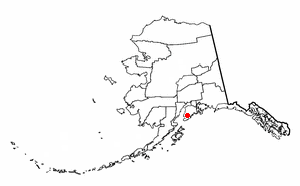
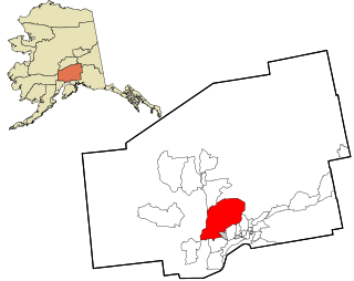
Fox River is a census-designated place (CDP) in Kenai Peninsula Borough, Alaska, United States. At the 2010 census the population was 685, up from 616 in 2000. It was first reported by the U.S. Geological Survey in 1895. The Fox River, which flows by the CDP, might have been named for Theodore Fox, a local mining magnate.

<span class="mw-page-title-main">Willow, Alaska</span> CDP in Alaska, United States

Willow is a census-designated place (CDP) in the Matanuska-Susitna Borough in the U.S. state of Alaska. Located 26 miles northwest from Wasilla along the George Parks Highway, it is part of the Anchorage, Alaska Metropolitan Statistical Area. At the 2020 census the population was 2,196, up from 2,102 in 2010.

<span class="mw-page-title-main">South Wallins, Kentucky</span> Census-designated place in Kentucky, United States

South Wallins is an unincorporated community and census-designated place (CDP) in Harlan County, Kentucky, United States. The population was 859 at the 2010 census, down from 996 at the 2000 census.

<span class="mw-page-title-main">Riviera Beach, Maryland</span> Census-designated place in Maryland, United States

Riviera Beach is a census-designated place in Anne Arundel County, Maryland, United States. The population was 12,677 at the 2010 U.S. census.

<span class="mw-page-title-main">Canada Creek Ranch, Michigan</span> Census-designated place in Michigan, United States

Canada Creek Ranch is an unincorporated community in Montmorency Township, Montmorency County, in the U.S. state of Michigan. It is a census-designated place (CDP) used for statistical purposes. The population was 258 at the 2020 census, down from 304 in 2010.

<span class="mw-page-title-main">Beaver Creek, Montana</span> Census-designated place in Montana, United States

Beaver Creek is a census-designated place (CDP) in Hill County, Montana, United States. The population was 271 at the 2010 census.

<span class="mw-page-title-main">Forest Oaks, North Carolina</span> Census-designated place in North Carolina, United States

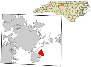
Forest Oaks is a census-designated place (CDP) in Guilford County, North Carolina, United States. The population was 3,890 as of the 2010 census, up from 3,241 in 2000.

<span class="mw-page-title-main">Millers Creek, North Carolina</span> CDP in North Carolina, United States

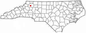
Millers Creek is a census-designated place (CDP) in Wilkes County, North Carolina, United States. The population was 2,112 at the 2010 census. West Wilkes High School, one of the four public high schools in Wilkes County, is located in Millers Creek.

<span class="mw-page-title-main">Grandview, Hamilton County, Ohio</span> Census-designated place in Ohio, United States

Grandview is a census-designated place (CDP) in Hamilton County, Ohio, United States. The population was 1,312 at the 2020 census.

<span class="mw-page-title-main">Pigeon Creek, Ohio</span> CDP in Ohio, United States

Pigeon Creek is a census-designated place (CDP) in Summit County, Ohio, United States. The population was 886 at the 2020 census. It is part of the Akron metropolitan statistical area.

<span class="mw-page-title-main">Clarence, Pennsylvania</span> Census-designated place in Pennsylvania, United States

Clarence is a census-designated place (CDP) in Centre County, Pennsylvania, United States. It is part of the State College, Pennsylvania Metropolitan Statistical Area. The population was 626 at the 2010 census.

<span class="mw-page-title-main">Canadohta Lake, Pennsylvania</span> Census-designated place in Pennsylvania, United States

Canadohta Lake is a census-designated place (CDP) in Crawford County, Pennsylvania, United States. The population was 503 at the 2020 census.

<span class="mw-page-title-main">Spring Creek, South Dakota</span> CDP in South Dakota, United States

Spring Creek is a census-designated place (CDP) in Todd County, South Dakota, United States. The population was 236 at the 2020 census.

<span class="mw-page-title-main">Gloucester Point, Virginia</span> Census-designated place in Virginia, United States

Gloucester Point is a census-designated place (CDP) in Gloucester County, Virginia, United States. The population was 9,402 at the 2010 census. It is home to the College of William & Mary's Virginia Institute of Marine Science, a graduate school for the study of oceanography.

<span class="mw-page-title-main">Barberton, Washington</span> Census-designated place in Washington, United States

Barberton is a census-designated place (CDP) in Clark County, Washington, United States. The population was 8,567 at the 2020 census.

<span class="mw-page-title-main">Martha Lake, Washington</span> CDP in Washington, United States

Martha Lake is a census-designated place (CDP) in Snohomish County, Washington, United States. The population was 21,129 at the 2020 census. It lies west of Mill Creek and northeast of Lynnwood, near the lake of the same name.

<span class="mw-page-title-main">May Creek, Washington</span> CDP in Washington, United States

May Creek is a census-designated place (CDP) in Snohomish County, Washington, United States. The population was 849 at the 2020 census.

<span class="mw-page-title-main">Woods Creek, Washington</span> CDP in Washington, United States

Woods Creek is a census-designated place (CDP) in Snohomish County, Washington, United States. The population was 6,017 at the 2020 census.

<span class="mw-page-title-main">Switzer, West Virginia</span> Census-designated place in West Virginia, United States

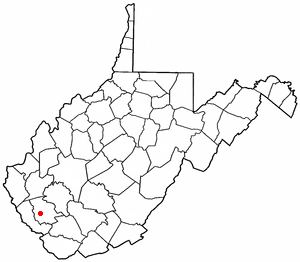
Switzer is an unincorporated community and census-designated place (CDP) in Logan County, West Virginia, United States. The CDP includes the neighboring unincorporated community of Micco. The total CDP population was 595 at the 2010 census.

<span class="mw-page-title-main">Gilbert Creek, West Virginia</span> CDP in West Virginia, United States

Gilbert Creek is a census-designated place (CDP) in Mingo County, West Virginia, United States. The population was 1,090 at the 2010 census. The community takes its name from nearby Gilbert Creek.

References

  1. "US Gazetteer files: 2010, 2000, and 1990". United States Census Bureau. February 12, 2011. Retrieved April 23, 2011.
  2. 1 2 3 "U.S. Census website". United States Census Bureau . Retrieved January 31, 2008.
  3. "US Board on Geographic Names". United States Geological Survey. October 25, 2007. Retrieved January 31, 2008.
  4. 1 2 "Census Bureau profile: Salmon Creek, Washington". United States Census Bureau. May 2023. Retrieved May 8, 2024.
  5. 1 2 "Geographic Identifiers: 2010 Demographic Profile Data (G001): Salmon Creek CDP, Washington". U.S. Census Bureau, American Factfinder. Retrieved September 8, 2015.[ dead link ]