Five Corners, Washington

Last updated

Five Corners, Washington
Clark County Washington Incorporated and Unincorporated areas Five Corners Highlighted.svg
Location of Five Corners, Washington
Coordinates: 45°40′56″N122°34′10″W / 45.68222°N 122.56944°W / 45.68222; -122.56944 [1]
CountryUnited States
State Washington
County Clark
Area
  Total5.9 sq mi (15.3 km2)
  Land5.9 sq mi (15.3 km2)
  Water0.0 sq mi (0.0 km2)
Elevation
213 ft (65 m)
Population
 (2010)
  Total18,159
  Density3,076/sq mi (1,187.7/km2)
Time zone UTC-8 (Pacific (PST))
  Summer (DST) UTC-7 (PDT)
FIPS code 53-24188 [2]
GNIS feature ID1867611 [3]

Five Corners is a census-designated place (CDP) in Clark County, Washington, United States. The population was 20,973 at the 2020 census. [4]

Contents

Geography

Five Corners is located in southern Clark County. The community is bordered by Walnut Grove to the southwest, Barberton to the northwest, Brush Prairie to the north, Orchards to the east, and the city of Vancouver to the south. Interstate 205 forms the southwest edge of the CDP, and Washington State Route 503 forms the eastern edge. Downtown Vancouver is 8 miles (13 km) to the southwest.

According to the United States Census Bureau, the Five Corners CDP has a total area of 5.9 square miles (15.3 km2), all of it land. [5]

Demographics

Historical population
CensusPop.Note
1990 6,776
2000 12,20780.2%
2010 18,15948.8%
2020 20,97315.5%
Sources: [6] [5]

As of the census [2] of 2000, there were 12,207 people, 4,100 households, and 3,222 families residing in the CDP. The population density was 1,977.8 people per square mile (763.9/km2). There were 4,306 housing units at an average density of 697.7/sq mi (269.5/km2). The racial makeup of the CDP was 88.65% White, 1.65% African American, 0.88% Native American, 3.99% Asian, 0.62% Pacific Islander, 1.52% from other races, and 2.70% from two or more races. Hispanic or Latino of any race were 4.14% of the population. 19.5% were of German, 10.0% American, 9.9% English and 9.0% Irish ancestry according to Census 2000.

There were 4,100 households, out of which 40.6% had children under the age of 18 living with them, 63.5% were married couples living together, 10.3% had a female householder with no husband present, and 21.4% were non-families. 15.1% of all households were made up of individuals, and 4.0% had someone living alone who was 65 years of age or older. The average household size was 2.96 and the average family size was 3.29.

In the CDP, the age distribution of the population shows 30.2% under the age of 18, 8.0% from 18 to 24, 32.4% from 25 to 44, 23.5% from 45 to 64, and 5.9% who were 65 years of age or older. The median age was 33 years. For every 100 females, there were 99.5 males. For every 100 females age 18 and over, there were 98.5 males.

The median income for a household in the CDP was $51,688, and the median income for a family was $55,302. Males had a median income of $41,200 versus $27,630 for females. The per capita income for the CDP was $19,570. About 3.1% of families and 5.7% of the population were below the poverty line, including 5.9% of those under age 18 and 4.7% of those age 65 or over.

Related Research Articles

Kaibab is an unincorporated community and census-designated place (CDP) in Mohave County, Arizona, United States. It is within the Kaibab Indian Reservation. The population of the CDP was 140 at the 2020 census.

<span class="mw-page-title-main">South Duxbury, Massachusetts</span> Census-designated place in Massachusetts, United States

South Duxbury is a census-designated place (CDP) in the town of Duxbury in Plymouth County, Massachusetts, United States. The population was 3,360 at the 2010 census.

<span class="mw-page-title-main">Robin Glen-Indiantown, Michigan</span> Census-designated place & unincorporated community in Michigan, United States

Robin Glen-Indiantown is a census-designated place (CDP) in Buena Vista Charter Township, Saginaw County in the U.S. state of Michigan. The CDP is used for statistical purposes and has no legal status as an incorporated municipality. The population was 1,158 at the 2000 census.

<span class="mw-page-title-main">Vinco, Pennsylvania</span> Census-designated place in Pennsylvania, United States

Vinco is an unincorporated community and census-designated place (CDP) in Jackson Township, Cambria County, in the U.S. state of Pennsylvania. The population was 1,305 at the 2010 census.

<span class="mw-page-title-main">Dunnstown, Pennsylvania</span> Census-designated place in Pennsylvania, United States

Dunnstown is a census-designated place (CDP) in Clinton County, Pennsylvania, United States. The population was 1,360 at the 2010 census.

<span class="mw-page-title-main">Idylwood, Virginia</span> Census-designated place in Virginia, United States

Idylwood is a census-designated place (CDP) in Fairfax County, Virginia, United States. The population was 17,954 as of the 2020 census. It originally developed as a suburban community along the route of the Washington and Old Dominion Railroad, and later along Virginia State Route 7. The construction of the Capital Beltway in the 1960s, and I-66 and the Orange Line of the Washington Metrorail system in the 1980s, as well as the concurrent development of nearby Tysons Corner into Washington's leading suburban business district, led to the development of several apartment, townhouse, and small-lot single-family housing complexes, as well as the high-rise Idylwood Towers condominium, in the portion of Idylwood lying to the north of I-66. The area to the south of I-66 remains primarily large-lot single-family.

<span class="mw-page-title-main">Merrifield, Virginia</span> Census-designated place in Virginia, United States

Merrifield is a census-designated place (CDP) in Fairfax County, Virginia, United States. The population was 20,488 at the 2020 census.

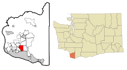
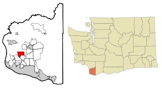
Westlake Corner is a census-designated place in Franklin County, Virginia, United States. The population was 1,553 at the 2020 census up fro 976 at the 2010 census. It is part of the Roanoke Metropolitan Statistical Area.

<span class="mw-page-title-main">Barberton, Washington</span> Census-designated place in Washington, United States

Barberton is a census-designated place (CDP) in Clark County, Washington, United States. The population was 8,567 at the 2020 census.

<span class="mw-page-title-main">Brush Prairie, Washington</span> Census-designated place in Washington, United States

Brush Prairie is a census-designated place (CDP) in Clark County, Washington, United States. The population was 2,738 at the 2020 census, up from 2,384 at the 2000 census.

<span class="mw-page-title-main">Cherry Grove, Washington</span> Census-designated place in Washington, United States

Cherry Grove is a census-designated place (CDP) in Clark County, Washington, United States. The population was 588 at the 2020 census.

<span class="mw-page-title-main">Mount Vista, Washington</span> Census-designated place in Washington, United States

Mount Vista is a census-designated place (CDP) in Clark County, Washington, United States. It includes the Vancouver campus of Washington State University. The population of Mount Vista was 10,051 at the 2020 census.

<span class="mw-page-title-main">Orchards, Washington</span> Census-designated place in Washington, United States

Orchards is a census-designated place (CDP) in Clark County, Washington, United States. The population was 27,729 at the 2020 census.

<span class="mw-page-title-main">Walnut Grove, Washington</span> Census-designated place in Washington, United States

Walnut Grove is a census-designated place (CDP) in Clark County, Washington, United States. The population was 9,790 at the 2010 census, up from 7,164 at the 2000 census.

<span class="mw-page-title-main">Lakeview, Washington</span> Census-designated place in Washington, United States

Lakeview is a census-designated place (CDP) in Grant County, Washington, United States. The population was 915 at the 2010 census, up from 797 at the 2000 census. The community is referred to as Lakeview Park on topographic maps and by locals.

<span class="mw-page-title-main">Lakeland North, Washington</span> Census-designated place in Washington, United States

Lakeland North is a census-designated place (CDP) in King County, Washington, United States. The population was 13,663 at the 2020 census. Part of the community was annexed into neighboring Auburn in 2008.

<span class="mw-page-title-main">Riverpoint, Washington</span> Census-designated place in Washington, United States

Riverpoint is an unincorporated community and census-designated place (CDP) in east King County, Washington, United States. As of the 2020 census, it had a population of 774. At the 2010 census, the area was listed as the Tanner CDP and had a population of 1,018 over a larger area.

<span class="mw-page-title-main">Tanglewilde, Washington</span> CDP in Washington, United States

Tanglewilde is a census-designated place (CDP) in Thurston County, Washington, United States, part of the Urban Growth Area of the city of Lacey.

<span class="mw-page-title-main">Satus, Washington</span> CDP in Washington, United States

Satus is a census-designated place (CDP) in Yakima County, Washington, United States, located on the eastern corner of the Yakama Indian Reservation. The population was 746 at the 2000 census. It is southwest from the Toppenish National Wildlife Refuge. The community was not recognized in the 2010 census. The area was first settled and established as a post office location in 1890.

<span class="mw-page-title-main">Madawaska (CDP), Maine</span> Census-designated place in Maine, United States

Madawaska is a census-designated place (CDP) comprising the main village within the town of Madawaska in Aroostook County, Maine, United States. The population of the CDP was 2,967 at the 2010 census, out of a population of 4,035 for the entire town.

References

  1. "US Gazetteer files: 2010, 2000, and 1990". United States Census Bureau. February 12, 2011. Retrieved April 23, 2011.
  2. 1 2 "U.S. Census website". United States Census Bureau . Retrieved January 31, 2008.
  3. "US Board on Geographic Names". United States Geological Survey. October 25, 2007. Retrieved January 31, 2008.
  4. "Census Bureau profile: Five Corners, Washington". United States Census Bureau. May 2023. Retrieved May 8, 2024.
  5. 1 2 "Geographic Identifiers: 2010 Demographic Profile Data (G001): Five Corners CDP, Washington". U.S. Census Bureau, American Factfinder. Retrieved August 31, 2015.[ dead link ]
  6. "CENSUS OF POPULATION AND HOUSING (17902000)". U.S. Census Bureau . Retrieved July 31, 2010.