Lake Shore, Washington

Last updated

Lake Shore, Washington
Clark County Washington Incorporated and Unincorporated areas Lake Shore Highlighted.svg
Location of Lake Shore, Washington
Coordinates: 45°41′26″N122°41′28″W / 45.69056°N 122.69111°W / 45.69056; -122.69111 [1]
CountryUnited States
State Washington
County Clark
Area
  Total1.64 sq mi (4.25 km2)
  Land1.64 sq mi (4.25 km2)
  Water0.0 sq mi (0.0 km2)
Elevation
223 ft (68 m)
Population
 (2020)
  Total7,056
  Density4,300/sq mi (1,700/km2)
Time zone UTC-8 (Pacific (PST))
  Summer (DST) UTC-7 (PDT)
FIPS code 53-37830 [2]
GNIS feature ID1867617 [3]

Lake Shore is a census-designated place (CDP) in Clark County, Washington, United States. The population was 7,056 at the 2020 census. [4]

Contents

Based on per capita income, one of the more reliable measures of affluence, Lake Shore ranks 124th of 614 areas in the state of Washington to be ranked.

Geography

Lake Shore is located in southwestern Clark County on the east side of Vancouver Lake. The community is bordered to the northwest by Felida, to the northeast by Salmon Creek, to the southeast by Hazel Dell, and to the south by the city of Vancouver.

According to the United States Census Bureau, the Lake Shore CDP has a total area of 1.64 square miles (4.25 km2), all of it land. [5]

Demographics

Historical population
CensusPop.Note
2000 6,670
2010 6,571−1.5%
2020 7,0567.4%
Sources: [2] [5] [4]

As of the census of 2000, there were 6,670 people, 2,355 households, and 1,940 families residing in the CDP. The population density was 4,110.1 inhabitants per square mile (1,586.9/km2). There were 2,415 housing units at an average density of 1,488.2 per square mile (574.6/km2). The racial makeup of the CDP was 92.38% White, 1.20% African American, 0.72% Native American, 2.46% Asian, 0.07% Pacific Islander, 0.67% from other races, and 2.49% from two or more races. Hispanic or Latino of any race were 2.91% of the population. 21.7% were of German, 11.9% English, 8.8% Irish, 6.8% Norwegian and 5.6% American ancestry according to Census 2000.

There were 2,355 households, out of which 36.4% had children under the age of 18 living with them, 70.6% were married couples living together, 8.6% had a female householder with no husband present, and 17.6% were non-families. 13.2% of all households were made up of individuals, and 5.0% had someone living alone who was 65 years of age or older. The average household size was 2.83 and the average family size was 3.09.

In the CDP, the age distribution of the population shows 27.7% under the age of 18, 6.4% from 18 to 24, 26.1% from 25 to 44, 29.4% from 45 to 64, and 10.4% who were 65 years of age or older. The median age was 39 years. For every 100 females, there were 100.3 males. For every 100 females age 18 and over, there were 96.9 males.

The median income for a household in the CDP was $62,476, and the median income for a family was $66,217. Males had a median income of $48,716 versus $35,300 for females. The per capita income for the CDP was $27,008. About 3.6% of families and 3.3% of the population were below the poverty line, including 3.9% of those under age 18 and 6.4% of those age 65 or over.

Related Research Articles

Fox Lake Hills is an unincorporated community and census-designated place (CDP) in Lake Villa Township, Lake County, Illinois, United States. Per the 2020 census, the population was 2,684.

<span class="mw-page-title-main">Lakeside, Montana</span> Unincorporated community in Montana, United States

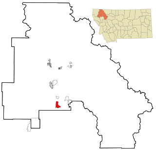
Lakeside is an unincorporated area and census-designated place (CDP) in Flathead County, Montana, United States. The population was 2,705 at the 2020 census, up from 2,669 in 2010.

<span class="mw-page-title-main">Pine Ridge, Citrus County, Florida</span> Census-designated place in Florida, US

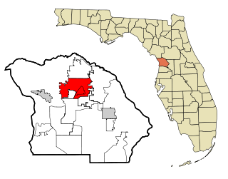
Pine Ridge is an unincorporated community and census-designated place (CDP) in Citrus County, Florida, United States. The population was 9,598 at the 2010 census, up from 5,490 in 2000.

<span class="mw-page-title-main">Angola on the Lake, New York</span> Census-designated place in New York, United States

Angola on the Lake is a hamlet and census-designated place (CDP) in Erie County, New York, United States. The population was 1,675 at the 2010 census. It is part of the Buffalo–Niagara Falls Metropolitan Statistical Area.

<span class="mw-page-title-main">Lake Erie Beach, New York</span> Census-designated place in New York, United States

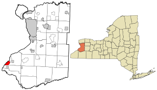
Lake Erie Beach is a hamlet and census-designated place (CDP) in the town of Evans, Erie County, New York, United States. The population was 3,872 at the 2010 census. It is part of the Buffalo–Niagara Falls Metropolitan Statistical Area.

<span class="mw-page-title-main">Fairfield Beach, Ohio</span> Census-designated place in Ohio, United States

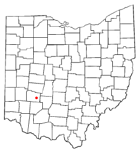
Fairfield Beach is an unincorporated community and census-designated place (CDP) in Fairfield County, Ohio, United States. The population was 1,267 at the 2020 census.

<span class="mw-page-title-main">Shawnee Hills, Greene County, Ohio</span> Census-designated place in Ohio, United States

Shawnee Hills is a census-designated place (CDP) in Greene County, Ohio, United States. Shawnee Hills consists of a planned community centered on the 250-acre (1.0 km2) Shawnee Lake. The population was 2,230 at the 2020 census. It is part of the Dayton Metropolitan Statistical Area, and should not be confused with the incorporated village of Shawnee Hills in Delaware County.

<span class="mw-page-title-main">Lake Shore, Utah</span> CDP in Utah, United States

Lake Shore is a census-designated place (CDP) in Utah County, Utah, United States. It is part of the Provo–Orem Metropolitan Statistical Area. The population was 817 at the 2010 census.

Westlake Corner is a census-designated place in Franklin County, Virginia, United States. The population was 1,553 at the 2020 census up fro 976 at the 2010 census. It is part of the Roanoke Metropolitan Statistical Area.

<span class="mw-page-title-main">Salmon Creek, Washington</span> Census-designated place in Washington, United States

Salmon Creek is a census-designated place (CDP) in Clark County, Washington, United States. The population was 21,293 at the 2020 census.

<span class="mw-page-title-main">Banks Lake South, Washington</span> Census-designated place in Washington, United States

Banks Lake South is a census-designated place (CDP) in Grant County, Washington, United States. The population was 174 at the 2010 census.

<span class="mw-page-title-main">Ames Lake, Washington</span> Census-designated place in Washington, United States

Ames Lake is an unincorporated community and census-designated place (CDP) in King County, Washington, United States. The population was 1,524 at the 2020 census, up from 1,486 at the 2010 census.

<span class="mw-page-title-main">Lake Morton-Berrydale, Washington</span> Census-designated place in Washington, United States

Lake Morton-Berrydale is a census-designated place (CDP) in King County, Washington, United States. The population was 10,474 at the 2020 census.

<span class="mw-page-title-main">Lakeland South, Washington</span> Census-designated place in Washington, United States

Lakeland South is a census-designated place (CDP) in King County, Washington, United States. The population was 13,169 at the 2020 census.

<span class="mw-page-title-main">Maple Heights-Lake Desire, Washington</span> Census-designated place in Washington, United States

Maple Heights-Lake Desire is a census-designated place (CDP) in King County, Washington, United States. At the 2020 census, the population was 3,873.

<span class="mw-page-title-main">Erlands Point-Kitsap Lake, Washington</span> Former CDP in Washington, United States

Erlands Point-Kitsap Lake is an unincorporated area and former census-designated place (CDP) in Kitsap County, Washington, United States. The population was 2,935 at the 2010 census. For the 2020 census, the area was split into two CDPs, Erlands Point and Kitsap Lake.

<span class="mw-page-title-main">Lake Goodwin, Washington</span> Former CDP in Washington, United States

Lake Goodwin is a former census-designated place (CDP) in Snohomish County, Washington, United States. The population was 3,354 at the 2000 census. The CDP was discontinued at the 2010 census.

<span class="mw-page-title-main">Lake Ketchum, Washington</span> CDP in Washington, United States

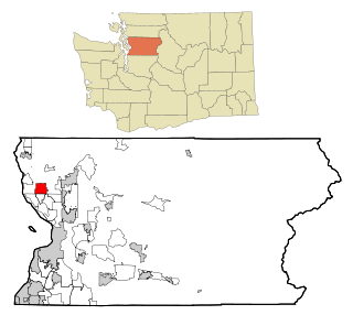
Lake Ketchum is a census-designated place (CDP) in Snohomish County, Washington, United States. The population was 1,268 at the 2020 census, up from 930 at the 2010 census.

<span class="mw-page-title-main">Lake Roesiger, Washington</span> CDP in Washington, United States

Lake Roesiger is a census-designated place (CDP) in Snohomish County, Washington, United States. The population was 611 at the 2020 census, up from 503 at the 2010 census.

<span class="mw-page-title-main">Martha Lake, Washington</span> CDP in Washington, United States

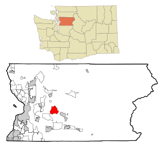
Martha Lake is a census-designated place (CDP) in Snohomish County, Washington, United States. The population was 21,129 at the 2020 census. It lies west of Mill Creek and northeast of Lynnwood, near the lake of the same name.

References

  1. "US Gazetteer files: 2010, 2000, and 1990". United States Census Bureau. February 12, 2011. Retrieved April 23, 2011.
  2. 1 2 "U.S. Census website". United States Census Bureau . Retrieved January 31, 2008.
  3. "US Board on Geographic Names". United States Geological Survey. October 25, 2007. Retrieved January 31, 2008.
  4. 1 2 "Census Bureau profile: Lake Shore, Washington". United States Census Bureau. May 2023. Retrieved May 8, 2024.
  5. 1 2 "Geographic Identifiers: 2010 Demographic Profile Data (G001): Lake Shore CDP, Washington". U.S. Census Bureau, American Factfinder. Retrieved September 1, 2015.[ dead link ]