Cinque Hommes Creek

Last updated
Cinque Hommes Creek
Cinque Hommes Creek, Missouri, Hwy 61 south.jpg
Etymology French meaning "Five Men", or St. Cosme, a Catholic Missionary
Location
Country United States
State Missouri
Physical characteristics
Source 
  location Perry County, MO
  coordinates 37°41′32″N89°53′00″W / 37.69222°N 89.88333°W / 37.69222; -89.88333 [1]
  elevationApproximately 518 ft (158 m) [1]
Mouth Mississippi River
  location
Cape Cinque Hommes, MO
  coordinates
37°45′12″N89°40′12″W / 37.75333°N 89.67000°W / 37.75333; -89.67000 [2]
  elevation
348 ft (106 m) [2]
Length17.1 mi (27.5 km)
Basin size70.1 sq mi (182 km2)

Cinque Hommes Creek is a tributary of the Mississippi River flowing through Perry County, Missouri.

Contents

Name

The early Colonial French name for the creek was "à la viande" or "with meat". [3] Cinque Hommes Creek was named after Cape Cinque Hommes on the Mississippi River, although this name most likely originates from the Canadian Catholic missionary priest Father Jean Francois Buisson de St. Cosme. The pronunciation of "St. Cosme" and "Cinque Hommes" is exactly the same in French, and the early Frenchmen who came after father St. Cosme, misunderstanding, called it by the latter name. [4]

Physical geography

The stream rises in Cinque Hommes Township in Perry County, Missouri, and takes a winding course through Central and Salem townships. Its mouth empties into the Mississippi River near Menfro not far from Cape Cinque Hommes. Five cave systems are found within the Cinque Hommes Creek drainage: Moore Cave, Crevice Cave, Mystery Cave, Rimstone River Cave and Running Bull Cave. [5]

A number of tributaries flow into Cinque Hommes Creek:

  • Ball mill Spring
  • Blue Spring
  • Bois Brule Creek
  • Doc White Spring
  • Hog Pen Spring
  • Keyhole Spring
  • Sandy Branch
  • Schawanes Springs Branch
  • Spring Branch
  • Sutterer Spring
  • Tyler Branch
  • Quarry Spring

Cultural geography

A number of bridges have crossed Cinque Hommes Creek over the years. The Cinque Hommes Creek Route B Bridge was a truss bridge built in 1888, and collapsed on April 15, 1962, following a collusion by an overweight truck. It was replaced in 1963. The Cinque Hommes US 61 Bridge was a truss bridge built in 1930, and replaced in 1996 with a stringer bridge. [6] Cinque Hommes Creek empties into the Mississippi River south of Menfro, Missouri in the Red Rock Landing Conversation Area. [7]

History

Cape St. Cosme or Cape Cinque Hommes - a point on the Mississippi River - was conferred for Father Jean Francois Buisson de Saint Cosme (1667-1702), a missionary priest from the Quebec Seminary of Foreign Missions, who visited the spot in 1698 and erected a cross on Grand Tower. Jean St. Cosme was the son of Michael Buisson, a native of Cosme le Vert in the Diocese of Mans in France, and of Susanne Licheraffe. He was ordained a Seminarian priest at the age of twenty-three. Father St. Cosme was stationed first at Tamaroa, in Illinois, and also labored in Acadia, Louisiana, and among the Natchez Indians in Lower Louisiana. He was massacred by a party of the Chitimacha Indians while descending the Mississippi in 1702. [8] [9]

See also

Related Research Articles

<span class="mw-page-title-main">Perry County, Missouri</span> County in Missouri, United States

Perry County is a county located in the southeastern portion of the U.S. state of Missouri. As of the 2020 census, the population was 18,956. Its county seat is Perryville. The county was officially organized on November 16, 1820 from Ste. Genevieve County and was named after Oliver Hazard Perry, a naval hero of the War of 1812.

<span class="mw-page-title-main">Perryville, Missouri</span> City in Missouri, United States

Perryville is a city in Perry County, Missouri, United States. The population was 8,555 at the 2020 United States census. Perryville is the county seat of Perry County.

<span class="mw-page-title-main">Chester Bridge</span> Bridge in Missouri and Chester, Illinois

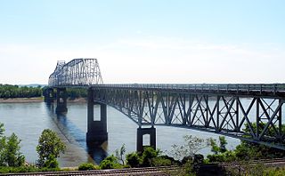
The Chester Bridge is a continuous truss bridge connecting Missouri's Route 51 with Illinois Route 150 across the Mississippi River between Perryville, Missouri and Chester, Illinois. It is the only motor-traffic bridge spanning the Mississippi River between St. Louis and Cape Girardeau, Missouri.

<span class="mw-page-title-main">Menfro, Missouri</span> Unincorporated community in Missouri, United States

Menfro is an unincorporated community in northeastern Perry County, Missouri, United States. It is located 8 miles (13 km) northeast of Perryville.

<span class="mw-page-title-main">Cinque Hommes Township, Perry County, Missouri</span> Township in the US state of Missouri

Cinque Hommes is one of the eight townships located in Perry County, Missouri, in the United States of America.

<span class="mw-page-title-main">Capes on the Mississippi River</span>

The term cape has a different tradition of usage in the American Midwest along the Mississippi River. The middle Mississippi River Valley once formed part of the French Colonies of Quebec and Louisiana, also referred to as Upper Louisiana (Haute-Louisiane) or the Illinois Country. The Illinois Country also included the left bank of the Mississippi River in present-day Missouri.

<span class="mw-page-title-main">Brazeau Township, Perry County, Missouri</span> Township in the US state of Missouri

Brazeau is one of the eight townships located in Perry County, Missouri, in the United States of America.

<span class="mw-page-title-main">Bois Brule Bottom</span> Alluvial floodplain in the American state of Missouri

The Bois Brule Bottom is an alluvial floodplain in Bois Brule Township in Perry County, Missouri stretching between Bois Brule Creek to the west and the Mississippi River to the east.

<span class="mw-page-title-main">Highland, Missouri</span> Unincorporated settlement in the American state of Missouri

Highland is an unincorporated community in Cinque Hommes Township in Perry County, Missouri, United States.

<span class="mw-page-title-main">Millheim, Missouri</span> Unincorporated settlement in the American state of Missouri

Millheim is an unincorporated settlement in Cinque Hommes Township in Perry County, Missouri, United States.

<span class="mw-page-title-main">Silver Lake, Missouri</span> Unincorporated settlement in the American state of Missouri

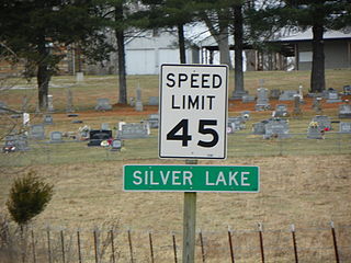
Silver Lake is an unincorporated settlement in Saint Mary's Township in Perry County, Missouri, United States.

<span class="mw-page-title-main">Central Township, Perry County, Missouri</span> Township in the US state of Missouri

Central Township is one of the eight townships located in Perry County, Missouri, United States.

<span class="mw-page-title-main">Salem Township, Perry County, Missouri</span> Township in the US state of Missouri

Salem Township is one of the eight townships located in Perry County, Missouri, in the United States of America.

<span class="mw-page-title-main">Apple Creek (Mississippi River tributary)</span> River in Missouri, United States

Apple Creek is a stream that rises in western Perry County, Missouri and empties into the Mississippi River, forming the boundary between Perry and Cape Girardeau counties.

<span class="mw-page-title-main">Brazeau Creek</span> River in Missouri, United States

Brazeau Creek is a stream flowing through Perry County, Missouri and emptying into the Mississippi River.

<span class="mw-page-title-main">Bois Brule Creek (Cinque Hommes Creek tributary)</span> River in Missouri, United States

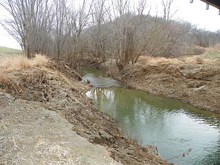
Bois Brule Creek is a tributary of Cinque Hommes Creek in Perry County, Missouri.

<span class="mw-page-title-main">River aux Vases (Mississippi River tributary)</span> River in Missouri, United States

River aux Vases is a creek that rises in Union Township in western Ste. Genevieve County, Missouri and flows into the Mississippi River about two miles north of St. Marys, Missouri.

<span class="mw-page-title-main">Red Rock Landing Conservation Area, Perry County, Missouri</span> Conservation area in Missouri

Red Rock Landing Conservation Area is a conservation area located in eastern Perry County, Missouri at the end of County Road 350, approximately ten miles east of Perryville, Missouri. The Missouri Conservation Department created this area in November 1994 with the purchase of 554-acres along the Mississippi River.

<span class="mw-page-title-main">Peace Lutheran Church (Friedenberg, Missouri)</span> Church in Missouri, United States

Peace Lutheran Church is a former congregation of the Lutheran Church–Missouri Synod (LCMS) in Friedenberg, Missouri.

<span class="mw-page-title-main">Immanuel Lutheran Church (Perryville, Missouri)</span> Church in Missouri , United States

Immanuel Lutheran Church is an LCMS church in Perryville, Missouri.

References

  1. 1 2 Perryville West, MO, 7.5 Minute Topographic Quadrangle, USGS, 1980
  2. 1 2 U.S. Geological Survey Geographic Names Information System: Cinque Hommes Creek
  3. Walter A. Schroeder (2002). Opening the Ozarks: A Historical Geography of Missouri's Ste. Genevieve District, 1760-1830. ISBN   9780826263063.
  4. Robert L. Ramsay (1952). Our Storehouse of Missouri Place Names. ISBN   9780826205865.
  5. State Historical Society of Missouri: Perry County http://shs.umsystem.edu/manuscripts/ramsay/ramsay_perry.html Archived 2016-03-31 at the Wayback Machine
  6. Bridgehunter.com http://bridgehunter.com/mo/perry/
  7. Moatlas http://mdc4.mdc.mo.gov/applications/moatlas/AreaSummaryPage.aspx?txtAreaID=9522 Archived 2014-02-01 at the Wayback Machine
  8. Louis Houck (1908). "A History of Missouri: From the Earliest Explorations and Settlements Until the Admission of the State Into the Union". R. R. Donnelley & Sons Company: 242. cape cinque hommes st. cosme.{{cite journal}}: Cite journal requires |journal= (help)
  9. Sidney Breese; Melville Weston Fuller (1884). "The Early History of Illinois: From Its Discovery by the French, in 1673, Until Its Cession to Great Britain in 1763, Including the Narrative of Marquette's Discovery of the Mississippi". Myers: 143. cape cinque hommes st. cosme.{{cite journal}}: Cite journal requires |journal= (help)