
Interstate 12 (I-12) is an intrastate Interstate Highway located entirely within the US state of Louisiana. It spans a total of 85.59 miles (137.74 km) in an east–west direction from I-10 in Baton Rouge to an interchange with both I-10 and I-59 in Slidell. Along the way, it passes through the city of Hammond, where it intersects I-55 and US Route 51 (US 51). It also serves the cities of Ponchatoula and Denham Springs, as well as the St. Tammany Parish cities of Covington and Mandeville.
West Baton Rouge Parish is one of the sixty-four parishes in the U.S. state of Louisiana. Established in 1807, its parish seat is Port Allen. With a 2020 census population of 27,199 residents, West Baton Rouge Parish is part of the Baton Rouge metropolitan statistical area.

Livingston Parish is a parish in the U.S. state of Louisiana. Its parish seat is the town of Livingston. Livingston Parish is one of the Florida Parishes, a region which, unlike the rest of the state, was part of the Spanish Empire rather than the French Empire.

Zachary is a city in East Baton Rouge Parish, Louisiana, United States. It lies 16 miles (26 km) north of the city of Baton Rouge, and had a population of 14,960 at the 2010 census, up from 11,275 in 2000. At the 2020 census, Zachary's population increased to 19,316.

Albany is a town in eastern Livingston Parish, Louisiana, United States. The population was 1,088 at the 2010 census and 1,235 in 2020. It is part of the Baton Rouge metropolitan statistical area.
Denham Springs is a city in Livingston Parish, Louisiana, United States. The 2010 U.S. census placed the population at 10,215, up from 8,757 at the 2000 U. S. census. At the 2020 United States census, 9,286 people lived in the city. The city is the largest area of commercial and residential development in Livingston Parish. Denham Springs and Walker are the only parish municipalities classified as cities. The area has been known as Amite Springs, Hill's Springs, and Denham Springs.

Springfield is a town in Livingston Parish, Louisiana, United States. The population was 487 at the 2010 census. It is part of the Baton Rouge metropolitan statistical area.

Hammond is the largest city in Tangipahoa Parish, Louisiana, United States, located 45 miles (72 km) east of Baton Rouge and 45 miles (72 km) northwest of New Orleans. Its population was 20,019 in the 2010 U.S. census, and 21,359 at the 2020 population estimates program.

Ponchatoula is the second-largest city in Tangipahoa Parish, Louisiana. The population was 6,559 at the 2010 census and 7,545 at the time of the 2020 population estimates program.

Addis is a town in West Baton Rouge Parish, Louisiana, United States. The population was 3,593 at the 2010 census. It is part of the Baton Rouge Metropolitan Statistical Area.

Port Allen is a city in, and the parish seat of, West Baton Rouge Parish, Louisiana, United States. Located on the west bank of the Mississippi River, it is bordered by Interstate 10 and US Highway 190. The population was 4,939 in 2020. It is part of the Baton Rouge metropolitan statistical area.
Satsuma is an unincorporated community in Livingston Parish, Louisiana, United States. It owes its origin to the US Post Office Department rule which does not permit two post offices in the same state to have the same name. Satsuma is located on U.S. Route 190 between Walker and Livingston, and its original name was Stafford.
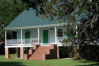
Holden is an unincorporated community located on U.S. Highway 190 between Albany and Livingston in Livingston Parish, Louisiana, United States. Holden is in a section of land awarded to Micajah "Cage" Spiller by a Spanish land grant. LA Hwy 441 which runs through Holden in a northwest–southeast direction is the road that connected Springfield with Baton Rouge to the west and points in Mississippi to the east. In 1907, the east–west line of the Baton Rouge, Hammond & Eastern Railroad was constructed.

Louisiana Highway 42 is a state highway in Louisiana that serves East Baton Rouge, Ascension, Livingston, and Tangipahoa parishes. It spans 47.8 miles (76.9 km) in a general east–west direction.

Louisiana Highway 40 (LA 40) is a state highway located in southeastern Louisiana. It runs 53.11 miles (85.47 km) in an east–west direction from LA 43 south of Montpelier to LA 41 in Bush.
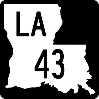
Louisiana Highway 43 (LA 43) is a state highway located in southeastern Louisiana. It runs 44.38 miles (71.42 km) in a north–south direction from LA 42 west of Springfield to the Mississippi state line north of Easleyville, where it continues as Mississippi Highway 568 (MS 568).

Louisiana State Route 7 had multiple suffixed routes, designating bypassed alignments of the highway. They are listed below in order from west to east.

Doyle is an unincorporated community in Livingston Parish, Louisiana, United States. The community is located less than 2 miles east of Livingston and 4 miles west of Holden less than a mile east from the Doyle High School.


