
Van Buren County is a county located in the U.S. state of Iowa. As of the 2020 census the population was 7,203, making it the state's tenth-least populous county. The county seat is Keosauqua, which contains the oldest continuously operational courthouse in the state of Iowa, and second oldest in the United States.

Livingston Parish is a parish in the U.S. state of Louisiana. Its parish seat is the town of Livingston. Livingston Parish is one of the Florida Parishes, a region which, unlike the rest of the state, was part of the Spanish Empire rather than the French Empire.

Albany is a town in eastern Livingston Parish, Louisiana, United States. The population was 1088 at the 2010 census. It is part of the Baton Rouge metropolitan statistical area.

Van Buren is a city in Carter County, Missouri, United States. It is the county seat and largest city in Carter County. Van Buren was founded in 1833 as the county seat of Ripley County and was named after then Vice President of the United States, Martin Van Buren. In 1859, Van Buren became a part of the newly created Carter County and was subsequently selected to be the county seat. The 2020 U.S. Census showed Van Buren with a population of 747.

Broussard is a city in Lafayette and St. Martin parishes in the U.S. state of Louisiana. The population was 8,197 at the 2010 U.S. census, and 13,417 at the 2020 United States census. Broussard is part of the Lafayette metropolitan statistical area.

Solomon Weathersbee Downs was an American attorney, politician, and slaveholder from Louisiana. A Democrat, he served as a United States senator from 1847 to 1853.
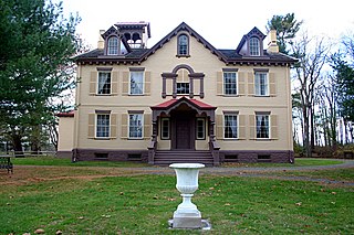
Martin Van Buren National Historic Site is a unit of the United States National Park Service in Columbia County, New York, 1 mile (1.6 km) south of the village of Kinderhook, 125 miles (201 km) north of New York City and 20 miles (32 km) south of Albany. The National Historic Site preserves the Lindenwald estate owned by Martin Van Buren, the eighth president of the United States. Van Buren purchased the 36-room mansion during his presidency in 1839, and it became his home and farm from his leaving office in 1841 until his death in 1862.
Corbin is an unincorporated community in Livingston Parish, Louisiana, United States. The community is located 6 miles east of Denham Springs and 6 miles west of Livingston.
Denson also known as Bear Island is an unincorporated community in Livingston Parish, Louisiana, United States. The community is located 2 miles southeast of Maurepas and 6 miles southwest of Killian north of the Blind River.

Doyle is an unincorporated community in Livingston Parish, Louisiana, United States. The community is located less than 2 miles east of Livingston and 4 miles west of Holden less than a mile east from the Doyle High School.
Georgeville is an unincorporated community in Livingston Parish, Louisiana, United States. The community is located 8 miles southwest of Livingston and 2 miles southeast of Montpelier on Louisiana Highway 43.
Horse Bluff Landing is an unincorporated community in Livingston Parish, Louisiana, United States. The community is located less than 3 miles west of Killian and 5 miles northeast of Maurepas on the bank of Tickfaw River. The Tickfaw State Park is located 1 mile to the northwest across the Tickfaw River.
Oldfield is an unincorporated community in Livingston Parish, Louisiana, United States. The community is located 9 miles north of Walker and 4 miles southeast of Baywood.
Poley, also known as Poley Bayou, is an unincorporated community in Livingston Parish, Louisiana, United States. The community is located 2 miles northwest of French Settlement and 2 miles east of Port Vincent.
Starns also known as Starns Mill is an unincorporated community in Livingston Parish, Louisiana, United States. The community is located 6 miles northwest of Albany and 4 miles north of Holden.
Magnolia, also known as Otts Mill, is an unincorporated community in Livingston Parish, Louisiana, United States. The community is located 5 miles northwest of Livingston and 2 miles west of Starns on Louisiana Highway 442 at the intersection with Louisiana Highway 1036.
Verdun is an unincorporated community in Livingston Parish, Louisiana, United States. The community is located less than 4 miles east of French Settlement and 5 miles northwest of Maurepas. Also, Verdun is the true hometown of the 2019 American Idol Winner Laine Hardy.
Weiss is an unincorporated community in Livingston Parish, Louisiana, United States. The community is located less than 3 miles southwest of Baywood and 6 miles northeast of Watson near the Amite River.


