
Louisiana is a state in the Deep South and South Central regions of the United States. It is bordered by the state of Texas to the west, Arkansas to the north, Mississippi to the east, and the Gulf of Mexico to the south; a large part of its eastern boundary is demarcated by the Mississippi River. Of the 50 U.S. states, it ranks 20th in land area and the 25th in population, with roughly 4.6 million residents. Reflecting its French heritage, Louisiana is the only U.S. state with political subdivisions termed parishes, which are equivalent to counties, making it one of only two U.S. states not subdivided into counties. The state's capital is Baton Rouge, and its largest city is New Orleans, with a population of roughly 383,000 people.

Vermilion Parish is a parish located in the U.S. state of Louisiana, created in 1844. The parish seat is Abbeville. Vermilion Parish is part of the Lafayette metropolitan statistical area, and located in southern Acadiana. At the 2020 U.S. census, the population was 57,359.
Plaquemines Parish is a parish located in the U.S. state of Louisiana. With a population of 23,515 at the 2020 census, the parish seat is Pointe à la Hache and the largest community is Belle Chasse. The parish was formed in 1807.

Livingston Parish is a parish in the U.S. state of Louisiana. Its parish seat is the town of Livingston. Livingston Parish is one of the Florida Parishes, a region which, unlike the rest of the state, was part of the Spanish Empire rather than the French Empire.

Cameron Parish is a parish in the southwest corner of the U.S. state of Louisiana. As of the 2020 census, the population was 5,617. The parish seat is Cameron. Although it is the largest parish by area in Louisiana, it has the second-smallest population in the state, ahead of only Tensas. Cameron Parish is part of the Lake Charles metropolitan statistical area.

Grand Isle is a town in Jefferson Parish in the U.S. state of Louisiana, located on a barrier island of the same name in the Gulf of Mexico. The island is at the mouth of Barataria Bay where it meets the gulf. The town of Grand Isle is statistically part of the New Orleans−Metairie−Kenner metropolitan statistical area, though it is not connected to New Orleans' continuous urbanized area.

Sabine Lake is a bay on the Gulf coasts of Texas and Louisiana, located approximately 90 miles (140 km) east of Houston and 160 miles (260 km) west of Baton Rouge, adjoining the city of Port Arthur. The lake is formed by the confluence of the Neches and Sabine Rivers and connects to the Gulf of Mexico through Sabine Pass. It forms part of the Texas–Louisiana border, falling within Jefferson and Orange Counties in Texas and Cameron Parish, Louisiana.

Sabine Pass is the natural outlet of Sabine Lake into the Gulf of Mexico. It borders Jefferson County, Texas, and Cameron Parish, Louisiana.
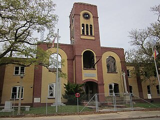
Pointe à la Hache is a census-designated place (CDP) and unincorporated community in Plaquemines Parish, Louisiana, United States. Located on the east bank of the Mississippi River, the village has been the seat for Plaquemines Parish since the formation of the parish. As of the 2020 census, its population was 183, less than half its 1930 population. It suffered severe damage from Hurricane Katrina in 2005 and Tropical Storm Lee in 2011.

The Mississippi River Delta is the confluence of the Mississippi River with the Gulf of Mexico in Louisiana, southeastern United States. The river delta is a three-million-acre area of land that stretches from Vermilion Bay on the west, to the Chandeleur Islands in the east, on Louisiana's southeastern coast. It is part of the Gulf of Mexico and the Louisiana coastal plain, one of the largest areas of coastal wetlands in the United States. The Mississippi River Delta is the 7th largest river delta on Earth (USGS) and is an important coastal region for the United States, containing more than 2.7 million acres of coastal wetlands and 37% of the estuarine marsh in the conterminous U.S. The coastal area is the nation's largest drainage basin and drains about 41% of the contiguous United States into the Gulf of Mexico at an average rate of 470,000 cubic feet per second.

Hurricane Katrina was a devastating Category 5 Atlantic hurricane that resulted in 1,392 fatalities and caused damage estimated between $97.4 billion to $145.5 billion in late August 2005, particularly in the city of New Orleans and its surrounding areas. At the time, it was the costliest tropical cyclone on record, tied now with Hurricane Harvey of 2017. Katrina was the twelfth tropical cyclone, the fifth hurricane, and the third major hurricane of the 2005 Atlantic hurricane season. It was also the fourth-most intense Atlantic hurricane on record that made landfall in the contiguous United States.

Louisiana Highway 82 (LA 82) is a state highway located in southern Louisiana. It runs 142.87 miles (229.93 km) in a general east–west direction from the Texas state line east of Port Arthur to the Vermilion–Lafayette parish line southwest of Youngsville.

Barataria Bay, also Barrataria Bay, is a bay of the Gulf of Mexico, about 15 miles (24 km) long and 12 miles (19 km) wide, in southeastern Louisiana, in Jefferson Parish and Plaquemines Parish, United States. It is separated from the gulf by two barrier islands, Grand Isle and Grand Terre.
The Morganza to the Gulf Hurricane Protection Project is a flood protection system for Terrebonne Parish and Lafourche Parish in the U.S. state of Louisiana. The targeted area is bounded on the west by Bayou Du Large and LA 311 and on the east by Bayou Lafourche. The U.S. Army Corps of Engineers is the federal sponsor for this project, and the Louisiana Department of Transportation and Development with the Terrebonne Levee and Conservation District jointly serve as the local sponsor. The Terrebonne Levee and Conservation District will provide operations and maintenance once the system is complete.
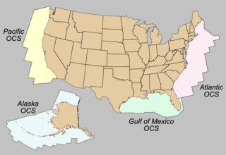
The Outer Continental Shelf (OCS) is a feature of the geography of the United States. The OCS is the part of the internationally recognized continental shelf of the United States which does not fall under the jurisdictions of the individual U.S. states.

Offshore oil and gas in the Gulf of Mexico is a major source of oil and natural gas in the United States. The western and central Gulf of Mexico, which includes offshore Texas, Louisiana, Mississippi, and Alabama, is one of the major petroleum-producing areas of the United States. Oil production from US federal waters in the Gulf of Mexico reached an all-time annual high of 1.65 million barrels per day in 2017. Oil production is expected to continue the upward trend in 2018 and 2019, based on ten new oil fields which are planned to start production in those years. According to the Energy Information Administration, "Gulf of Mexico federal offshore oil production accounts for 15% of total U.S. crude oil production and federal offshore natural gas production in the Gulf accounts for 5% of total U.S. dry production."
Coteau Bourgeois is an unincorporated community in Livingston Parish, Louisiana, United States. The community is located 5 miles southeast of French Settlement and 8 miles west of Sorrento. The site is on Louisiana Highway 22 and is one mile south of Head of Island on the Amite River.
Denson also known as Bear Island is an unincorporated community in Livingston Parish, Louisiana, United States. The community is located 2 miles southeast of Maurepas and 6 miles southwest of Killian north of the Blind River.
Horse Bluff Landing is an unincorporated community in Livingston Parish, Louisiana, United States. The community is located less than 3 miles west of Killian and 5 miles northeast of Maurepas on the bank of Tickfaw River. The Tickfaw State Park is located 1 mile to the northwest across the Tickfaw River.


