In cartography, the normal cylindrical equal-area projection is a family of normal cylindrical, equal-area map projections.
In cartography, the normal cylindrical equal-area projection is a family of normal cylindrical, equal-area map projections.
The invention of the Lambert cylindrical equal-area projection is attributed to the Swiss mathematician Johann Heinrich Lambert in 1772. [1] Variations of it appeared over the years by inventors who stretched the height of the Lambert and compressed the width commensurately in various ratios.
The projection:
The term "normal cylindrical projection" is used to refer to any projection in which meridians are mapped to equally spaced vertical lines and circles of latitude are mapped to horizontal lines (or, mutatis mutandis , more generally, radial lines from a fixed point are mapped to equally spaced parallel lines and concentric circles around it are mapped to perpendicular lines).
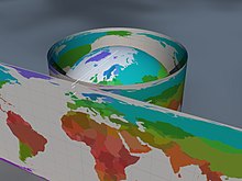
The mapping of meridians to vertical lines can be visualized by imagining a cylinder whose axis coincides with the Earth's axis of rotation, then projecting onto the cylinder, and subsequently unfolding the cylinder.
By the geometry of their construction, cylindrical projections stretch distances east-west. The amount of stretch is the same at any chosen latitude on all cylindrical projections, and is given by the secant of the latitude as a multiple of the equator's scale. The various cylindrical projections are distinguished from each other solely by their north-south stretching (where latitude is given by φ):
The only normal cylindrical projections that preserve area have a north-south compression precisely the reciprocal of east-west stretching (cos φ). This divides north-south distances by a factor equal to the secant of the latitude, preserving area but distorting shapes.
Depending on the stretch factor S, any particular cylindrical equal-area projection either has zero, one or two latitudes for which the east–west scale matches the north–south scale.
The formulae presume a spherical model and use these definitions: [3]
| using standard latitude φ0 | using stretch factor S | S=1, φ0=0 | |
|---|---|---|---|
| using radians | |||
| using degrees |
Relationship between and :
The specializations differ only in the ratio of the vertical to horizontal axis. Some specializations have been described, promoted, or otherwise named. [4] [5] [6] [7] [8]
| Stretch factor S | Aspect ratio (width-to-height) πS | Standard parallel(s) φ0 | Image (Tissot's indicatrix) | Image (Blue Marble) | Name | Publisher | Year of publication |
|---|---|---|---|---|---|---|---|
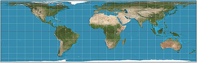
| 1 | π ≈ 3.142 | 0° |  | 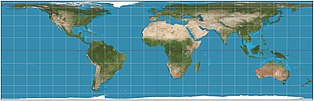 | Lambert cylindrical equal-area | Johann Heinrich Lambert | 1772 |
| 3/4 = 0.75 | 3π/4 ≈ 2.356 | 30° |  | 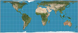 | Behrmann | Walter Behrmann | 1910 |
| 2/π ≈ 0.6366 | 2 | ≈ 37°04′17″ ≈ 37.0714° |  | 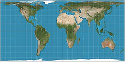 | Smyth equal-surface = Craster rectangular | Charles Piazzi Smyth | 1870 |
| cos2(37.4°) ≈ 0.6311 | π·cos2(37.4°) ≈ 1.983 | 37°24′ = 37.4° |  | 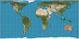 | Trystan Edwards | Trystan Edwards | 1953 |
| cos2(37.5°) ≈ 0.6294 | π·cos2(37.5°) ≈ 1.977 | 37°30′ = 37.5° | 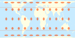 | 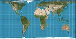 | Hobo–Dyer | Mick Dyer | 2002 |
| cos2(40°) ≈ 0.5868 | π·cos2(40°) ≈ 1.844 | 40° |  |  | (unnamed) | ||
| 1/2 =0.5 | π/2 ≈ 1.571 | 45° |  |  | Gall–Peters = Gall orthographic = Peters | James Gall, Promoted by Arno Peters as his own invention | 1855 (Gall), 1967 (Peters) |
| cos2(50°) ≈ 0.4132 | π·cos2(50°) ≈ 1.298 | 50° |  |  | Balthasart | M. Balthasart | 1935 |
| 1/π ≈ 0.3183 | 1 | ≈ 55°39′14″ ≈ 55.6540° | 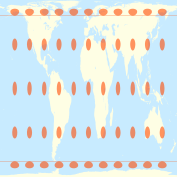 |  | Tobler's world in a square | Waldo Tobler | 1986 |
The Tobler hyperelliptical projection, first described by Tobler in 1973, is a further generalization of the cylindrical equal-area family.
The HEALPix projection is an equal-area hybrid combination of: the Lambert cylindrical equal-area projection, for the equatorial regions of the sphere; and an interrupted Collignon projection, for the polar regions.

The Gall–Peters projection is a rectangular, equal-area map projection. Like all equal-area projections, it distorts most shapes. It is a cylindrical equal-area projection with latitudes 45° north and south as the regions on the map that have no distortion. The projection is named after James Gall and Arno Peters.

In geography, latitude is a coordinate that specifies the north–south position of a point on the surface of the Earth or another celestial body. Latitude is given as an angle that ranges from −90° at the south pole to 90° at the north pole, with 0° at the Equator. Lines of constant latitude, or parallels, run east–west as circles parallel to the equator. Latitude and longitude are used together as a coordinate pair to specify a location on the surface of the Earth.

The Mercator projection is a conformal cylindrical map projection presented by Flemish geographer and cartographer Gerardus Mercator in 1569. It became the standard map projection for navigation due to its ability to represent north as 'up' and south as 'down' everywhere while preserving local directions and shapes. However, as a result, the Mercator projection inflates the size of objects the further they are from the equator. In a Mercator projection, landmasses such as Greenland and Antarctica appear far larger than they actually are relative to landmasses near the equator. Despite these drawbacks, the Mercator projection is well-suited to marine navigation and internet web maps and continues to be widely used today.

In cartography, a map projection is any of a broad set of transformations employed to represent the curved two-dimensional surface of a globe on a plane. In a map projection, coordinates, often expressed as latitude and longitude, of locations from the surface of the globe are transformed to coordinates on a plane. Projection is a necessary step in creating a two-dimensional map and is one of the essential elements of cartography.

A circle of latitude or line of latitude on Earth is an abstract east–west small circle connecting all locations around Earth at a given latitude coordinate line.

In navigation, a rhumb line, rhumb, or loxodrome is an arc crossing all meridians of longitude at the same angle, that is, a path with constant bearing as measured relative to true north.

The transverse Mercator map projection is an adaptation of the standard Mercator projection. The transverse version is widely used in national and international mapping systems around the world, including the Universal Transverse Mercator. When paired with a suitable geodetic datum, the transverse Mercator delivers high accuracy in zones less than a few degrees in east-west extent.

Orthographic projection in cartography has been used since antiquity. Like the stereographic projection and gnomonic projection, orthographic projection is a perspective projection in which the sphere is projected onto a tangent plane or secant plane. The point of perspective for the orthographic projection is at infinite distance. It depicts a hemisphere of the globe as it appears from outer space, where the horizon is a great circle. The shapes and areas are distorted, particularly near the edges.

The scale of a map is the ratio of a distance on the map to the corresponding distance on the ground. This simple concept is complicated by the curvature of the Earth's surface, which forces scale to vary across a map. Because of this variation, the concept of scale becomes meaningful in two distinct ways.

The equirectangular projection, and which includes the special case of the plate carrée projection, is a simple map projection attributed to Marinus of Tyre, who Ptolemy claims invented the projection about AD 100.

The sinusoidal projection is a pseudocylindrical equal-area map projection, sometimes called the Sanson–Flamsteed or the Mercator equal-area projection. Jean Cossin of Dieppe was one of the first mapmakers to use the sinusoidal, using it in a world map in 1570.

The Universal Transverse Mercator (UTM) is a map projection system for assigning coordinates to locations on the surface of the Earth. Like the traditional method of latitude and longitude, it is a horizontal position representation, which means it ignores altitude and treats the earth surface as a perfect ellipsoid. However, it differs from global latitude/longitude in that it divides earth into 60 zones and projects each to the plane as a basis for its coordinates. Specifying a location means specifying the zone and the x, y coordinate in that plane. The projection from spheroid to a UTM zone is some parameterization of the transverse Mercator projection. The parameters vary by nation or region or mapping system.

The Aitoff projection is a modified azimuthal map projection proposed by David A. Aitoff in 1889. Based on the equatorial form of the azimuthal equidistant projection, Aitoff first halves longitudes, then projects according to the azimuthal equidistant, and then stretches the result horizontally into a 2:1 ellipse to compensate for having halved the longitudes.

The Hammer projection is an equal-area map projection described by Ernst Hammer in 1892. Using the same 2:1 elliptical outer shape as the Mollweide projection, Hammer intended to reduce distortion in the regions of the outer meridians, where it is extreme in the Mollweide.

The Cassini projection is a map projection first described in an approximate form by César-François Cassini de Thury in 1745. Its precise formulas were found through later analysis by Johann Georg von Soldner around 1810. It is the transverse aspect of the equirectangular projection, in that the globe is first rotated so the central meridian becomes the "equator", and then the normal equirectangular projection is applied. Considering the earth as a sphere, the projection is composed of the operations:

The Tobler hyperelliptical projection is a family of equal-area pseudocylindrical projections that may be used for world maps. Waldo R. Tobler introduced the construction in 1973 as the hyperelliptical projection, now usually known as the Tobler hyperelliptical projection.

The Eckert II projection is an equal-area pseudocylindrical map projection. In the equatorial aspect the network of longitude and latitude lines consists solely of straight lines, and the outer boundary has the distinctive shape of an elongated hexagon. It was first described by Max Eckert in 1906 as one of a series of three pairs of pseudocylindrical projections. Within each pair, the meridians have the same shape, and the odd-numbered projection has equally spaced parallels, whereas the even-numbered projection has parallels spaced to preserve area. The pair to Eckert II is the Eckert I projection.

The central cylindrical projection is a perspective cylindrical map projection. It corresponds to projecting the Earth's surface onto a cylinder tangent to the equator as if from a light source at Earth's center. The cylinder is then cut along one of the projected meridians and unrolled into a flat map.

The Gall stereographic projection, presented by James Gall in 1855, is a cylindrical projection. It is neither equal-area nor conformal but instead tries to balance the distortion inherent in any projection.

The rectangular polyconic projection is a map projection was first mentioned in 1853 by the United States Coast Survey, where it was developed and used for portions of the U.S. exceeding about one square degree. It belongs to the polyconic projection class, which consists of map projections whose parallels are non-concentric circular arcs except for the equator, which is straight. Sometimes the rectangular polyconic is called the War Office projection due to its use by the British War Office for topographic maps. It is not used much these days, with practically all military grid systems having moved onto conformal projection systems, typically modeled on the transverse Mercator projection.


