
The cosmic microwave background is microwave radiation that fills all space in the observable universe. It is a remnant that provides an important source of data on the primordial universe. With a standard optical telescope, the background space between stars and galaxies is almost completely dark. However, a sufficiently sensitive radio telescope detects a faint background glow that is almost uniform and is not associated with any star, galaxy, or other object. This glow is strongest in the microwave region of the radio spectrum. The accidental discovery of the CMB in 1965 by American radio astronomers Arno Penzias and Robert Wilson was the culmination of work initiated in the 1940s.

In geography, latitude is a coordinate that specifies the north–south position of a point on the surface of the Earth or another celestial body. Latitude is given as an angle that ranges from –90° at the south pole to 90° at the north pole, with 0° at the Equator. Lines of constant latitude, or parallels, run east–west as circles parallel to the equator. Latitude and longitude are used together as a coordinate pair to specify a location on the surface of the Earth.

In cartography, a map projection is any of a broad set of transformations employed to represent the curved two-dimensional surface of a globe on a plane. In a map projection, coordinates, often expressed as latitude and longitude, of locations from the surface of the globe are transformed to coordinates on a plane. Projection is a necessary step in creating a two-dimensional map and is one of the essential elements of cartography.
In physical cosmology, the shape of the universe refers to both its local and global geometry. Local geometry is defined primarily by its curvature, while the global geometry is characterised by its topology. General relativity explains how spatial curvature is constrained by gravity. The global topology of the universe cannot be deduced from measurements of curvature inferred from observations within the family of homogeneous general relativistic models alone, due to the existence of locally indistinguishable spaces with varying global topological characteristics. For example; a multiply connected space like a 3 torus has everywhere zero curvature but is finite in extent, whereas a flat simply connected space is infinite in extent.
In modern physical cosmology, the cosmological principle is the notion that the spatial distribution of matter in the universe is equally distributed and isotropic when viewed on a large enough scale, since the forces are expected to act equally throughout the universes on a large scale, and should, therefore, produce no observable inequalities in the large-scale structuring over the course of evolution of the matter field that was initially laid down by the Big Bang.
Flexible Image Transport System (FITS) is an open standard defining a digital file format useful for storage, transmission and processing of data: formatted as multi-dimensional arrays, or tables. FITS is the most commonly used digital file format in astronomy. The FITS standard was designed specifically for astronomical data, and includes provisions such as describing photometric and spatial calibration information, together with image origin metadata.
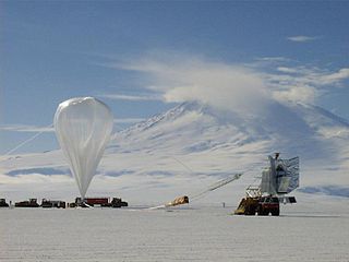
In astronomy and observational cosmology, the BOOMERanG experiment was an experiment which measured the cosmic microwave background radiation of a part of the sky during three sub-orbital (high-altitude) balloon flights. It was the first experiment to make large, high-fidelity images of the CMB temperature anisotropies, and is best known for the discovery in 2000 that the geometry of the universe is close to flat, with similar results from the competing MAXIMA experiment.

According to modern models of physical cosmology, a dark matter halo is a basic unit of cosmological structure. It is a hypothetical region that has decoupled from cosmic expansion and contains gravitationally bound matter. A single dark matter halo may contain multiple virialized clumps of dark matter bound together by gravity, known as subhalos. Modern cosmological models, such as ΛCDM, propose that dark matter halos and subhalos may contain galaxies. The dark matter halo of a galaxy envelops the galactic disc and extends well beyond the edge of the visible galaxy. Thought to consist of dark matter, halos have not been observed directly. Their existence is inferred through observations of their effects on the motions of stars and gas in galaxies and gravitational lensing. Dark matter halos play a key role in current models of galaxy formation and evolution. Theories that attempt to explain the nature of dark matter halos with varying degrees of success include cold dark matter (CDM), warm dark matter, and massive compact halo objects (MACHOs).
In computer graphics, environment mapping, or reflection mapping, is an efficient image-based lighting technique for approximating the appearance of a reflective surface by means of a precomputed texture. The texture is used to store the image of the distant environment surrounding the rendered object.

The South Pole Telescope (SPT) is a 10-metre (390 in) diameter telescope located at the Amundsen–Scott South Pole Station, Antarctica. The telescope is designed for observations in the microwave, millimeter-wave, and submillimeter-wave regions of the electromagnetic spectrum, with the particular design goal of measuring the faint, diffuse emission from the cosmic microwave background (CMB). The first major survey with the SPT—designed to find distant, massive, clusters of galaxies through their interaction with the CMB, with the goal of constraining the dark energy equation of state—was completed in October 2011. In early 2012, a new camera (SPTpol) was installed on the SPT with even greater sensitivity and the capability to measure the polarization of incoming light. This camera operated from 2012–2016 and was used to make unprecedentedly deep high-resolution maps of hundreds of square degrees of the Southern sky. In 2017, the third-generation camera SPT-3G was installed on the telescope, providing nearly an order-of-magnitude increase in mapping speed over SPTpol.

A geodesic grid is a spatial grid based on a geodesic polyhedron or Goldberg polyhedron.

In cosmology, a Hubble volume (named for the astronomer Edwin Hubble) or Hubble sphere, Hubble bubble, subluminal sphere, causal sphere and sphere of causality is a spherical region of the observable universe surrounding an observer beyond which objects recede from that observer at a rate greater than the speed of light due to the expansion of the universe. The Hubble volume is approximately equal to 1031 cubic light years (or about 1079 cubic meters).

Galaxy mergers can occur when two galaxies collide. They are the most violent type of galaxy interaction. The gravitational interactions between galaxies and the friction between the gas and dust have major effects on the galaxies involved. The exact effects of such mergers depend on a wide variety of parameters such as collision angles, speeds, and relative size/composition, and are currently an extremely active area of research. Galaxy mergers are important because the merger rate is a fundamental measurement of galaxy evolution. The merger rate also provides astronomers with clues about how galaxies bulked up over time.
An inhomogeneous cosmology is a physical cosmological theory which, unlike the currently widely accepted cosmological concordance model, assumes that inhomogeneities in the distribution of matter across the universe affect local gravitational forces enough to skew our view of the Universe. When the universe began, matter was distributed homogeneously, but over billions of years, galaxies, clusters of galaxies, and superclusters have coalesced, and must, according to Einstein's theory of general relativity, warp the space-time around them. While the concordance model acknowledges this fact, it assumes that such inhomogeneities are not sufficient to affect large-scale averages of gravity in our observations. When two separate studies claimed in 1998-1999 that high redshift supernovae were further away than our calculations showed they should be, it was suggested that the expansion of the universe is accelerating, and dark energy, a repulsive energy inherent in space, was proposed to explain the acceleration. Dark energy has since become widely accepted, but it remains unexplained. Accordingly, some scientists continue to work on models that might not require dark energy. Inhomogeneous cosmology falls into this class.
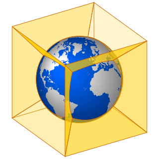
In mapmaking, a quadrilateralized spherical cube, or quad sphere for short, is an equal-area polyhedral map projection and discrete global grid scheme for data collected on a spherical surface. It was first proposed in 1975 by Chan and O'Neill for the Naval Environmental Prediction Research Facility. This scheme is also often called the COBE sky cube, because it was designed to hold data from the Cosmic Background Explorer (COBE) project.

Astropy is a collection of software packages written in the Python programming language and designed for use in astronomy. The software is a single, free, core package for astronomical utilities due to the increasingly widespread usage of Python by astronomers, and to foster interoperability between various extant Python astronomy packages. Astropy is included in several large Python distributions; it is part of package managers for Linux and macOS, the Anaconda Python Distribution, Enthought Canopy and Ureka.

Cosmic voids are vast spaces between filaments, which contain very few or no galaxies. Most galaxies are not located in voids, despite their size, due to most galaxies being gravitationally bound together, creating huge cosmic structures known as galaxy filaments. The cosmological evolution of the void regions differs drastically from the evolution of the Universe as a whole: there is a long stage when the curvature term dominates, which prevents the formation of galaxy clusters and massive galaxies. Hence, although even the emptiest regions of voids contain more than ~15% of the average matter density of the Universe, the voids look almost empty to an observer.

A discrete global grid (DGG) is a mosaic that covers the entire Earth's surface. Mathematically it is a space partitioning: it consists of a set of non-empty regions that form a partition of the Earth's surface. In a usual grid-modeling strategy, to simplify position calculations, each region is represented by a point, abstracting the grid as a set of region-points. Each region or region-point in the grid is called a cell.
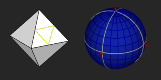
Hierarchical Triangular Mesh (HTM) is a kind of quad tree based on subdivision of a distorted octahedron, used for mesh generation in 3-D computer graphics and geometric data structures.

