The United States Virgin Islands, officially the Virgin Islands of the United States, are a group of Caribbean islands and an unincorporated and organized territory of the United States. The islands are geographically part of the Virgin Islands archipelago and are located in the Leeward Islands of the Lesser Antilles to the east of Puerto Rico and west of the British Virgin Islands.

Okeechobee County is a county located in the Florida Heartland region of the state of Florida. As of the 2020 census, the population was 39,644. The county seat is Okeechobee.

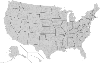
In the United States, a county is an administrative or political subdivision of a state that consists of a geographic region with specific boundaries and usually some level of governmental authority. The term "county" is used in 48 states, while Louisiana and Alaska have functionally equivalent subdivisions called parishes and boroughs, respectively. The specific governmental powers of counties vary widely between the states, with many providing some level of services to civil townships, municipalities, and unincorporated areas. Certain municipalities are in multiple counties; New York City is uniquely partitioned into five counties, referred to at the city government level as boroughs. Some municipalities have consolidated with their county government to form consolidated city-counties, or have been legally separated from counties altogether to form independent cities. Conversely, those counties in Connecticut, Rhode Island, eight of Massachusetts's 14 counties, and Alaska's Unorganized Borough have no government power, existing only as geographic distinctions.

Saint Croix is an island in the Caribbean Sea, and a county and constituent district of the United States Virgin Islands (USVI), an unincorporated territory of the United States.
In 45 of the 50 states of the United States, the county is used for the level of local government immediately below the state itself. Louisiana uses parishes, and Alaska uses boroughs. In Connecticut, Massachusetts, and Rhode Island, some or all counties within states have no governments of their own; the counties continue to exist as legal entities, however, and are used by states for some administrative functions and by the United States Census bureau for statistical analysis. There are 3,242 counties and county equivalent administrative units in total, including the District of Columbia and 100 county-equivalents in the U.S. territories.

Saint Thomas is one of the Virgin Islands in the Caribbean Sea which, together with Saint John, Water Island, Hassel Island, and Saint Croix, form a county-equivalent and constituent district of the United States Virgin Islands (USVI), an unincorporated territory of the United States. The territorial capital and port of Charlotte Amalie is located on the island. In the 2010 census, the population of Saint Thomas was 51,634, about 48.5% of the US Virgin Islands total. As of the 2020 census, the population of Saint Thomas is 42,461. The district has a land area of 32 square miles (83 km2).

Territories of the United States are sub-national administrative divisions overseen by the Federal government of the United States. The various American territories differ from the U.S. states and Native American tribes in that they are not sovereign entities. In contrast, each state has a sovereignty separate from that of the federal government and each federally recognized Native American tribe possesses limited tribal sovereignty as a "dependent sovereign nation". Territories are classified by incorporation and whether they have an "organized" government through an organic act passed by the Congress. American territories are under American sovereignty and, consequently, may be treated as part of the United States proper in some ways and not others. Unincorporated territories in particular are not considered to be integral parts of the United States, and the Constitution of the United States applies only partially in those territories.

Saint John is one of the Virgin Islands in the Caribbean Sea and a constituent district of the United States Virgin Islands (USVI), an unincorporated territory of the United States.

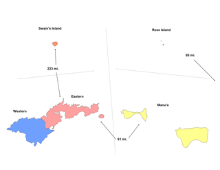
The Manuʻa District is one of the three primary administrative divisions of American Samoa. The district comprises the Manuʻa Islands, which are located approximately 61 miles east of the main island, Tutuila. The Manuʻa District is considered to be a county-equivalent by the U.S. Census Bureau.
West End is the name of one of the seven census subdistricts (CSD) on the island of Saint Thomas in the United States Virgin Islands. Some of the populated communities here include Adelphi, John Oley, Sorgenfri, Fortuna, and Bonne Esperance. According to the U.S. Bureau of the Census in 2010, the total population is 2,241, which is an increase of 8.9% from the 2000 U.S. Census, when 2,056 lived in the West End subdistrict. According to the Census of 2010, there are 1,128 housing units in the subdistrict, which is only less than Water Island subdistrict with its 203 housing units.

Albert Bryan Jr. is an American Virgin Islander politician who is the ninth elected governor of the United States Virgin Islands, since 2019.


