Fredericksburg, Iowa | |
---|---|
![]() Downtown Fredericksburg | |
Nickname: Dairy Capital of Iowa | |
Motto(s): "A Place to Visit, to Live and to Call Home" [1] | |
![]() Location of Fredericksburg, Iowa | |
Coordinates: 42°57′53″N92°11′54″W / 42.96472°N 92.19833°W | |
Country | ![]() |
State | ![]() |
County | Chickasaw |
Government | |
• Mayor | David Faye |
Area | |
• Total | 0.90 sq mi (2.33 km2) |
• Land | 0.90 sq mi (2.33 km2) |
• Water | 0.00 sq mi (0.00 km2) |
Elevation | 1,076 ft (328 m) |
Population (2020) | |
• Total | 987 |
• Density | 1,096.67/sq mi (423.59/km2) |
Time zone | UTC-6 (Central (CST)) |
• Summer (DST) | UTC-5 (CDT) |
ZIP code | 50630 |
Area code | 563 |
FIPS code | 19-28965 |
GNIS feature ID | 0456750 |
Website | Fredericksburg, Iowa Website |
Fredericksburg is a city in Chickasaw County, Iowa, United States. The population was 987 at the time of the 2020 census. [3]
Fredericksburg was incorporated on December 18, 1894. [4] The city was named after Frederick Padden, a local settler who platted the village in 1856. [5] [6] In the late 1800s, Dr. William S. Pitts, a local physician and composer who wrote The Church in the Wildwood, served as mayor of the town.
Bert L. Van Gorden (1873-1941), Wisconsin State Assemblyman and businessman, was born in Fredericksburg. [7]
Fredericksburg is located at 42°57′53″N92°11′54″W / 42.96472°N 92.19833°W (42.964586, -92.198465). [8]
According to the United States Census Bureau, the city has a total area of 0.86 square miles (2.23 km2), all land. [9]
Year | Pop. | ±% |
---|---|---|
1880 | 203 | — |
1890 | 321 | +58.1% |
1900 | 565 | +76.0% |
1910 | 558 | −1.2% |
1920 | 624 | +11.8% |
1930 | 567 | −9.1% |
1940 | 649 | +14.5% |
1950 | 701 | +8.0% |
1960 | 797 | +13.7% |
1970 | 912 | +14.4% |
1980 | 1,075 | +17.9% |
1990 | 1,011 | −6.0% |
2000 | 984 | −2.7% |
2010 | 931 | −5.4% |
2020 | 987 | +6.0% |
Source: "U.S. Census website". United States Census Bureau . Retrieved March 28, 2020. and Iowa Data Center Source: |
As of the census [11] of 2010, there were 931 people, 427 households, and 260 families living in the city. The population density was 1,082.6 inhabitants per square mile (418.0/km2). There were 462 housing units at an average density of 537.2 per square mile (207.4/km2). The racial makeup of the city was 96.1% White, 0.2% African American, 0.2% Native American, 0.1% Asian, 2.3% from other races, and 1.1% from two or more races. Hispanic or Latino of any race were 3.4% of the population.
There were 427 households, of which 23.4% had children under the age of 18 living with them, 50.6% were married couples living together, 6.3% had a female householder with no husband present, 4.0% had a male householder with no wife present, and 39.1% were non-families. 34.7% of all households were made up of individuals, and 17.1% had someone living alone who was 65 years of age or older. The average household size was 2.18 and the average family size was 2.77.
The median age in the city was 44.5 years. 21.6% of residents were under the age of 18; 6.7% were between the ages of 18 and 24; 22.5% were from 25 to 44; 27% were from 45 to 64; and 22.3% were 65 years of age or older. The gender makeup of the city was 50.2% male and 49.8% female.
As of the census [12] of 2000, there were 984 people, 407 households, and 275 families living in the city. The population density was 1,143.9 inhabitants per square mile (441.7/km2). There were 444 housing units at an average density of 516.1 per square mile (199.3/km2). The racial makeup of the city was 99.09% White, 0.30% African American, 0.10% Native American, 0.20% Asian, and 0.30% from two or more races. Hispanic or Latino of any race were 0.20% of the population.
There were 407 households, out of which 31.7% had children under the age of 18 living with them, 56.8% were married couples living together, 8.1% had a female householder with no husband present, and 32.2% were non-families. 29.2% of all households were made up of individuals, and 15.5% had someone living alone who was 65 years of age or older. The average household size was 2.36 and the average family size was 2.87.
In the city, the population was spread out, with 25.7% under the age of 18, 6.1% from 18 to 24, 23.5% from 25 to 44, 24.0% from 45 to 64, and 20.7% who were 65 years of age or older. The median age was 42 years. For every 100 females, there were 88.1 males. For every 100 females age 18 and over, there were 90.4 males.
The median income for a household in the city was $31,938, and the median income for a family was $40,357. Males had a median income of $30,769 versus $21,364 for females. The per capita income for the city was $15,956. About 5.2% of families and 7.6% of the population were below the poverty line, including 5.2% of those under age 18 and 11.3% of those age 65 or over.
Fredericksburg is within the Sumner-Fredericksburg Community School District, which was formed by the merger of Sumner Community School District and Fredericksburg Community School District in 2004. [13] Sumner-Fredericksburg High School in Sumner is the community high school.
Bremer County is a county in the northeastern part of the U.S. state of Iowa. As of the 2020 Census, the population was 24,988. Its county seat is Waverly. The county was named for Fredrika Bremer, a Swedish feminist writer.
Sumner is a city in Bremer County, Iowa, United States. The city is located along the county's eastern border, between Bremer and Fayette counties. The population was 2,021 at the time of the 2020 census. The Bremer County portion of Sumner is part of the Waterloo–Cedar Falls Metropolitan Statistical Area.
Hazleton is a city in Buchanan County, Iowa, United States. The population was 713 at the time of the 2020 census.
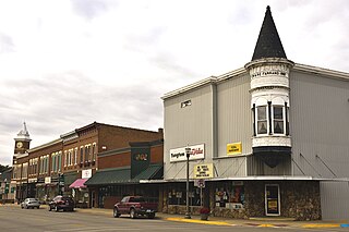
Shell Rock is a city in Butler County, Iowa, United States, along the Shell Rock River. The population was 1,268 at the time of the 2020 census. The city is located along the county's eastern border, between Butler and Bremer counties.
Delaware is a city in Delaware County, Iowa, United States. The population was 142 at the time of the 2020 census.
Hopkinton is a city in Delaware County, Iowa, United States. The population was 622 at the time of the 2020 census.
Sherrill is a city in Dubuque County, Iowa, United States. The population was 189 at the time of the 2020 census, up from 186 in 2000.
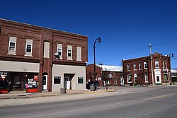
Marble Rock is a city in Floyd County, Iowa, United States, along the Shell Rock River. The population was 271 at the time of the 2020 census. Marble Rock has a city park, historical museums, a powerhouse on the river, and a veterans' memorial. The Marble Rock Historical Society has a website with information about the museums.
Rutland is a city in Humboldt County, Iowa, United States. The population was 113 at the time of the 2020 census.
Central City is a city in Linn County, Iowa, United States. The population was 1,264 at the 2020 census. It is part of the Cedar Rapids Metropolitan Statistical Area.
Liscomb is a city in Marshall County, Iowa, United States. The population was 291 at the time of the 2020 census.
Henderson is a city in Mills County, Iowa, United States. The population was 144 at the time of the 2020 census.
Chatsworth is a city in Sioux County, Iowa, United States. The population was 75 at the 2020 census.
Lincoln is a city in Tama County, Iowa, United States. The population was 121 at the time of the 2020 census. The community was known as Berlin until June 12, 1918.
Barnum is a city in Webster County, Iowa, United States, just off U.S. Route 20. The population was 175 at the 2020 census.
Clare is a city in Webster County, Iowa, United States. The population was 136 at the 2020 census. Clare was settled circa 1882 by immigrants from Clare County, Ireland. Clare is also home to a United States post office on West Front St.
Lawton is a city in Woodbury County, Iowa, Iowa, United States. It is part of the Sioux City metropolitan area. The population was 943 at the time of the 2020 census.
Oto is a city in Woodbury County, Iowa, United States. It is part of the Sioux City, IA–NE–SD Metropolitan Statistical Area. The population was 72 at the time of the 2020 census.
Western is a village in Saline County, Nebraska, United States. The population was 224 at the 2020 census.
Clearfield is a city in Taylor and Ringgold counties in the U.S. state of Iowa. The population was 278 at the time of the 2020 census.