North Washington, Iowa

Last updated
North Washington, Iowa
Chickasaw County Iowa Incorporated and Unincorporated areas North Washington Highlighted.svg
Location of North Washington, Iowa
Coordinates: 43°6′59″N92°24′55″W / 43.11639°N 92.41528°W / 43.11639; -92.41528 Coordinates: 43°6′59″N92°24′55″W / 43.11639°N 92.41528°W / 43.11639; -92.41528
Country Flag of the United States.svg  United States
State Flag of Iowa.svg  Iowa
County Chickasaw
Area
[1]
  Total0.20 sq mi (0.53 km2)
  Land0.20 sq mi (0.53 km2)
  Water0.00 sq mi (0.00 km2)
Elevation
1,142 ft (348 m)
Population
 (2020)
  Total112
  Density551.72/sq mi (213.22/km2)
Time zone UTC-6 (Central (CST))
  Summer (DST) UTC-5 (CDT)
ZIP code
50661
Area code 641
FIPS code 19-57495
GNIS feature ID0459642

North Washington is a city in Chickasaw County, Iowa, United States. The population was 112 at the time of the 2020 census. [2]

Contents

Geography

North Washington is located at 43°6′59″N92°24′55″W / 43.11639°N 92.41528°W / 43.11639; -92.41528 (43.116252, -92.415178). [3]

According to the United States Census Bureau, the city has a total area of 0.20 square miles (0.52 km2), all land. [4]

Demographics

Historical populations
YearPop.±%
1910 132    
1920 124−6.1%
1930 110−11.3%
1940 138+25.5%
1950 159+15.2%
1960 156−1.9%
1970 134−14.1%
1980 142+6.0%
1990 107−24.6%
2000 118+10.3%
2010 117−0.8%
2020 112−4.3%
Source: "U.S. Census website". United States Census Bureau . Retrieved 2020-03-29. and Iowa Data Center
Source:
U.S. Decennial Census [5] [2]

2010 census

Mainstreet, 1930 FI0003257 North Washington 1930.jpg
Mainstreet, 1930

As of the census [6] of 2010, there were 117 people, 43 households, and 31 families living in the city. The population density was 585.0 inhabitants per square mile (225.9/km2). There were 45 housing units at an average density of 225.0 per square mile (86.9/km2). The racial makeup of the city was 97.4% White, 1.7% African American, and 0.9% from other races. Hispanic or Latino of any race were 2.6% of the population.

There were 43 households, of which 44.2% had children under the age of 18 living with them, 65.1% were married couples living together, 2.3% had a female householder with no husband present, 4.7% had a male householder with no wife present, and 27.9% were non-families. 23.3% of all households were made up of individuals, and 4.6% had someone living alone who was 65 years of age or older. The average household size was 2.72 and the average family size was 3.19.

The median age in the city was 38.2 years. 29.9% of residents were under the age of 18; 8.6% were between the ages of 18 and 24; 22.2% were from 25 to 44; 31.6% were from 45 to 64; and 7.7% were 65 years of age or older. The gender makeup of the city was 52.1% male and 47.9% female.

2000 census

As of the census [7] of 2000, there were 118 people, 47 households, and 32 families living in the city. The population density was 601.2 inhabitants per square mile (232.1/km2). There were 49 housing units at an average density of 249.6 per square mile (96.4/km2). The racial makeup of the city was 98.31% White, and 1.69% from two or more races.

There were 47 households, out of which 53.2% had children under the age of 18 living with them, 57.4% were married couples living together, 6.4% had a female householder with no husband present, and 29.8% were non-families. 25.5% of all households were made up of individuals, and 17.0% had someone living alone who was 65 years of age or older. The average household size was 2.51 and the average family size was 3.03.

In the city, the population was spread out, with 31.4% under the age of 18, 6.8% from 18 to 24, 30.5% from 25 to 44, 19.5% from 45 to 64, and 11.9% who were 65 years of age or older. The median age was 34 years. For every 100 females, there were 107.0 males. For every 100 females age 18 and over, there were 88.4 males.

The median income for a household in the city was $38,542, and the median income for a family was $41,667. Males had a median income of $29,306 versus $26,250 for females. The per capita income for the city was $15,611. There were 7.9% of families and 5.8% of the population living below the poverty line, including 5.9% of under eighteens and 11.1% of those over 64.

Education

It is within the New Hampton Community School District. [8]

Notable person

Related Research Articles

<span class="mw-page-title-main">Eden Township, Lancaster County, Pennsylvania</span> Township in Pennsylvania, United States

Eden Township is a township in southeastern Lancaster County, Pennsylvania, United States. At the 2020 census the population was 2,248. It is part of the Solanco School District.

<span class="mw-page-title-main">Center Junction, Iowa</span> Census-designated place in Iowa, United States

Center Junction is an unincorporated village and census-designated place (CDP) in Jones County, Iowa, United States. The population was 111 at the 2010 census, at which time it was a city. It is part of the Cedar Rapids Metropolitan Statistical Area.

<span class="mw-page-title-main">Stephenson, Michigan</span> City in Michigan, United States

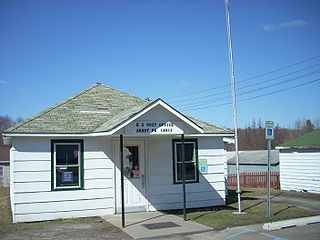
Stephenson is a city in Menominee County in the U.S. state of Michigan. The population was 862 at the 2010 census. The city is surrounded by Stephenson Township but is administered autonomously. It is part of the Marinette, WI–MI Micropolitan Statistical Area.

<span class="mw-page-title-main">Greenfield, Missouri</span> City in Missouri, United States

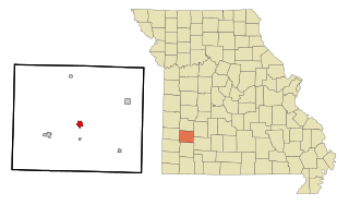
Greenfield is a city in Dade County, Missouri. The population was 1,220 at the 2020 census. It is the county seat of Dade County.

<span class="mw-page-title-main">Dakota City, Nebraska</span> City in Nebraska, United States

Dakota City is a city in Dakota County, Nebraska, United States. The population was 1,919 at the 2010 census. It is the county seat of Dakota County. Tyson Foods' largest beef production plant is located in Dakota City.

<span class="mw-page-title-main">Inglewood, Nebraska</span> Village in Nebraska, United States

Inglewood is a village in Dodge County, Nebraska, United States. The population was 325 at the 2010 census.

<span class="mw-page-title-main">Gilead, Nebraska</span> Village in Nebraska, United States

Gilead is a village in Thayer County, Nebraska, United States. The population was 39 at the 2010 census.

<span class="mw-page-title-main">Genola, Minnesota</span> City in Minnesota, United States

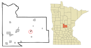
Genola is a city in Morrison County, Minnesota, United States. The population was 70 at the 2020 census.

<span class="mw-page-title-main">Mount Pleasant Township, Adams County, Pennsylvania</span> Township in Pennsylvania, United States

Mount Pleasant Township is a township in Adams County, Pennsylvania, in the United States. As of the 2010 census, the township population was 4,693.

<span class="mw-page-title-main">Paradise Township, Lancaster County, Pennsylvania</span> Township in Pennsylvania, United States

Paradise Township is a township in east-central Lancaster County, Pennsylvania, United States. The population was 5,696 at the 2020 census.

<span class="mw-page-title-main">Deer Creek Township, Mercer County, Pennsylvania</span> Township in Pennsylvania, United States

Deer Creek Township is a township in Mercer County, Pennsylvania, United States. The population was 456 at the 2020 census, a decline from the figure of 502 in 2010.

<span class="mw-page-title-main">Lake Township, Mercer County, Pennsylvania</span> Township in Pennsylvania, United States

Lake Township is a township in Mercer County, Pennsylvania, United States. The population was 702 at the 2020 census, a decline from the figure of 780 in 2010.

<span class="mw-page-title-main">New Vernon Township, Mercer County, Pennsylvania</span> Township in Pennsylvania, United States

New Vernon Township is a township in Mercer County, Pennsylvania, United States. The population was 492 at the 2020 census, down from 504 in 2010.

<span class="mw-page-title-main">Howe Township, Perry County, Pennsylvania</span> Township in Pennsylvania, United States

Howe Township is a township in Perry County, Pennsylvania, United States. The population was 375 at the 2020 census.

<span class="mw-page-title-main">Wheatfield Township, Perry County, Pennsylvania</span> Township in Pennsylvania, United States

Wheatfield Township is a township in Perry County, Pennsylvania, United States. The population was 3,194 at the 2020 census.

<span class="mw-page-title-main">Bloss Township, Tioga County, Pennsylvania</span> Township in Pennsylvania, United States

Bloss Township is a township in Tioga County, Pennsylvania, United States. The population was 344 at the 2020 census.

<span class="mw-page-title-main">Covington Township, Tioga County, Pennsylvania</span> Township in Pennsylvania, United States

Covington Township is a township in Tioga County, Pennsylvania, United States. The population was 1,031 at the 2020 census.

<span class="mw-page-title-main">Pine Grove Township, Warren County, Pennsylvania</span> Township in Pennsylvania, United States

Pine Grove Township is a township in Warren County, Pennsylvania, United States. As of the 2020 census, the township population was 2,615, down from 2,965 at the 2010 census.

<span class="mw-page-title-main">Pence, Wisconsin</span> Town in Wisconsin, United States

Pence is a town in Iron County, Wisconsin, United States. The population was 198 at the 2000 census. The census-designated place of Pence is located in the town. The unincorporated community of Germania is also located in the town.

Tikander Lake is an unorganized territory in Saint Louis County, Minnesota, United States. The population was 783 at the 2000 census.

References

  1. "2020 U.S. Gazetteer Files". United States Census Bureau. Retrieved March 16, 2022.
  2. 1 2 "2020 Census State Redistricting Data". census.gov. United states Census Bureau. Retrieved 12 August 2021.
  3. "US Gazetteer files: 2010, 2000, and 1990". United States Census Bureau. 2011-02-12. Retrieved 2011-04-23.
  4. "US Gazetteer files 2010". United States Census Bureau. Archived from the original on 2012-07-02. Retrieved 2012-05-11.
  5. "Census of Population and Housing". Census.gov. Retrieved June 4, 2015.
  6. "U.S. Census website". United States Census Bureau . Retrieved 2012-05-11.
  7. "U.S. Census website". United States Census Bureau . Retrieved 2008-01-31.
  8. "New Hampton" (PDF). Iowa Department of Education . Retrieved 2020-04-11.