An alvar is a biological environment based on a limestone plain with thin or no soil and, as a result, sparse grassland vegetation. Often flooded in the spring, and affected by drought in midsummer, alvars support a distinctive group of prairie-like plants. Most alvars occur either in northern Europe or around the Great Lakes in North America. This stressed habitat supports a community of rare plants and animals, including species more commonly found on prairie grasslands. Lichen and mosses are common species. Trees and bushes are absent or severely stunted.

The Bruce Peninsula is a peninsula in Ontario, Canada, that divides Georgian Bay of Lake Huron from the lake's main basin. The peninsula extends roughly northwestwards from the rest of Southwestern Ontario, pointing towards Manitoulin Island, with which it forms the widest strait joining Georgian Bay to the rest of Lake Huron. The Bruce Peninsula contains part of the geological formation known as the Niagara Escarpment.
Ontario Parks is the Ontario government agency in Ontario, Canada, that protects significant natural and cultural resources in a system of parks and protected areas that is sustainable and provides opportunities for inspiration, enjoyment and education. The Ontario Parks system covers over 78,000 square kilometres (30,000 sq mi), which is about 10 percent of the province's surface area or the equivalent of an area approximately equal to Nova Scotia. It falls under the responsibility and mandate of the province's Ministry of the Environment, Conservation and Parks. It was formerly under the mandate of the Ministry of Natural Resources and Forestry.
Lion's Head may refer to:

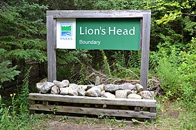
Lion's Head is a community in the municipality of Northern Bruce Peninsula, Bruce County, Ontario, Canada. It is located at the midway point of the Bruce Peninsula, about halfway between Owen Sound and Tobermory, just east of Ferndale on Bruce Road 9. Lion's Head is located on the 45th parallel north, halfway between the Equator and the North Pole. The town is named after the resemblance of a lion's profile in the rock formation of the Niagara Escarpment. The first post office opened in 1895.
Mitlenatch Island Nature Provincial Park is a provincial park in British Columbia, Canada, located on Mitlenatch Island a small islet in the northern Strait of Georgia within the Strathcona Regional District.

Lady Evelyn-Smoothwater Provincial Park is a remote wilderness park in northeastern Ontario, Canada, north of Lake Temagami. It is one of five provincial parks located in the Temagami area.
White Lake Provincial Park is a park in the Thunder Bay District of Northern Ontario, Canada, along Highway 17, north of Lake Superior.

Alexander Stewart Provincial Park is a nature reserve in McNab/Braeside, Renfrew County, Ontario, Canada, about 11 kilometres (7 mi) west of the centre of Arnprior. This nature reserve contains a hardwood forest of several species including maple, American beech, basswood, blue-beech, and bur oak. The subsurface is clay silt, a remnant of the ice age Champlain Sea. The site is at an elevation of 130 metres (430 ft).

The Municipality of Northern Bruce Peninsula is located on the Bruce Peninsula in Bruce County, Ontario, Canada. It is a popular vacation spot in the summer for its water sports and cottaging, and in the winter for snowmobiling. The municipality was formed on January 1, 1999, when the townships of St. Edmunds, Lindsay, and Eastnor, as well as the Village of Lion's Head, were amalgamated.

Foy Provincial Park is a provincial park on Round Lake, Ontario. Since it is non-operational, camping is prohibited, but day use activities such as swimming and hiking are permitted. The park property includes facilities used by the Ontario Ranger program of the Ministry of Natural Resources.

Bonheur River Kame Provincial Park is an 800-hectare (2,000-acre) provincial nature reserve in Ontario, Canada. It is approximately 35 kilometres (22 mi) east of the town of Ignace, and north of Burk Township. It became a nature reserve in 1985 via provincial legislation, primarily to protect the kame it contains, which is an important earth science feature.
Sedgman Lake Provincial Park, operated by Ontario Parks is located in the District of Thunder Bay, Ontario. Sedgman Lake was named May 5, 1960 in honour of World War II casualty Private Alfred Thomas Sedgman who died while serving in the Canadian Army on February 26, 1945.

Arrowhead Provincial Park is located north of Huntsville, Ontario, Canada, and is part of the Ontario Parks system. A portion of the shoreline of Glacial Lake Algonquin is visible in the park.

The Burnt Lands is an alvar between Almonte and Ottawa near Upper Huntley, Ontario, Canada. It probably obtained its name from one of the forest fires that swept the area during early European settlement.
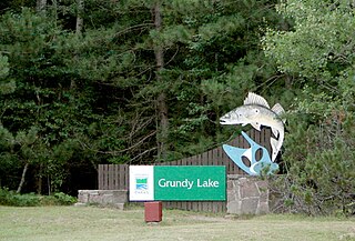
Grundy Lake Provincial Park in Ontario, Canada, is a natural environment park established in 1959 and is part of the Ontario Parks system. The park is located near Britt, at the junction of Highway 69 and Highway 522.

The Centennial Lake Provincial Nature Reserve is a provincial park located in the municipality of Greater Madawaska, Renfrew County, in Eastern Ontario, Canada. The 530-hectare (1,300-acre) reserve was created in 1989 and is managed by Ontario Parks.
Gravel River Provincial Park is a nature reserve in the Thunder Bay District of Ontario, Canada. It protects an unusual birds-foot delta at the mouth of the Gravel River.

Egan Chutes Provincial Park is located 15 km (9.3 mi) east of Bancroft, Ontario, Canada. It was established as a provincial park in 1989 but is a non-operating park. Egan chutes is classified as a nature reserve, protecting a section of the York River.