Cyclones in India
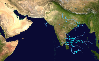
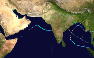
The Intertropical Convergence Zone may affect thousands of Indians living in the coastal regions. Tropical cyclogenesis is particularly common in the northern reaches of the Indian Ocean in and around the Bay of Bengal. Cyclones bring with them heavy rains, storm surges, and winds that often cut affected areas off from relief and supplies. In the North Indian Ocean Basin, the cyclone season runs from April to December, with peak activity between May and November. [8] Each year, an average of eight storms with sustained wind speeds greater than 63 kilometres per hour (39 mph) form; of these, two strengthen into true tropical cyclones, which have sustained gusts greater than 117 kilometres per hour (73 mph). On average, a major (Category 3 or higher) cyclone develops every other year. [9] [10]
During summer, the Bay of Bengal is subject to intense heating, giving rise to humid and unstable air masses that produce cyclones. Many powerful cyclones, including the 1737 Calcutta cyclone, the 1970 Bhola cyclone, the 1991 Bangladesh cyclone, the 1999 Odisha cyclone, and 2019s Cyclone Fani in Odisha and Cyclone Vayu in Gujarat, have led to widespread devastation along parts of the eastern coast of India and neighboring Bangladesh. Widespread death and property destruction are reported every year in exposed Tamil Nadu, and West Bengal. India's western coast, bordering the more placid Arabian Sea, experiences cyclones only rarely; these mainly strike Gujarat and, less frequently, Kerala and sometimes Odisha.
In terms of damage and loss of life, the 1999 Odisha cyclone, a super cyclone that struck Odisha on 29 October 1999, was the worst in more than a quarter-century. With peak winds of 160 miles per hour (257 km/h), it was the equivalent of a Category 5 hurricane. [11] Almost two million people were left homeless; [12] another 20 million people's lives were disrupted by the cyclone. [12] Officially, 9,803 people died from the storm; [11] unofficial estimates place the death toll at over 10,100. [12]
In terms of damage and asset destruction, Cyclone Amphan, [13] a super cyclone that struck West Bengal, Odisha and Bangladesh on 20 May 2020 is, as of that date, the worst in India in the 21st century. With peak winds of 260 kilometres per hour (162 mph) to 280 kilometres per hour (174 mph), it was the equivalent of a Category 5 hurricane. [11] Almost 5 million (50 lakh) people are left homeless in West Bengal, Odisha and Bangladesh ; [13] another 10 million (1 crore) people's lives were disrupted by the cyclone. Officially, 128 people died from the storm. Official damage and asset destruction estimate is 13.40 to 13.69 billion US Dollars ; [14] it is the costliest and most damaging cyclone ever to occur in the Bay of Bengal.
2021 Cyclone Tauktae killed at least 104 people, the highest in a decade. [15]

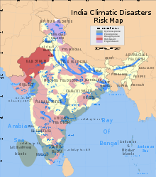
The climate of India consists of a wide range of weather conditions across a vast geographic scale and varied topography. Based on the Köppen system, India hosts six major climatic sub types, ranging from arid deserts in the west, alpine tundra and glaciers in the north, and humid tropical regions supporting rain forests in the southwest and the island territories. Many regions have starkly different microclimates, making it one of the most climatically diverse countries in the world. The country's meteorological department follows the international standard of four seasons with some local adjustments: winter, summer, monsoon or rainy season, and a post-monsoon period.

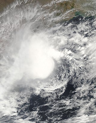
In the Indian Ocean north of the equator, tropical cyclones can form throughout the year on either side of the Indian subcontinent, although most frequently between April and June, and between October and December.
The 2005 North Indian Ocean cyclone season caused much devastation and many deaths in Southern India despite the storms’ weakness. The basin covers the Indian Ocean north of the equator as well as inland areas, sub-divided by the Arabian Sea and the Bay of Bengal. Although the season began early with two systems in January, the bulk of activity was confined from September to December. The official India Meteorological Department tracked 12 depressions in the basin, and the unofficial Joint Typhoon Warning Center (JTWC) monitored two additional storms. Three systems intensified into a cyclonic storm, which have sustained winds of at least 63 km/h (39 mph), at which point the IMD named them.

The 1992 North Indian Ocean cyclone season was unofficially the most active year on record for the basin, with 10 tropical storms developing, according to the Joint Typhoon Warning Center (JTWC). There are two main seas in the North Indian Ocean – the Bay of Bengal to the east of the Indian subcontinent – and the Arabian Sea to the west of India. The official Regional Specialized Meteorological Centre in this basin is the India Meteorological Department (IMD), while the JTWC releases unofficial advisories. An average of four to six storms form in the North Indian Ocean every season with peaks in May and November. Cyclones occurring between the meridians 45°E and 100°E are included in the season by the IMD.

The 2006 North Indian Ocean cyclone season had no bounds, but cyclones tend to form between April and December, with peaks in May and November. These dates conventionally delimit the period of each year when most tropical cyclones form in the northern Indian Ocean.

The 2004 North Indian Ocean cyclone season was the first in which tropical cyclones were officially named in the basin. Cyclone Onil, which struck India and Pakistan, was named in late September. The final storm, Cyclone Agni, was also named, and crossed into the southern hemisphere shortly before dissipation. This storm became notable during its origins and became one of the storms closest to the equator. The season was fairly active, with ten depressions forming from May to November. The India Meteorological Department designated four of these as cyclonic storms, which have maximum sustained winds of at least 65 km/h (40 mph) averaged over three minutes. The Joint Typhoon Warning Center also issued warnings for five of the storms on an unofficial basis.

The 2003 North Indian Ocean cyclone season was the last season that tropical cyclones were not publicly labeled by India Meteorological Department (IMD). Also was mostly focused in the Bay of Bengal, where six of the seven depressions developed. The remaining system was a tropical cyclone that developed in the Arabian Sea in November, which was also the only system that did not affect land. There were three cyclonic storms, which was below the average of 4–6. Only one storm formed before the start of the monsoon season in June, although it was also the most notable. On May 10, a depression formed in the central Bay of Bengal, and within a few days became a very severe cyclonic storm. After it stalled, it drew moisture from the southwest to produce severe flooding across Sri Lanka, killing 254 people and becoming the worst floods there since 1947. Damage on the island totaled $135 million (2003 USD). The storm eventually made landfall in Myanmar on May 19. It is possible that the storm contributed to a deadly heat wave in India due to shifting air currents.

The 2000 North Indian Ocean cyclone season was fairly quiet compared to the year before, 1999 North Indian Ocean cyclone season, with all of the activity originating in the Bay of Bengal. The basin comprises the Indian Ocean north of the equator, with warnings issued by the India Meteorological Department (IMD) in New Delhi. There were six depressions throughout the year, of which five intensified into cyclonic storms – tropical cyclones with winds of 65 mph (105 km/h) sustained over 3 minutes. Two of the storms strengthened into a Very Severe Cyclonic Storm, which has winds of at least 120 km/h (75 mph), equivalent to a minimal hurricane. The Joint Typhoon Warning Center (JTWC) also tracked storms in the basin on an unofficial basis, estimating winds sustained over 1 minute.
The 1995 North Indian Ocean cyclone season was below-average and was primarily confined to the autumn months, with the exception of three short-lived deep depressions in May. There were eight depressions in the basin, which is Indian Ocean north of the equator. The basin is subdivided between the Bay of Bengal and the Arabian Sea on the east and west coasts of India, respectively. Storms were tracked by the India Meteorological Department (IMD), which is the basin's Regional Specialized Meteorological Center, as well as the American-based Joint Typhoon Warning Center (JTWC) on an unofficial basis.

The 1990 North Indian Ocean cyclone season featured a below average total of twelve cyclonic disturbances and one of the most intense tropical cyclones in the basin on record. During the season the systems were primarily monitored by the India Meteorological Department, while other warning centres such as the United States Joint Typhoon Warning Center also monitored the area. During the season, there were at least 1,577 deaths, while the systems caused over US$693 million in damages. The most significant system was the 1990 Andhra Pradesh cyclone, which was the most intense, damaging, and the deadliest system of the season.

The climate of Asia is dry across its southwestern region. Some of the largest daily temperature ranges on Earth occur in the western part of Asia. The monsoon circulation dominates across the southern and eastern regions, due to the Himalayas forcing the formation of a thermal low which draws in moisture during the summer. The southwestern region of the continent experiences low relief as a result of the subtropical high pressure belt; they are hot in summer, warm to cool in winter, and may snow at higher altitudes. Siberia is one of the coldest places in the Northern Hemisphere, and can act as a source of arctic air mass for North America. The most active place on Earth for tropical cyclone activity lies northeast of the Philippines and south of Japan, and the phase of the El Nino-Southern Oscillation modulates where in Asia landfall is more likely to occur. Many parts of Asia are being impacted by climate change.

India is a country in the north of Indian Ocean that is the most vulnerable to getting hit by tropical cyclones in the basin, from the east or from the west. On average, 2–3 tropical cyclones make landfall in India each year, with about one being a severe tropical cyclone or greater.
In May 2003, a tropical cyclone officially called Very Severe Cyclonic Storm BOB 01 produced the worst flooding in Sri Lanka in 56 years. The first storm of the 2003 North Indian Ocean cyclone season, it developed over the Bay of Bengal on May 10. Favorable environmental conditions allowed the system to intensify steadily while moving northwestward. The storm reached peak maximum sustained winds of 140 km/h (85 mph) on May 13, making it a very severe cyclonic storm according to the India Meteorological Department (IMD), which is the official Regional Specialized Meteorological Center for the basin. The cyclone drifted north over the central Bay of Bengal, gradually weakening due to heightened wind shear. Turning eastward, the storm deteriorated to a deep depression on May 16 before it curved northeastward and re-intensified into a cyclonic storm. It came ashore in western Myanmar and dissipated over land the following day.

The 2015 North Indian Ocean cyclone season was an event in the annual cycle of tropical cyclone formation. The North Indian Ocean cyclone season has no official bounds, but cyclones tend to form between months of April and December, with the peak from May to November. These dates conventionally delimit the period of each year when most tropical cyclones form in the northern Indian Ocean.

The 2016 North Indian Ocean cyclone season was an event in the annual cycle of tropical cyclone formation. It was the deadliest season since 2010, killing more than 400 people. The season was an average one, seeing four named storms, with one further intensifying into a very severe cyclonic storm. The first named storm, Roanu, developed on 19 May while the season's last named storm, Vardah, dissipated on 18 December. The North Indian Ocean cyclone season has no official bounds, but cyclones tend to form between April and December, with the two peaks in May and November. These dates conventionally delimit the period of each year when most tropical cyclones form in the northern Indian Ocean.

Cyclonic Storm Roanu was a relatively weak tropical cyclone that caused severe flooding in Sri Lanka and Bangladesh during May 2016. It is the first tropical cyclone of the annual cyclone season. Roanu originated from a low-pressure area that formed south of Sri Lanka, which gradually drifted north and intensified into a cyclonic storm on 19 May. However, wind shear and land interaction caused it to weaken slightly, before reintensifying as it accelerated towards the coast of Bangladesh.

The 2018 North Indian Ocean cyclone season was one of the most active North Indian Ocean cyclone seasons since 1992, with the formation of fourteen depressions and seven cyclones. The North Indian Ocean cyclone season has no official bounds, but cyclones tend to form between April and December, with the two peaks in May and November. These dates conventionally delimit the period of each year when most tropical cyclones form in the northern Indian Ocean.

The 2019 North Indian Ocean cyclone season was the second most active North Indian Ocean cyclone season on record in terms of cyclonic storms, the 1992 season was more active according to the Joint Typhoon Warning Center. The season featured 12 depressions, 11 deep depressions, 8 cyclonic storms, 6 severe cyclonic storms, 6 very severe cyclonic storms, 3 extremely severe cyclonic storms, and 1 super cyclonic storm, Kyarr, the first since Cyclone Gonu in 2007. Additionally, it also became the third-costliest season recorded in the North Indian Ocean, only behind the 2020 and 2008 seasons.

During 2017 tropical cyclones formed within seven different tropical cyclone basins, located within various parts of the Atlantic, Pacific and Indian Oceans. During the year, a total of 146 tropical cyclones had formed. 88 tropical cyclones had been named by either a Regional Specialized Meteorological Center (RSMC) or a Tropical Cyclone Warning Center (TCWC). The strongest and deadliest tropical cyclone was Hurricane Maria with a minimum barometric pressure of 908 mbar and killing 3,000 people in Puerto Rico and Dominica. The costliest tropical cyclone of the year was Hurricane Harvey in the Atlantic, which struck Houston metropolitan area in August causing US$125 billion in damage, tying with Hurricane Katrina as the costliest tropical cyclone worldwide.

Very Severe Cyclonic Storm Titli was a deadly and destructive tropical cyclone that caused extensive damage to Eastern India in October 2018. Titli was the twelfth depression and fifth named storm to form in the 2018 North Indian Ocean cyclone season. Titli originated from a low pressure area in the Andaman Sea on October 7. With warm sea surface temperatures and low wind shear, the low developed into a depression on October 8 in the central Bay of Bengal. It was tracked and followed by the India Meteorological Department (IMD), which also issued warnings and notices for the public. Titli continued to intensify at it moved toward the southeast Indian coast, becoming a very severe cyclonic storm, equivalent to a minimal hurricane on the Saffir–Simpson scale. It attained the intensity at the same time Cyclone Luban in the Arabian Sea was at the same intensity, marking the first instance since 1977 of simultaneous storms. The IMD estimated peak winds of 150 km/h (95 mph), while the American-based Joint Typhoon Warning Center (JTWC) estimated peak winds of 195 km/h (120 mph). Late on October 10, Titli made landfall in Andhra Pradesh, and it quickly weakened over land as it turned to the northeast. It degenerated into a remnant low on October 12.