West Rand District Municipality

Last updated
West Rand
West Rand CoA.png
Map of Gauteng with West Rand highlighted.svg
Location in Gauteng
Coordinates: 26°15′S27°30′E / 26.250°S 27.500°E / -26.250; 27.500
Country South Africa
Province Gauteng
Seat Randfontein
Local municipalities
Government
[1]
  Type Municipal council
  MayorThabiso Bovungana (AIC)
Area
  Total4,087 km2 (1,578 sq mi)
Population
 (2011) [2]
  Total820,995
  Density200/km2 (520/sq mi)
Racial makeup (2011)
[2]
   Black African 79.2%
   Coloured 2.5%
   Indian/Asian 1.1%
   White 16.7%
First languages (2011)
[2]
   Tswana 27.3%
   Afrikaans 16.9%
   Xhosa 14.9%
   Sotho 10.8%
  Other30.1%
Time zone UTC+2 (SAST)
Municipal codeDC48

The West Rand District Municipality (Tswana : Mmasepala wa Sedika wa West Rand; Afrikaans : Wesrand-distriksmunisipaliteit; Xhosa : uMasipala weSithili sase West Rand; Sotho : Masepala wa Setereke wa West Rand) [1] is one of the districts of the Gauteng province of South Africa, that covers the West Rand area, with the exception of Roodepoort. The seat of the district municipality is Randfontein. [3] [4] As of 2011, the most spoken language among its population of 820,995 is Tswana. The district code is CBDC8.

Contents

Geography

Neighbours

West Rand is surrounded by:

Local municipalities

The district contains the following local municipalities:

NameCodeSeatArea
(km²) [5]
Population
(2016) [6]
Pop. density
(per km²)
Merafong City GT484 Carletonville 1,631188,843115.8
Mogale City GT481 Krugersdorp 1,342383,864286.0
Rand West City GT485 Randfontein 1,115265,887238.5

Demographics

The following statistics are from the 2011 census.

LanguagePopulation%
Tswana 215 50724.96%
Afrikaans 126 33816.98%
Xhosa 123 50116.60%
Sotho 86 23611.59%
Zulu 63 5418.54%
Tsonga 38 4105.16%
English 35 8114.81%
Northern Sotho 22 6183.04%
Other 10 5871.42%
Swati 9 9181.33%
Venda 8 9271.20%
Ndebele 2 7590.37%

Gender

GenderPopulation%
Male400 15753.77%
Female344 01146.23%

Ethnic group

Ethnic groupPopulation%
Black African587 66578.84%
White132 84917.85%
Coloured17 5312.36%
Indian/Asian7 1230.96%

Age

AgePopulation%
000 - 00463 0628.47%
005 - 00955 9837.52%
010 - 01455 7467.49%
015 - 01958 7217.89%
020 - 02472 8689.79%
025 - 02982 60111.10%
030 - 03477 61610.43%
035 - 03976 42510.27%
040 - 04465 4128.79%
045 - 04946 4796.25%
050 - 05431 1534.19%
055 - 05919 8262.66%
060 - 06414 4591.94%
065 - 0699 0581.22%
070 - 0746 5260.88%
075 - 0794 1770.56%
080 - 0842 5610.34%
085 - 0898970.12%
090 - 0943950.05%
095 - 0991300.02%
100 plus730.01%

Politics

Election results

Election results for the West Rand District Municipality in the 2021 South African municipal elections.

PartyVotes%
African National Congress 79 55943.82%
Democratic Alliance 48 33726.62%
Economic Freedom Fighters 28 50815.70%
Freedom Front Plus 11 7496.47%
African Independent Congress 2 7791.53%
Patriotic Alliance 1 9781.09%
African Christian Democratic Party 1 6930.93%
African Transformation Movement 1 1780.65%
Pan Africanist Congress of Azania 1 1340.62%
United Democratic Movement 1 0170.56%
Congress Of The People 9500.52%
Randfontein Peoples Party 8540.47%
Forum 4 Service Delivery 6530.36%
National Freedom Party 4150.23%
Activists Movement of South Africa 3390.19%
Justice And Employment Party 3180.18%
African Covenant 1140.06%
Total181 575100.00%

Related Research Articles

<span class="mw-page-title-main">City of Ekurhuleni Metropolitan Municipality</span> Metropolitan Municipality in Gauteng, South Africa

The City of Ekurhuleni Metropolitan Municipality is a metropolitan municipality that forms the local government of the East Rand region of Gauteng, a large suburban region east of Johannesburg. Ekurhuleni means "place of peace" in XiTsonga. Ekurhuleni is one of the five districts of Gauteng and one of the eight metropolitan municipalities of South Africa. The seat of Ekurhuleni is Germiston and the most spoken language is Zulu at 28.6%. The city is home to South Africa's busiest airport, OR Tambo International Airport, which is in the Kempton Park area of Ekurhuleni.

<span class="mw-page-title-main">Ngaka Modiri Molema District Municipality</span> District municipality in North West, South Africa

The Ngaka Modiri Molema District Municipality, formerly the Central District Municipality, is one of the four districts of the North West province of South Africa. Its capital is Mafikeng, which is also the capital of the province.

<span class="mw-page-title-main">Frances Baard District Municipality</span> District municipality in Northern Cape, South Africa

The Frances Baard District Municipality, previously the Diamantveld District Municipality, is one of the 5 districts of the Northern Cape province of South Africa. The seat of the municipality is Kimberley. As of 2011, the majority of its 324,814 residents speak Setswana. The district code is DC9.

<span class="mw-page-title-main">ZF Mgcawu District Municipality</span> District municipality in Northern Cape, South Africa

The ZF Mgcawu District Municipality, known before 1 July 2013 as the Siyanda District Municipality, is one of the 5 districts of the Northern Cape province of South Africa. The seat of the municipality is Upington. As of 2011, the majority (76%) of its 236,783 residents speak Afrikaans. The district code is DC8.

<span class="mw-page-title-main">Bojanala Platinum District Municipality</span> District municipality in North West, South Africa

The Bojanala Platinum District Municipality is one of the 4 districts of the North West province of South Africa. The seat of the municipality is Rustenburg. As of 2011, a majority of its 1,507,505 residents spoke Setswana. The district code is DC37.

<span class="mw-page-title-main">Dr Kenneth Kaunda District Municipality</span> District municipality in North West, South Africa

The Dr Kenneth Kaunda District Municipality, formerly the Southern District Municipality, is one of the 4 districts of the North West province of South Africa. The seat of the municipality is Klerksdorp. As of 2016, a plurality of its 742,821 residents speak Setswana. The majority of its residents live in the City of Matlosana. The district code is DC40. The district was formerly known as the Southern District Municipality. It is named after Kenneth Kaunda, the first President of Zambia.

<span class="mw-page-title-main">Dr Ruth Segomotsi Mompati District Municipality</span> District municipality in North West, South Africa

The Dr Ruth Segomotsi Mompati District Municipality, formerly the Bophirima District Municipality, is one of the 4 districts of the North West province of South Africa. The seat of the municipality is Vryburg. As of 2011, the majority of its 439,637 residents speak Setswana. The district code is DC39. It is South Africa's largest beef producing district, with Hereford cattle the most popular. It is sometimes called "the Texas of South Africa". Maize and peanuts are important crops produced in the district. The district was renamed after the former Mayor of Vryburg, Ruth Mompati.

<span class="mw-page-title-main">Waterberg District Municipality</span> District Municipality in Limpopo, South Africa

The Waterberg District Municipality is one of the 5 districts of the Limpopo province of South Africa. The seat is Modimolle. As of 2016, the majority of its 745,758 residents spoke Sepedi, also known as Northern Sotho. The district code is DC36.

<span class="mw-page-title-main">Merafong City Local Municipality</span> Local municipality in Gauteng, South Africa

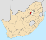
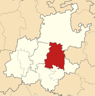
Merafong City Municipality is a local municipality in the West Rand District Municipality, in the Gauteng province of South Africa. Its boundaries encloses some of the richest gold mines in the world. It is situated about 65 km from Johannesburg and is serviced by a number of major roads, including the N12 from Johannesburg to Beaufort West and the N14.

<span class="mw-page-title-main">Mogale City Local Municipality</span> Local municipality in Gauteng, South Africa

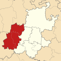
Mogale City Local Municipality is a local municipality within the West Rand District Municipality, in the Gauteng province of South Africa.

<span class="mw-page-title-main">Lephalale Local Municipality</span> Local municipality in Limpopo, South Africa

Lephalale Municipality is a local municipality within the Waterberg District Municipality, in the Limpopo province of South Africa. The seat is Lephalale.

<span class="mw-page-title-main">Mahikeng Local Municipality</span> Local municipality in North West, South Africa

Mahikeng Municipality is a local municipality within the Ngaka Modiri Molema District Municipality, in the North West province of South Africa. Mahikeng is a Setswana word meaning "place of rocks".

<span class="mw-page-title-main">City of Matlosana</span> Local municipality in North West, South Africa

The City of Matlosana, formerly the City Council of Klerksdorp, is a local municipality within the Dr Kenneth Kaunda District Municipality, in the North West province of South Africa.

<span class="mw-page-title-main">Naledi Local Municipality, North West</span> Local municipality in North West, South Africa

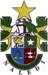
Naledi Municipality is a local municipality within the Dr Ruth Segomotsi Mompati District Municipality, in the North West province of South Africa. The seat of the municipality is Vryburg.

<span class="mw-page-title-main">Mamusa Local Municipality</span> Local municipality in North West, South Africa

Mamusa Municipality is a local municipality within the Dr Ruth Segomotsi Mompati District Municipality, in the North West province of South Africa. The seat of the municipality is Schweizer-Reneke.

<span class="mw-page-title-main">Ratlou Local Municipality</span> Local municipality in North West, South Africa

Ratlou Municipality, formerly Setla-Kgobi Municipality, is a local municipality within the Ngaka Modiri Molema District Municipality, in the North West province of South Africa.

<span class="mw-page-title-main">Ramotshere Moiloa Local Municipality</span> Local municipality in North West, South Africa

Ramotshere Moiloa Municipality, formerly Zeerust Municipality, is a local municipality within the Ngaka Modiri Molema District Municipality, in the North West province of South Africa. The seat of the municipality is Zeerust.

<span class="mw-page-title-main">Tswelopele Local Municipality</span> Local municipality in Free State, South Africa

Tswelopele Municipality is a local municipality within the Lejweleputswa District Municipality, in the Free State province of South Africa. Tswelopele is a Sesotho word meaning "progress".

<span class="mw-page-title-main">Kai ǃGarib Local Municipality</span> Local municipality in Northern Cape, South Africa

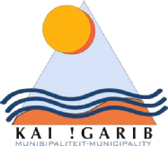
Kai ǃGarib Municipality is a local municipality within the ZF Mgcawu District Municipality, in the Northern Cape province of South Africa. The name Kai ǃGarib originates from the Khoekhoe language and means "big great river", referring to the Orange River that flows through the area.

<span class="mw-page-title-main">Rand West City Local Municipality</span> Local municipality in Gauteng, South Africa

Rand West City Municipality is a local municipality in the Gauteng province of South Africa. It was established after the August 2016 local elections by merging the Randfontein and Westonaria local municipalities. It is a division of the West Rand District Municipality.

References

  1. 1 2 "West Rand District Municipality | Government Communication and Information System (GCIS)". www.gcis.gov.za. Government Communication and Information System. Retrieved 20 June 2017.
  2. 1 2 3 "Statistics by place". Statistics South Africa. Retrieved 27 September 2015.
  3. "West Rand District Municipality". www.localgovernment.co.za. Yes Media. Retrieved 20 June 2017.
  4. "West Rand District Municipality Contact". www.wrdm.gov.za. West Rand District Municipality. Retrieved 20 June 2017.
  5. "2016 Boundaries". Municipal Demarcation Board (Shapefile). 2016.
  6. "Community Survey 2016". Statistics South Africa (Data file). 2016.