The M1 motorway is a motorway in Ireland. It forms the large majority of the N1 national primary road connecting Dublin towards Belfast along the east of the island of Ireland. The route heads north via Swords, Drogheda and Dundalk to the Northern Irish border just south of Newry in County Armagh, where it joins the A1 road and further on, the M1 motorway in Northern Ireland. It also forms a significant part of the road connection between Dublin and the Northern Irish cities of Newry, and Lisburn. The route is part of European route E01.

The N3 is a national route in South Africa that connects Johannesburg and Durban, respectively South Africa's largest and third-largest cities. Johannesburg is the financial and commercial heartland of South Africa, while Durban is South Africa's key port and one of the busiest ports in the Southern Hemisphere and is also a holiday destination. Durban is the port through which Johannesburg imports and exports most of its goods. As a result, the N3 is a very busy highway and has a high volume of traffic.

Johannesburg is heavily dependent upon freeways for transport around the city due to its location 1,500 metres above sea level, far from the coast or any major bodies of water. There are 10 freeways in the Greater Johannesburg Metropolitan Area: the N1, N3, N12, N14, N17, R21, R24, R59, M1 and M2. In addition, three new freeways are planned: the G5, G9 and G14. Freeways are sometimes called highways or motorways colloquially.
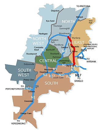
The N3 Eastern Bypass is a section of the Johannesburg Ring Road that forms a beltway around the city of Johannesburg, South Africa, as part of the N3. The first section of the freeway opened in 1971, from Buccleuch to the interchange with Main Reef Road in Germiston. This is one reason why Germiston is listed as the southbound destination of this route, from the Buccleuch to Geldenhuys Interchanges, rather than to the Elands Interchange south of Germiston. The remaining section from Main Reed Road to Black Reef Road, which included the construction of the Geldenhuys Interchange, was opened in 1977, linking the Eastern Bypass with the N3 freeway to Heidelberg. The interchange at Main Reef Road was removed.

The Western Bypass is a section of the N1 and the Johannesburg Ring Road located in the city of Johannesburg, South Africa. Known at the time as the Concrete Highway, the freeway was initially opened in 1975 as a route to avoid the city centre of Johannesburg and to provide access to the western areas of the Witwatersrand. From the south, the Western Bypass begins at the Diepkloof Interchange in Soweto, where it splits from the N12 freeway and ends at the Buccleuch Interchange, where it merges with the N3 Eastern Bypass, M1 South and N1 Ben Schoeman freeways.

The N12 Southern Bypass is a section of the Johannesburg Ring Road that forms a beltway around the city of Johannesburg, South Africa, as part of the N12. The freeway was the last section of the Ring Road to be built, with the final section opening in 1986. As part of the old South African Freeways, It was initially called the N13. The entire Southern Bypass freeway is an e-toll highway.

The N1 is a national route in South Africa that runs from Cape Town through Bloemfontein, Johannesburg, Pretoria and Polokwane to Beit Bridge on the border with Zimbabwe. It forms the first section of the famed Cape to Cairo Road.

The suburbs of Johannesburg are officially demarcated areas within the City of Johannesburg Metropolitan Municipality, South Africa. As in other Commonwealth countries, the term suburb refers to a "neighbourhood", although in South Africa most "suburbs" have legally recognised borders and often separate postal codes. The municipal functions for the area, such as municipal policing and social services, are still managed by the city government.

The R55 is a north-south provincial route in Gauteng, South Africa that connects Sandton with Pretoria. It passes Woodmead, Kyalami, Olievenhoutbosch, Heuweloord, Sunderland Ridge, Erasmia, Laudium/Claudius, West Park, the Daspoort Tunnel and Danville. It connects with the M1, N14, and R80 highways. It is also designated as the P66-1 and K71 by the Gauteng Provincial Government.

The R82 is a provincial route in South Africa that connects Johannesburg with Kroonstad via Vereeniging and Sasolburg. It starts just south of the M1 Johannesburg Municipal Highway's interchange with the N12 Southern Bypass, going south, meeting the R59, R54, R42 & R28 routes at Vereeniging before crossing the Vaal River into the Free State & proceeding to Kroonstad. It is an alternative, but longer route to the N1 National Route between Johannesburg & Kroonstad.
Randpark is a suburb of Randburg, South Africa. It is located in the northern suburbs of the City of Johannesburg.
The M1 De Villiers Graaff motorway is a metropolitan route and major freeway in the City of Johannesburg, South Africa. The highway connects the southern areas with the city centre and extends further north through Sandton into the Ben Schoeman Highway towards Pretoria. Construction began in 1962 and resulted in the demolition of many properties and houses including numerous historical Parktown Mansions.
The M2 is a major highway and metropolitan route in Greater Johannesburg, South Africa. It is named the Francois Oberholzer Freeway. It runs just to the south of the Johannesburg Central Business District eastwards where it connects with the N3 and enters Germiston, ending near its CBD. The north–south M1 intersects with the M2 just to the south-west of the Johannesburg CBD.

The N12 is a national route in South Africa which runs from George through Beaufort West, Kimberley, Klerksdorp and Johannesburg to eMalahleni.
Beyers Naudé Drive is a large arterial route in Johannesburg, South Africa. It starts at the University of Johannesburg in Auckland Park, travelling through Melville, Roosevelt Park, Northcliff, Blackheath and traversing the N1 Western Bypass at Randpark Ridge. It terminates at the N14 freeway near Muldersdrift. It was previously known as DF Malan Drive. It forms part of Johannesburg's M5 road.
The R101 is a Regional Route in South Africa that is the designation for some of the old sections of roads that were previously the N1, prior to upgrading. It only has 2 sections, from Bellville to Worcester and from Johannesburg to Polokwane.

The Ben Schoeman Freeway or Ben Schoeman Highway is the main freeway between Johannesburg and Pretoria, and consists of portions of the M1, N1, and N14. Opened in 1968, it is named after former Minister of Transport Ben Schoeman, and is undoubtedly the busiest road in South Africa.
The R564 is a Regional Route in the City of Johannesburg Metropolitan Municipality in Gauteng, South Africa. It connects Roodepoort with Buccleuch via Northriding and Fourways.
M71 is a major metropolitan route in the City of Johannesburg, South Africa. Starting in the northern CBD, it connects the centre of Johannesburg with the northern suburbs before ending in the outer northern city of Midrand.
The M68 is a short metropolitan route in the City of Johannesburg, South Africa. It connects the south-western part of Soweto with Mulbarton via Diepkloof, Southgate and Glenvista.

