Whitstran, Washington

Last updated
Whitstran, Washington
Whitstran Spur
Unincorporated community

Whitstran Washington - looking east - July 2013.JPG

Looking east in Whitstran.
Benton County Washington Incorporated and Unincorporated areas.svg
Red pog.svg
Whitstran, Washington
Location of Whitstran, Washington
Coordinates: 46°14′07″N119°42′20″W / 46.2354111°N 119.7055870°W / 46.2354111; -119.7055870 Coordinates: 46°14′07″N119°42′20″W / 46.2354111°N 119.7055870°W / 46.2354111; -119.7055870 [1]
Country United States
State Washington
County Benton
Elevation 679 ft (207 m)
Time zone Pacific (PST) (UTC-8)
  Summer (DST) PDT (UTC-7)
ZIP code 99350
Area code(s) 509
FIPS code 53-78540
GNIS feature ID 1512805 [2]
1915 topographical map depicting previous place name of Valley Heights 1915 USGS Topo Prosser.jpg
1915 topographical map depicting previous place name of Valley Heights
1926 Road map 1926 Automobile Roads-Horse Heaven Quadrangle.jpg
1926 Road map

Whitstran is a small, unincorporated community in Benton County, Washington, located approximately four miles Northeast of Prosser and approximately ten miles west of Benton City. The focal point of the community is at the intersection of North Rothrock Road and Foisy Road, where there is a small grocery store, and nearby Whitstran Elementary School.

Unincorporated area Region of land not governed by own local government

In law, an unincorporated area is a region of land that is not governed by a local municipal corporation; similarly an unincorporated community is a settlement that is not governed by its own local municipal corporation, but rather is administered as part of larger administrative divisions, such as a township, parish, borough, county, city, canton, state, province or country. Occasionally, municipalities dissolve or disincorporate, which may happen if they become fiscally insolvent, and services become the responsibility of a higher administration. Widespread unincorporated communities and areas are a distinguishing feature of the United States and Canada. In most other countries of the world, there are either no unincorporated areas at all, or these are very rare; typically remote, outlying, sparsely populated or uninhabited areas.

Benton County, Washington County in the United States

Benton County is a county in the south-central portion of the U.S. state of Washington. As of the 2010 census, its population was 175,177. The county seat is Prosser, and its largest city is Kennewick. The Columbia River demarcates the county's north, south, and east boundaries.

Prosser, Washington City in Washington, United States

Prosser is a city in and the county seat of Benton County, Washington, United States, along the Yakima River with only one zip code 99350. The population was 5,714 at the 2010 census.

Contents

History

The settlement of Valley Heights originated in 1907 when Seattle developer Charles Jorgen Smith, purchased property in present-day Whitstran, which became known as Valley Heights Orchard Tracts. [3] It was also called Swede Settlement for a time because of a number of Scandinavians who purchased property in the area. A rail line was built in 1911 and a town site was platted by Mary Biggam. By 1919 the community began to be known as Whitstran and the name Valley Heights eventually faded from use. [4]

The community's name was changed to Whitstran by the Northern Pacific Railway in honor of two retired railroad nurses, Laura Whitaker and May A. Strangeways, who were cousins who developed a small acreage nearby. [5]

Northern Pacific Railway transport company

The Northern Pacific Railway was a transcontinental railroad that operated across the northern tier of the western United States, from Minnesota to the Pacific Northwest. It was approved by Congress in 1864 and given nearly forty million acres of land grants, which it used to raise money in Europe for construction.

Another source indicates that the town was named by the North Yakima and Valley Railway Company in honor of a landowner from whom a right-of-way had been acquired. The railway station was previously known as Whitstran Spur. [6]

E.W. Fry built the first store in Whitstran in 1916. Jim McCorkle has owned the store, now known as McCorkle's, since 1993. Previously it was known as Blake's Corner Market and Whitstran Trading Company. [7]

In the 1950s, a new school replaced the previous one room school. [7] The school is now Whitstran Elementary School.

Schools

Related Research Articles

Yakima, Washington City in Washington, United States

Yakima is a city in and the county seat of Yakima County, Washington, and the state's eleventh-largest city by population. As of the 2010 census, the city had a total population of 91,067 and a metropolitan population of 243,231. The unincorporated suburban areas of West Valley and Terrace Heights are considered a part of greater Yakima.

Kennewick, Washington City in Washington, United States

Kennewick is a city in Benton County in the southeastern part of the State of Washington, along the southwest bank of the Columbia River, just southeast of the confluence of the Columbia and Yakima rivers and across from the confluence of the Columbia and the Snake River. It is the most populous of the three cities collectively referred to as the Tri-Cities. The population was 73,917 at the 2010 census. July 1, 2017 estimates from the Census Bureau put the city's population at 81,607.

Interstate 82 (I-82) is an Interstate Highway in the Pacific Northwest region of the United States that travels through parts of Washington and Oregon. It runs 144 miles (232 km) from Ellensburg, Washington, to Hermiston, Oregon, passing through Yakima and the Tri-Cities. The highway also connects I-90 and I-84, which continue to Seattle and Boise, Idaho, respectively.

Thorp, Washington unincorporated community & census-designated place in Washington, United States

Thorp is an unincorporated community and census-designated place (CDP) in Kittitas County, Washington, United States. The population was 240 at the 2010 census. The surrounding area had a population of 695 as of the 2010 census.

West Seattle neighborhood in Seattle

West Seattle comprises two of the thirteen districts of the city of Seattle, Washington and encompasses all of Seattle west of the Duwamish River. It was incorporated as an independent town in 1902 before being annexed by Seattle five years later. Among the area's attractions are its saltwater beach parks along Elliott Bay and Puget Sound, including Alki Beach Park and Lincoln Park. The area is also known for its views of the Olympic Mountains to the west and the Cascade Range to the east. One-third of Seattle's green space and urban forest is located in West Seattle, much of it in the West Duwamish Greenbelt.

Wellington, Washington Unincorporated community in Washington, United States

Wellington was a small unincorporated community and railroad community in the northwest United States, on the Great Northern Railway in northeastern King County, Washington.

State Route 22 (SR 22) is a 35.84-mile (57.68 km) long state highway spanning Yakima and Benton counties in the US state of Washington. Existing since at least 1937, the highway serves to connect several small communities that have been bypassed by Interstate 82 (I-82) / U.S. Route 12 (US 12). Except for the section through Toppenish and the southeastern bypass of Prosser, the highway is lightly traveled passing mainly through rural farmland. The highway parallels a BNSF Railway line for a majority of its route, with the rail line predating the highway by at least 27 years.

Yakima Valley AVA

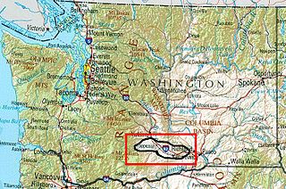
The Yakima Valley AVA was the first American Viticultural Area established within Washington State, gaining the recognition in 1983. Part of the larger Columbia Valley AVA, Yakima Valley AVA is home to more than 11,000 acres (45 km2) of vineyards, giving the area the largest concentration of wineries and vineyards in the state of Washington. The most widely planted varietals in the area are Chardonnay, Riesling, Merlot, Cabernet Sauvignon, Pinot gris, and Syrah. Nearly 40% of Washington state yearly wine production is made from Yakima Valley grapes. In addition to grapes, the Yakima Valley is also home to several fruit orchards growing apples, cherries, nectarines, peaches, pears and plums. Around the town of Zillah, there is the Zillah Fruit Loop driving tour through the area's orchards and vineyards. The area is also home to nearly 80% of the US hop production.

Kiona, Washington Unincorporated community in Washington, United States

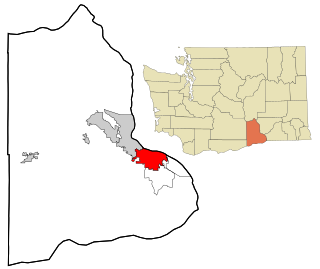
Kiona is an unincorporated community in Benton County, Washington, United States. Kiona is a term belonging to North American indigenous people meaning "brown hills." Kiona and Benton City share a school district.

Mike Burns (basketball) American basketball player-coach

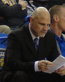
Michael Edward Burns is an American college basketball coach who is currently an assistant men's basketball coach at Boise State.

Horse Heaven Hills Hill range in eastern Washington State.

The Horse Heaven Hills are a long range of high, rolling hills in Klickitat, Yakima, and Benton counties in Washington. The hills are an anticline ridge in the Yakima Fold Belt formed by north–south compression of lava flows in the Columbia River Basalt Group. The highest point is Bickleton Ridge in the west end of the hills. They lie within the rain shadow to the east of the Cascade Range, making them significantly drier and hotter than regions west of the Cascades.

Washington State Route 221 highway in Washington

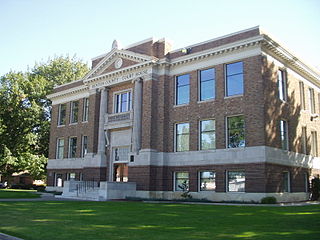
State Route 221 (SR 221) is a 25.95-mile (41.76 km) long state highway located entirely within Benton County, Washington, United States. The highway serves to connect the unincorporated community of Paterson to the county seat Prosser. The highway has existed since at least 1926 and was designated as Primary State Highway 8E from 1937 until the 1964 renumbering of Washington state highways.

Joseph J. Tyson Catholic bishop

Joseph Jude Tyson is an American prelate of the Roman Catholic Church who is currently the Bishop of the Diocese of Yakima, Washington. He served as an auxiliary bishop of the Archdiocese of Seattle from 2005–2011.

Apricot, Washington Unincorporated community in Washington, United States

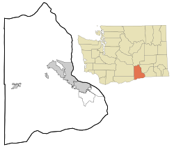
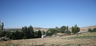
Apricot is an unincorporated community in Benton County, Washington, United States, located between Prosser and Grandview.

Byron, Washington Unincorporated community in Washington, United States

Byron is an unincorporated community in Yakima County, Washington, United States, located approximately three miles west of Prosser.

2014 United States House of Representatives elections in Washington

The 2014 United States House of Representatives elections in Washington were held on Tuesday, November 4, 2014 to elect the ten U.S. Representatives from the state of Washington, one from each of the state's ten congressional districts. The state certified the results on December 4. The nonpartisan blanket primary election was held on August 5, with the top two candidates for each position advancing to the general election.

References

  1. "Whitstran". Geographic Names Information System . United States Geological Survey . Retrieved 2012-10-29.
  2. "US Board on Geographic Names". United States Geological Survey. 2007-10-25. Retrieved 2008-01-31.
  3. Bagley, Clarence (1916). History of Seattle from the earliest settlement to the present time (Volume 3). Chicago, IL: S.J. Clarke Publishing Company.
  4. Davis; Bergum. "Washington Place Names database". p. 73. Retrieved 13 July 2011.
  5. Davis; Bergum. "Washington Place Names database". pp. 80–81. Retrieved 13 July 2011.
  6. "Station Roster Master List: Whitstran". Northern Pacific Railway Historic Association. Retrieved 13 July 2011.
  7. 1 2 Courtney, Ross (March 28, 2004). "Not Much Left for Whitstran but the Stores". Yakima-Herald Republic. Retrieved 13 July 2011.