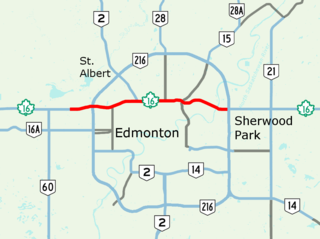
Alberta Provincial Highway No. 16, commonly referred to as Highway 16, is a major east–west highway in central Alberta, Canada, connecting Jasper to Lloydminster via Edmonton. It forms a portion of the Yellowhead Highway, a major interprovincial route of the Trans-Canada Highway system that stretches from Masset, British Columbia to Portage la Prairie, Manitoba, near Winnipeg. Highway 16 spans approximately 634 km (394 mi) from Alberta's border with British Columbia in the west to its border with Saskatchewan in the east. As of 2010, all but less than 96 km (60 mi) of the route was divided, with a minimum of two lanes in each direction. It is designated a core route in Canada's National Highway System.

Alberta Provincial Highway No. 16A, commonly referred to as Highway 16A, is the designation of three alternate routes off Alberta Highway 16 in Alberta, Canada. The Evansburg – Entwistle section is called 16A:08 by Alberta Transportation, while 16A:24 runs through Vegreville. The section west of Edmonton is labelled 16A:14 and 16A:16 on Alberta Transportation maps, but is better known as Parkland Highway and Stony Plain Road.

Memorial Drive is a major road in Calgary, Alberta. Aside from its important role in city infrastructure, the tree lined sides of Memorial Drive serve as a living testament to the many local soldiers who died during World War I and give it a parkway look on the western section. An active path system also runs along the south side of Memorial Drive, beside the banks of the Bow River. The Calgary Soldiers' Memorial forms part of an extensive renovation to Memorial Drive, which heightens the function of the road as a monument to the city's military. The Landscape of Memory Project began in 2004, in order to revitalize a nine kilometre stretch of the road. The design incorporated "Poppy Plaza" at the corner of Memorial Drive and 10th Street NW. The plaza used "weathered steel" to create large gateways, and the plaza and adjacent river walk were lined with the same rusted metal into which quotes about the Canadian experiences of war were cut. The Peace Bridge was incorporated into the remembrance theme of Memorial Drive, though there are no explanatory plaques at the site of the bridge.

Jasper Avenue is an arterial road in central Edmonton, Alberta, and is the city's main street. Jasper Avenue has no official street number but is aligned with 101 Avenue with the majority of its length. Jasper Avenue is a major public transit route as several of Edmonton's busiest bus routes travel along it. The LRT travels underneath Jasper Avenue between 99 and 110 Streets. It is named after Jasper Hawes, manager of a North West Company trading post of Jasper House in the early 1800s, located in present-day Jasper National Park.
Stony Plain Road is an expressway and arterial road Edmonton, Alberta. Parkland Highway is an alternative route to the corresponding section of Highway 16 in Parkland County.
170 Street is a major arterial road in west Edmonton, Alberta. It serves residential, commercial and industrial areas. Gervais Road / Hebert Road is a major arterial road in south St. Albert, Alberta, Canada. It serves residential and commercial areas.
Terwillegar Drive is a developing freeway in south-west Edmonton, Alberta. It is under construction, with the majority of its intersection at-grade, it retains its arterial road status. Once completed, it will be the third freeway in Edmonton not to have a highway designation after Groat Road and Wayne Gretzky Drive. South of Windermere Boulevard the roadway goes by 170 Street SW.
23 Avenue NW is a major arterial road in south Edmonton. It runs through several neighbourhoods including Mill Woods and The Meadows, and commercial areas including South Edmonton Common, and Mill Woods Town Centre. In September 2011, construction completed of an interchange at the intersection with Calgary Trail & Gateway Boulevard (Highway 2); considered Edmonton's busiest intersection. Because Edmonton has adapted a quadrant system, the suffix NW is sometimes added to addresses, to avoid confusion with addresses south of Quadrant (1) Avenue.

111 Street is a major arterial road in south Edmonton, Alberta, Canada. The south leg of the LRT runs between the northbound and southbound lanes north of 23 Avenue. It passes by Southgate Centre and the former location of Heritage Mall, now the location of the Century Park transit-oriented development.
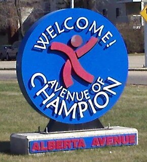
118 Avenue is the designated name of two major arterial roads in central Edmonton, Alberta, Canada, separated by the Edmonton City Centre Airport. The west side services both an industrial area, and a residential area, while the east 118 Avenue, originally Alberta Avenue, is one of the oldest streets in Edmonton outside the downtown core. The name was changed to 118 Avenue in 1914 with the adoption of the grid system. Historically, it was a route between the City of Edmonton in the west and the Town of Beverly in the east. It is also sometimes called the Avenue of Champions. When Beverly was still a separate community from Edmonton, the portion of Alberta Avenue in Beverly was the central business district. Beverly amalgamated with Edmonton on December 31, 1961. Following the amalgamation, Beverly's central business district went into a period of decline. The avenue boasts several major landmarks, including Northlands and the Coliseum.
97/98/101 Avenue and Baseline Road is a major arterial road in central Edmonton and north Sherwood Park, Alberta. It connects Downtown Edmonton with the mature residential neighborhoods on the city's eastern edge, as well as Refinery Row and Sherwood Park.
97 Street is a major arterial road in north Edmonton, Alberta. It is used to take vehicles in and out of Downtown Edmonton to the city's northern suburban neighbourhoods and to the region's main military installation, CFB Edmonton. North of Yellowhead Trail, it is designated as part of Highway 28.

105 Street is an arterial road in Downtown Edmonton, Alberta, Canada. It starts across the North Saskatchewan River from Downtown, as one-way streets Walterdale Hill and Queen Elizabeth Park Road, which join and continue north on Walterdale Bridge. At 100 Avenue, 105 Street becomes a two-way street, and continues through Downtown past MacEwan University.
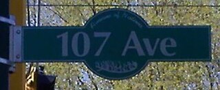
107 Avenue is a major arterial road in west-central Edmonton, Alberta, Canada. It serves Edmonton's west side industrial district, neighbourhoods of the former Town of Jasper Place, the multicultural area north of Downtown Edmonton, Commonwealth Stadium, and adjacent park & ride transit centre. The portion between 95 and 116 Streets has been dubbed "Avenue of Nations", as immigrants from around the world live in this area, including African Nations, Arabic Nations, Cambodia, China, First Nations, Italy, Japan, Latin American, Poland, Ukraine, and Vietnam. Also, Chinatown lies just south of Avenue of Nations. 107 Avenue changes names at 101 Street to 107A Avenue. 107A Avenue changes names at 92 Street to Stadium Road. Stadium Road changes names at 112 Avenue to 86 Street .
Mayfield Road, 111 Avenue , and 112 Avenue is a major arterial road in north Edmonton, Alberta. It serves Edmonton's Northwest Industrial District, the former Town of Jasper Place, the inner city north Downtown Edmonton, and post-World War II Edmonton. Prior to the opening of Yellowhead Trail in the early 1980s, Highway 16 followed Mayfield Road and 111 Avenue between Stony Plain Road and 109 Street.
Mill Woods Road, together with 38 Avenue NW, is a ring road in the neighbourhood of Mill Woods, Edmonton, Alberta, Canada. Although Mill Woods is bisected by a number of numbered arterials, Mill Woods has utilized a newer form of residential and street design by building this inner neighbourhood ring, which acts as a collector for the curved and named residential streets.
Yellowhead Trail is a 24.6-kilometre (15.3 mi) expressway segment of the Yellowhead Highway in northern Edmonton, Alberta, Canada. It carries a significant amount of truck traffic to and from the industrial areas of north Edmonton and serves as a key commuter route for the bedroom communities of Stony Plain, Spruce Grove, and Sherwood Park, carrying nearly 80,000 vehicles per weekday in 2015. A suburban bypass of the route was completed when the northeast leg of Anthony Henday Drive (Highway 216) opened in late 2016, providing an alternate route through north Edmonton.
124 Street is an arterial road in north-central Edmonton, Alberta. It is known for being one Edmonton's main shopping districts and historical commercial corridor for the original west end of Edmonton; home to independent restaurants, art galleries, and boutiques, as well as 19th-century heritage houses. Prior to Edmonton adopting its present street numbering system in 1914, it was known as 24th Street with the unofficial name of Edward Street.