West Jasper Place, Edmonton

Last updated
West Jasper Place
Neighbourhood
2008-08-18 MacEwan College JP Campus.jpg
The Orange Hub (formerly the MacEwan University Centre for the Arts) is located in West Jasper Place
Edmonton agglomeration-blank.svg
Red pog.svg
West Jasper Place
Location of West Jasper Place in Edmonton
Coordinates: 53°32′13″N113°35′06″W / 53.537°N 113.585°W / 53.537; -113.585
CountryFlag of Canada (Pantone).svg  Canada
Province Flag of Alberta.svg  Alberta
City Edmonton
Quadrant [1] NW
Ward [1] Nakota Isga
Sector [2] Mature area
Area [3] [4] Jasper Place
Government
[5]
  Administrative body Edmonton City Council
  CouncillorAndrew Knack
Area
[6]
  Total0.89 km2 (0.34 sq mi)
Elevation
673 m (2,208 ft)
Population
 (2012) [7]
  Total2,966
  Density3,332.6/km2 (8,631/sq mi)
  Change (2009–12)
Decrease2.svg−2.9%
  Dwellings
1,696

West Jasper Place is a residential neighbourhood in west Edmonton, Alberta, Canada. Originally part of the Town of Jasper Place, West Jasper Place became a part of Edmonton when Edmonton and Jasper Place amalgamated on August 17, 1964.

Contents

While most of the neighbourhood is residential, there is some commercial development, with most of this adjacent to Stony Plain Road at the neighbourhood's north end. This development includes the Jasper Gates shopping centre.

The neighbourhood is bounded by 149 Street on the east, 95 Avenue on the south, 156 Street on the west, and Stony Plain Road on the North.

The community is represented by the West Jasper/Sherwood Community League. Which maintains a community hall, outdoor rink and tennis courts located at 152 Street and 96 Avenue. [8] [9] The West Jasper Place Community League operated as a separate entity from 1950 until 1985 when it merged with the Sherwood Community League. [9]

Demographics

In the City of Edmonton's 2012 municipal census, West Jasper Place had a population of 2,966 living in 1,696 dwellings, [7] a -2.9% change from its 2009 population of 3,055. [10] With a land area of 0.89 km2 (0.34 sq mi), [6] it had a population density of 3,332.6 people/km2 in 2012. [7] [6]

According to the 2005 municipal census, one in five (17.9%) of the population moved into the neighbourhood within the previous 12 months. Another one in four (23.9%) had moved within the previous one to three years. Only two out of every five (42.7%) had lived at the same address for five years or more. [11] This is similar to the city at large. [12]

Just over half (51%) were male and just under half (49%) were female.

Residential development

According to the 2001 federal census, just under one third (29.4%) of the residential dwellings in the neighbourhood were built prior to the 1964 amalgamation of Jasper Place and Edmonton, with a significant number of those being built prior to the 1945 end of World War II. Approximately half (48.2%) of the residences were built between 1960 and 1980. The remaining 22.4% were built after 1980, with a particular spike in residential construction occurring in a short span during the early 1990s, when one in ten (11.7%) of residences were constructed. [12]

In 2005, three out of every five residences (59.3%) were rented apartments, including a small number of apartment style condominiums. Most of these are in low rise buildings with fewer than five stories. Another third of the residences (35.5%) were single detached houses. A small number (5%) were duplexes. [11]

Approximately two out of every three (68%) of all residences are rented. [11]

Schools

Sherwood Elementary School was operated by the Edmonton Public School System. This school was purchased by Conseil scolaire Centre-Nord and will reopen in 2024 as a K-6 francophone school. [13]

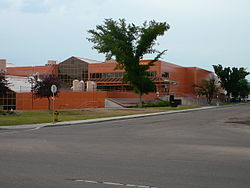
The Centre for the Arts Campus (formerly Jasper Place Campus) of MacEwan University was located near the north west corner of the neighbourhood. This building is now known as the Orange Hub and houses the Yellowhead Tribal College.

Parks and green space

There is a single park in the neighbourhood, Arthur Elliot Park.

Bike trails in the MacKinnon Ravine, located just across 149 Street in the Crestwood neighbourhood, provide access to the city's River Valley Park System.

Surrounding neighbourhoods

Adjacent neighbourhoods are Crestwood, Parkview, Sherwood, Meadowlark Park, Glenwood, Britannia-Youngstown, Canora and Grovenor. These are all residential neighbourhoods.

See also

Related Research Articles

<span class="mw-page-title-main">Strathearn, Edmonton</span> Neighbourhood in Edmonton, Alberta, Canada

Strathearn is a roughly triangular shaped residential neighbourhood in south central Edmonton, Alberta, Canada. Most of the development in Strathearn dates to the 1940s and 1950s.

<span class="mw-page-title-main">Oliver, Edmonton</span> Neighbourhood in Edmonton, Alberta, Canada

Oliver is one of the oldest residential neighbourhoods in the City of Edmonton, Alberta, Canada. The southeast portion of the neighbourhood is also known as Grandin, with both Grandin station (now known as Government Centre station and Grandin School located in this part of the neighbourhood.

<span class="mw-page-title-main">Britannia Youngstown, Edmonton</span> Neighbourhood in Edmonton, Alberta, Canada

Britannia Youngstown is a residential neighbourhood in west Edmonton, Alberta, Canada. Originally part of the Town of Jasper Place, it became part of Edmonton when Jasper Place amalgamated with Edmonton in 1964.

Meadowlark Park is a residential neighbourhood in west Edmonton, Alberta, Canada. Bounded by 95 Avenue to the north, 156 Street to the east, 87 Avenue to the south, and 163 Street to the west, the neighbourhood was originally part of the Town of Jasper Place. It became part of Edmonton in 1964 when Jasper Place amalgamated with the city.

Canora is a residential neighbourhood in west Edmonton, Alberta, Canada. Canora's name comes from the first two letters of the words "Canadian Northern Railway", the winning entry in a 1948 contest to name a new school being built near an abandoned right of way of the former Canadian Northern Railway.

Crestwood is a residential neighbourhood in west Edmonton, Alberta, Canada, overlooking the North Saskatchewan River valley and nestled between two ravines.

<span class="mw-page-title-main">Jasper Park, Edmonton</span> Neighbourhood in Edmonton, Alberta, Canada

Jasper Park is a neighbourhood in west Edmonton, Alberta, Canada that was once a part of the Town of Jasper Place. It became a part of Edmonton when Jasper Place amalgamated with Edmonton in 1964. It is a smaller residential neighbourhood bounded on the south by 87 Avenue, on the east by 149 Street, on the west by 156 Street, and on the north by 92 Avenue.

West Meadowlark Park is a residential neighbourhood in west Edmonton, Alberta, Canada located just east of West Edmonton Mall. The area was originally part of the Town of Jasper Place, and became a part of Edmonton when Jasper Place amalgamated with Edmonton in 1964.

Sherwood is a small neighbourhood in west Edmonton, Alberta, Canada. Originally part of the Town of Jasper Place, it became a part of Edmonton when Jasper Place amalgamated with Edmonton in 1964.

<span class="mw-page-title-main">Glenwood, Edmonton</span> Neighbourhood in Edmonton, Alberta, Canada

Glenwood is a large neighbourhood in west Edmonton, Alberta, Canada. The neighbourhood has a mixture of residential and commercial development. Glenwood became a part of Edmonton in 1964, when the Town of Jasper Place amalgamated with Edmonton.

High Park is a neighbourhood in west Edmonton, Alberta, Canada. The neighbourhood became a part of Edmonton when the Town of Jasper Place amalgamated with Edmonton in 1964.

Parkview is a residential neighbourhood in west Edmonton, Alberta, Canada. Parkview is one of the larger residential neighbourhoods in the city, and is located adjacent to the North Saskatchewan River Valley in the west portion of the City. The neighbourhood has good access to Whitemud Drive and Stony Plain Road, and the interior street layout is based on a modified grid network.

<span class="mw-page-title-main">Grovenor, Edmonton</span> Neighbourhood in Edmonton, Alberta, Canada

Grovenor is a residential neighbourhood in west Edmonton, Alberta, Canada. It was originally called Westgrove and a professional building on 142 Street still uses that name.

Westmount is an established central-west residential neighbourhood in Edmonton, Alberta, Canada. It is geographically close to the downtown core.

Kenilworth is a residential neighbourhood in south east Edmonton, Alberta, Canada located just to the north of Whyte Avenue.

Lendrum Place is a residential neighbourhood located in south west Edmonton, Alberta, Canada. It is named for Robert Lendrum, an early land surveyor.

<span class="mw-page-title-main">Belmead, Edmonton</span> Neighbourhood in Edmonton, Alberta, Canada

Belmead is a residential neighbourhood in west Edmonton, Alberta, Canada. Residents in Belmead live just to the west of West Edmonton Mall, the largest shopping centre in Canada. A portion of the neighbourhood, from 188 Street to 190 Street, is called Park West.

Empire Park is a residential neighbourhood in southwest Edmonton, Alberta, Canada. A major shopping centre, Southgate Centre, is located at the west end of the Neighbourhood.

King Edward Park is a residential neighbourhood on south east Edmonton, Alberta, Canada. The neighbourhood was originally annexed by Edmonton in 1912.

Killarney is a residential neighbourhood located in north east Edmonton, Alberta, Canada. While the area became part of Edmonton in 1913, residential development did not occur until the 1950s and 1960s.

References

  1. 1 2 "City of Edmonton Wards & Standard Neighbourhoods" (PDF). City of Edmonton. Retrieved February 13, 2013.
  2. "Edmonton Developing and Planned Neighbourhoods, 2011" (PDF). City of Edmonton. Retrieved February 13, 2013.
  3. "The Way We Grow: Municipal Development Plan Bylaw 15100" (PDF). City of Edmonton. 2010-05-26. Retrieved February 13, 2013.
  4. "City of Edmonton Plans in Effect" (PDF). City of Edmonton. November 2011. Retrieved February 13, 2013.
  5. "City Councillors". City of Edmonton. Retrieved February 13, 2013.
  6. 1 2 3 "Neighbourhoods (data plus kml file)". City of Edmonton. Retrieved February 22, 2013.
  7. 1 2 3 "Municipal Census Results – Edmonton 2012 Census". City of Edmonton. Retrieved February 22, 2013.
  8. "West Jasper/Sherwood Community League". West Jasper/Sherwood Community League. Retrieved October 14, 2017.
  9. 1 2 Kuban, Ron (2005). Edmonton's Urban Villages: The Community League Movement . University of Alberta Press. ISBN   9781459303249.
  10. "2009 Municipal Census Results". City of Edmonton. Retrieved February 22, 2013.
  11. 1 2 3 2005 Municipal Census: Structure Type: West Jasper Place (PDF) (Report). The City of Edmonton. 2005.{{cite report}}: Unknown parameter |agency= ignored (help)
  12. 1 2 2005 Municipal Census: Length of Residence: Edmonton (PDF) (Report). The City of Edmonton. 2005.{{cite report}}: Unknown parameter |agency= ignored (help)
  13. https://ici.radio-canada.ca/nouvelle/2058504/ecole-primaire-edmonton-cscn