Royal Gardens, Edmonton

Last updated
Royal Gardens
Neighbourhood
Edmonton agglomeration-blank.svg
Red pog.svg
Royal Gardens
Location of Royal Gardens in Edmonton
Coordinates: 53°28′48″N113°31′44″W / 53.480°N 113.529°W / 53.480; -113.529
CountryFlag of Canada (Pantone).svg  Canada
Province Flag of Alberta.svg  Alberta
City Edmonton
Quadrant [1] NW
Ward [1] papastew
Sector [2] Mature area
Government
[3]
  Administrative body Edmonton City Council
  CouncillorMichael Janz
Area
[4]
  Total1.22 km2 (0.47 sq mi)
Elevation
670 m (2,200 ft)
Population
 (2012) [5]
  Total3,481
  Density2,853.3/km2 (7,390/sq mi)
  Change (2009–12)
Decrease2.svg−1.9%
  Dwellings
1,461

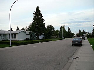
Royal Gardens is a residential neighbourhood in south west Edmonton, Alberta, Canada. The neighbourhood is bounded on the north by Whitemud Drive, on the east by 111 Street, on the south by 40 Avenue, and on the west by 119 Street/121 Street.

Contents

The residents of the community have public transportation access to the LRT system at Southgate Station.

The community is represented by the Royal Gardens Community League, established in 1968, which maintains a community hall, outdoor rink and tennis courts located at 117 Street and 40 Avenue. [6] [7]

Demographics

In the City of Edmonton's 2012 municipal census, Royal Gardens had a population of 3,481 living in 1,461 dwellings, [5] a -1.9% change from its 2009 population of 3,550. [8] With a land area of 1.22 km2 (0.47 sq mi), it had a population density of 2,853.3 people/km2 in 2012. [4] [5]

Residential development

Most of the residential development in the neighbourhood occurred during the 1960s when, according to the 2001 federal census, two out of every three (66.2%) of the residences were built. Another one in four (23.3%) of residences were built during the 1970s. [9]

According to the 2005 municipal census, the neighbourhood has a mixture of dwelling types with the most common type of residence being the single-family dwelling. Single-family dwellings account for two out of every five (43%) of all residences in the neighbourhood. Another one in three residences (34%) are rented apartments and apartment style condominiums. One in five (19%) of residences are row houses. The remaining 4% are duplexes, triplexes, or quadruplexes. Three out of five residences (57%) are owner-occupied while two out of five (43%) are rented. [9]

Population mobility

The population of Royal Gardens is comparatively mobile. According to the 2005 municipal census, one in five residents (20.7%) had moved within the previous 12 months. Another one in four residents (23.6%) had moved within the previous one to three years. At the same time, two out of every five residents (43.9%) had lived at the same address for at least five years. [9]

Schools and recreation facilities

There are four schools in the neighbourhood. Richard Secord School and Harry Ainlay High School are both operated by the Edmonton Public School System. St. Bonifice Catholic Elementary School and Louis St. Laurent School are operated by the Edmonton Catholic School System.

The Confederation Pool is located in the neighbourhood.

Shopping and services

Residents of Royal Gardens have good access to shopping. Southgate Centre, a major shopping mall, is located to the immediate north east. Whitemud Drive provides access to West Edmonton Mall. In addition, there is the Petrolia Shopping Centre in the neighbourhood of Greenfield to the south.

Surrounding neighbourhoods

See also

Related Research Articles

<span class="mw-page-title-main">Lynnwood, Edmonton</span> Neighbourhood in Edmonton, Alberta, Canada

Lynnwood is a residential neighbourhood in west Edmonton, Alberta, Canada. Its location gives residents good access to downtown, the University of Alberta, MacEwan College, and West Edmonton Mall. It became a part of Edmonton when the Town of Jasper Place amalgamated with Edmonton in 1964.

Lansdowne is a neighbourhood in south west Edmonton, Alberta, Canada overlooking the Whitemud Creek Ravine. The Snow Valley Ski Hill is located near the neighbourhood. The neighbourhood is situated directly across from Michener Park, a residential complex for students staying at the University of Alberta.

Malmo Plains is a residential neighbourhood in south west Edmonton, Alberta, Canada. The University of Alberta family residences, called Michener Park, comprise the west end of the neighbourhood. The neighbourhood is named for a type of soil, malmo silty clay loam, common in the area.

Greenfield, also known as Petrolia, is a residential neighbourhood located in southwest Edmonton, Alberta, Canada. While the official name of the neighbourhood is Greenfield, some residents will refer to the area as Petrolia. There is a small shopping centre, Petrolia Shopping Centre, located in the neighbourhood. The neighbourhood was named for Herbert Greenfield, the Premier of Alberta from 1921 to 1925, during the reign of the United Farmers of Alberta political party.

Parkview is a residential neighbourhood in west Edmonton, Alberta, Canada. Parkview is one of the larger residential neighbourhoods in the city, and is located adjacent to the North Saskatchewan River Valley in the west portion of the City. The neighbourhood has good access to Whitemud Drive and Stony Plain Road, and the interior street layout is based on a modified grid network.
<span class="mw-page-title-main">Laurier Heights, Edmonton</span> Neighbourhood in Edmonton, Alberta, Canada

Laurier Heights is a residential neighbourhood in west Edmonton, Alberta, Canada overlooking the North Saskatchewan River valley. A portion of the neighbourhood along Buena Vista Road is located in the river valley, and this portion is sometimes called Buena Vista.

Duggan is a residential neighbourhood in south Edmonton, Alberta, Canada. The neighbourhood is "named for J.J. Duggan ".

Prince Rupert is a triangle-shaped residential neighbourhood in north west Edmonton, Alberta, Canada. Prince Rupert is located within the old Hudson's Bay Reserve and was developed after the end of World War II. The neighbourhood is bounded on the south by 111 Avenue, on the west by 121 Street, and on the northeast by Kingsway Avenue.

<span class="mw-page-title-main">Thorncliff, Edmonton</span> Neighbourhood in Edmonton, Alberta, Canada

Thorncliff is a neighbourhood in west Edmonton, Alberta, Canada located immediately to the south of West Edmonton Mall. According to the neighbourhood description in the City of Edmonton Map Utility. the neighbourhood was designed to control urban sprawl and improve the delivery of services. Whitemud Drive, located just to the south of the neighbourhood, provides good access to destinations on the south side, including the University of Alberta, Fort Edmonton Park, and the Southgate Centre shopping mall.

Aspen Gardens is a residential neighbourhood in south west Edmonton, Alberta, Canada, overlooking the Whitemud Creek Ravine. The neighbourhood "was designed to appeal to individuals and families in search of quiet, affluent residential neighbourhood characterised by larger homes, mature trees, and attractive paths for pedestrian and bicycle travel."

Lymburn is a residential neighbourhood located in west Edmonton, Alberta, Canada. It is named for attorney general John F. Lymburn.

Lendrum Place is a residential neighbourhood located in south west Edmonton, Alberta, Canada. It is named for Robert Lendrum, an early land surveyor.

Pleasantview is a residential neighbourhood in south west Edmonton, Alberta, Canada.

Glastonbury is a newer residential neighbourhood in west Edmonton, Alberta, Canada.
<span class="mw-page-title-main">Aldergrove, Edmonton</span> Neighbourhood in Edmonton, Alberta, Canada

Aldergrove is a residential neighbourhood in west Edmonton, Alberta, Canada.

Empire Park is a residential neighbourhood in southwest Edmonton, Alberta, Canada. A major shopping centre, Southgate Centre, is located at the west end of the Neighbourhood.

King Edward Park is a residential neighbourhood on south east Edmonton, Alberta, Canada. The neighbourhood was originally annexed by Edmonton in 1912.

<span class="mw-page-title-main">Prince Charles, Edmonton</span> Neighbourhood in Edmonton, Alberta, Canada

Prince Charles is a residential neighbourhood in north west Edmonton, Alberta. The area was named in honour of Charles III, then known as Prince Charles.

Kilkenny is a residential neighbourhood in north east Edmonton, Alberta, Canada. Most of the development in the neighbourhood occurred during the 1960s and 1970s. It was named after Kilkenny in Ireland.

Rideau Park is a residential neighbourhood in southwest Edmonton, Alberta, Canada. The name Rideau means curtain in the French Language.

References

  1. 1 2 "City of Edmonton Wards & Standard Neighbourhoods" (PDF). City of Edmonton. Archived from the original (PDF) on May 3, 2014. Retrieved February 13, 2013.
  2. "Edmonton Developing and Planned Neighbourhoods, 2011" (PDF). City of Edmonton. Archived from the original (PDF) on September 4, 2013. Retrieved February 13, 2013.
  3. "City Councillors". City of Edmonton. Retrieved February 13, 2013.
  4. 1 2 "Neighbourhoods (data plus kml file)". City of Edmonton. Retrieved February 13, 2013.
  5. 1 2 3 "Municipal Census Results – Edmonton 2012 Census". City of Edmonton. Retrieved February 22, 2013.
  6. "Royal Gardens Community League". Royal Gardens Community League. Retrieved October 13, 2017.
  7. Kuban, Ron (2005). Edmonton's Urban Villages: The Community League Movement . University of Alberta Press. ISBN   9781459303249.
  8. "2009 Municipal Census Results". City of Edmonton. Retrieved February 22, 2013.
  9. 1 2 3 Federal Census, Statistics Canada. "Occupied Private Dwellings, Royal Gardens" (PDF). 2001 Federal Census. City of Edmonton . Retrieved 2008-02-15.