Related Research Articles

Cartography is the study and practice of making and using maps. Combining science, aesthetics and technique, cartography builds on the premise that reality can be modeled in ways that communicate spatial information effectively.
An atlas is a collection of maps; it is typically a bundle of maps of Earth or of a continent or region of Earth.

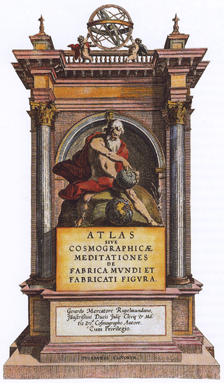
Gerardus Mercator was a Flemish geographer, cosmographer and cartographer. He is most renowned for creating the 1569 world map based on a new projection which represented sailing courses of constant bearing as straight lines—an innovation that is still employed in nautical charts.

Abraham Ortelius was a cartographer, geographer, and cosmographer from Antwerp in the Spanish Netherlands. He is recognized as the creator of the first modern atlas, the Theatrum Orbis Terrarum. Along with Gemma Frisius and Gerardus Mercator, Ortelius is generally considered one of the founders of the Netherlandish school of cartography and geography. He was a notable figure of this school in its golden age and an important geographer of Spain during the age of discovery. The publication of his atlas in 1570 is often considered as the official beginning of the Golden Age of Netherlandish cartography. He was the first person proposing that the continents were joined before drifting to their present positions.

Heinrich Cornelius Agrippa von Nettesheim was a German Renaissance polymath, physician, legal scholar, soldier, knight, theologian, and occult writer. Agrippa's Three Books of Occult Philosophy published in 1533 drew heavily upon Kabbalah, Hermeticism, and neo-Platonism. His book was widely influential among esotericists of the early modern period, and was condemned as heretical by the inquisitor of Cologne.
This article presents lists of the literary events and publications in 1578.
The year 1639 in science and technology involved some significant events.

Gemma Frisius was a Dutch physician, mathematician, cartographer, philosopher, and instrument maker. He created important globes, improved the mathematical instruments of his day and applied mathematics in new ways to surveying and navigation. Gemma's rings, an astronomical instrument, are named after him. Along with Gerardus Mercator and Abraham Ortelius, Frisius is often considered one of the founders of the Netherlandish school of cartography, and significantly helped lay the foundations for the school's golden age.
The year 1500 AD in science and technology included many events, some of which are listed here.
John Parr Snyder was an American cartographer most known for his work on map projections for the United States Geological Survey (USGS). Educated at Purdue and MIT as a chemical engineer, he had a lifetime interest in map projections as a hobby, but found the calculations tedious without the benefit of expensive calculators or computers. At a cartography conference in 1976, he learned of the need for a map projection that would suit the special needs of Landsat satellite imagery. He had recently been able to purchase a pocket calculator (TI-59) of his own and set to work creating what became known as the space-oblique mercator projection, which he provided to the USGS at no charge.

Edward Wright was an English mathematician and cartographer noted for his book Certaine Errors in Navigation, which for the first time explained the mathematical basis of the Mercator projection by building on the works of Pedro Nunes, and set out a reference table giving the linear scale multiplication factor as a function of latitude, calculated for each minute of arc up to a latitude of 75°. This was in fact a table of values of the integral of the secant function, and was the essential step needed to make practical both the making and the navigational use of Mercator charts.

CorneliusGemma was a Flemish physician, astronomer and astrologer, and the oldest son of cartographer and instrument-maker Gemma Frisius. He was a professor of medicine at the Catholic University of Leuven, and shared in his father's efforts to restore ancient Ptolemaic practice to astrology, drawing on the Tetrabiblos.
The year 1535 in science and technology included a number of events, some of which are listed here.
The year 1575 in science and technology included a number of events, some of which are listed here.
The year 1578 in science and technology included a number of events, some of which are listed here.
Bernardino Cirillo Franco, also called Bernardino Cirillo and Cyrilo Franco, was a Roman Catholic bishop of Loreto, Italy.

The Mercator world map of 1569 is titled Nova et Aucta Orbis Terrae Descriptio ad Usum Navigantium Emendate Accommodata. The title shows that Gerardus Mercator aimed to present contemporary knowledge of the geography of the world and at the same time 'correct' the chart to be more useful to sailors. This 'correction', whereby constant bearing sailing courses on the sphere are mapped to straight lines on the plane map, characterizes the Mercator projection. While the map's geography has been superseded by modern knowledge, its projection proved to be one of the most significant advances in the history of cartography, inspiring the 19th century map historian Adolf Nordenskiöld to write "The master of Rupelmonde stands unsurpassed in the history of cartography since the time of Ptolemy." The projection heralded a new era in the evolution of navigation maps and charts and it is still their basis.
Muzio or Mutio Oddi was an Italian mathematician and Gnomonist.

Gaspard van der Heyden was a goldsmith, engraver, master printer and builder of precision astronomical instruments including terrestrial and celestial globes from Leuven, Belgium. He was well known among the humanists in Leuven as well as among scientists and mathematicians.
References
- ↑ Crane, Nicholas (2003). Mercator: the man who mapped the planet. London: Phoenix. ISBN 0-7538-1692-X.
- ↑ "Cornelius Gemma: Cosmology, Medicine and Natural Philosophy in Renaissance Louvain conference proceedings". Archived from the original on 2011-10-06. Retrieved 2011-06-02.
- ↑ Marr, Alexander (2011). Between Raphael and Galileo: Mutio Oddi and the Mathematical Culture of Late Renaissance Italy. University of Chicago Press. ISBN 978-0-226-50628-9.