Related Research Articles
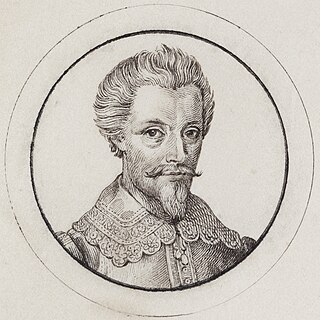
Abel Janszoon Tasman was a Dutch seafarer and explorer, best known for his voyages of 1642 and 1644 in the service of the Dutch East India Company (VOC). He was responsible for the naming of New Zealand, as well as being the namesake for Tasmania.

Tasmania is an island state of Australia. It is located 240 kilometres to the south of the Australian mainland, and is separated from it by the Bass Strait. The state encompasses the main island of Tasmania, the 26th-largest island in the world, and the surrounding 1000 islands. It is Australia's smallest and least populous state, with 573,479 residents as of June 2023. The state capital and largest city is Hobart, with around 40% of the population living in the Greater Hobart area. Tasmania is the most decentralised state in Australia, with the lowest proportion of its residents living within its capital city.
Van Diemen's Land was the colonial name of the island of Tasmania used by the British during the European exploration and colonisation of Australia in the 19th century. The island, inhabited by Aborigines, was first encountered by the Dutch ship captained by Abel Tasman in 1642, working under the sponsorship of Anthony van Diemen, the Governor-General of the Dutch East Indies. The British retained the name when they established a settlement in 1803 before it became a separate colony in 1825. Its penal colonies became notorious destinations for the transportation of convicts due to the harsh environment, isolation and reputation for being inescapable.
1642 (MDCXLII) was a common year starting on Wednesday of the Gregorian calendar and a common year starting on Saturday of the Julian calendar, the 1642nd year of the Common Era (CE) and Anno Domini (AD) designations, the 642nd year of the 2nd millennium, the 42nd year of the 17th century, and the 3rd year of the 1640s decade. As of the start of 1642, the Gregorian calendar was 10 days ahead of the Julian calendar, which remained in localized use until 1923.

The maritime European exploration of Australia consisted of several waves of European seafarers who sailed the edges of the Australian continent. Dutch navigators were the first Europeans known to have explored and mapped the Australian coastline. The first documented encounter was that of Dutch navigator Willem Janszoon, in 1606. Dutch seafarers also visited the west and north coasts of the continent, as did French explorers.

Zeehan is a town on the west coast of Tasmania, Australia 139 kilometres (86 mi) south-west of Burnie. It is part of the West Coast Council, along with the seaport Strahan and neighbouring mining towns of Rosebery and Queenstown.
Marion Bay is a rural / residential locality in the local government area (LGA) of Sorell in the South-east LGA region of Tasmania. The locality is about 27 kilometres (17 mi) east of the town of Sorell. The 2016 census recorded a population of 72 for the state suburb of Marion Bay. Marion Bay is also a large bay on the south-east coast of Tasmania. Its south-western shore is contained by the Marion Bay Important Bird Area.
The Maatsuyker Islands are a group of islands and rocks 5.5 kilometres (3.4 mi) off the south coast of Tasmania, Australia. Maatsuyker Island is the southernmost island of the group and of the Australian continental shelf. There are exposed rocks further south of Maatsuyker but they do not meet the definition of "islands". Macquarie Island, far to the south, is also Australian territory but it is an upthrust piece of ocean floor in the remote Southern Ocean and is in a geological sense completely separate from the continent.

Pedra Branca is a rock islet in the Southern Ocean, off the southern coast of Tasmania, Australia. The island is situated approximately 26 km (16 mi) south southeast of South East Cape and is contained within the Southwest National Park, part of the Tasmanian Wilderness World Heritage Site. An erosional remnant of the Tasmanian mainland, the island is approximately 270 m (890 ft) long, 100 m (330 ft) wide, with an elevation of 60 m (200 ft) above sea level. The island is estimated to have separated from the Tasmanian mainland at least 15,000 years ago.

Eddystone is a tower-shaped rock or small island, located in the Southern Ocean, off the southern coast of Tasmania, Australia. The island is situated approximately 27 km (17 mi) from the South East Cape on a bearing of 149° and is contained within the Southwest National Park, part of the Tasmanian Wilderness World Heritage Site. An erosional remnant of the Tasmanian mainland with an elevation of 30 m (98 ft) above sea level, the island is estimated to have separated from the Tasmanian mainland at least 15,000 years ago.

The Freycinet Peninsula is a large peninsula located on the eastern coast of Tasmania, Australia. The peninsula is located north of Schouten Island and is contained within the Freycinet National Park.

The Royal Hobart Regatta is a series of aquatic competitions and displays held annually in Hobart, Tasmania, Australia and is Tasmania's oldest sporting event. The regatta began in 1838.

Adventure Bay is the name of a locality, a township and a geographical feature on the eastern side of Bruny Island, Tasmania. At the 2021 census, Adventure Bay had a population of 218.
Mount Heemskirk is a mountain in Western Tasmania, west of the West Coast Range. It has an elevation of 751 metres (2,464 ft) above sea level. The closest town is Zeehan, about 14 kilometres (9 mi) away.
Salomon Sweers was a bookkeeper and a counsel for the Dutch East India Company. His younger brother was Admiral Isaac Sweers employed by the Admiralty of Amsterdam.
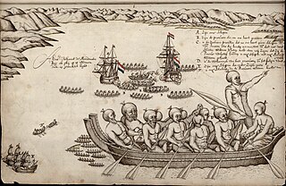
Isaack Gilsemans, was a Dutch merchant, officer of the Dutch East India Company and artist.

Mount ZeehanMOWNT-ZEE-ən is a mountain located in the Heemskirk Range on the West Coast of Tasmania, Australia. It has an elevation of 701 metres (2,300 ft) above sea level. The closest town is Zeehan, about 4.93 kilometres (3 mi) to the east.
Eddystone Point lies on the north-east coast of Tasmania, Australia at 40.994 S/148.349 E.
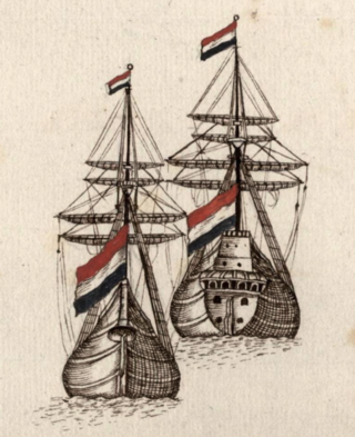
Heemskerck was the flagship of Abel Janszoon Tasman's exploratory voyage of 1642. She and her consort Zeehaen were the first European ships to explore the south coast of Australia, including Tasmania, cross the Tasman Sea, and reach New Zealand among other achievements.
References
- ↑ Marguin, Jean (1994). Histoire des instruments et machines à calculer: trois siècles de mécanique pensante 1642-1942. Paris: Hermann. p. 48. ISBN 978-2-7056-6166-3.
- ↑ "Isaac Gilsemans Original Chart of the Discovery of Tasmania, 24 Nov. to 5 Dec. 1642". National Library of Australia. Archived from the original on 29 June 2011. Retrieved 2011-05-19.