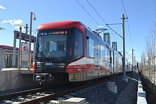
Calgary Transit is the public transit agency which is owned and operated by the city of Calgary, Alberta, Canada. In 2019, an estimated 106.5 million passengers boarded approximately 1,155 Calgary Transit vehicles. It operates light metro (LRT), urban tramway, bus rapid transit (BRT), para-transit, and regular bus services. In 2023, the system had a ridership of 144,385,200, or about 464,800 per weekday as of the second quarter of 2024.

CTrain is a light rail system in Calgary, Alberta, Canada. Much of the system functions as a high-capacity light metro, while in the downtown free-fare zone, trains run like a modern tram with a dedicated right-of-way. This subway-surface alignment is known as semi-metro.

Beltline is a region of central Calgary, Alberta, Canada. The area is located immediately to the south of Calgary's downtown, and is sometimes considered part of downtown. The neighbourhood is bounded on the south by 17th Avenue, on the west by 14th Street West and on the east by the Elbow River. Beltline is one of Calgary's most densely populated neighbourhoods as well as the most urban, featuring many apartments, condominiums and offices. It has the reputation of being one of Calgary's primary areas for eclectic night-life, restaurants and urban culture.
Crescent Heights is a neighbourhood located in Calgary, Alberta. It is located in the inner city, immediately north from Downtown. It is bounded to the north by the Trans-Canada Highway, on the east by Edmonton Trail, on the west by 4th Street NW, and to the south by Memorial Drive and the Bow River.
Ramsay is a residential neighbourhood in the southeast quadrant of Calgary, Alberta. It is an inner city community, located east of the Elbow River, Macleod Trail, Stampede Grounds and the Scotiabank Saddledome arena and south of Inglewood. To the southeast, it borders the Alyth-Bonny Brook industrial area. The eastern half of the community consists primarily of older homes and there is an industrial area in the most eastern corner of the community.
Country Hills is a residential neighbourhood in the northwest quadrant of Calgary, Alberta. It is bounded to the north by the Country Hills Boulevard, to the south by Beddington Trail, and to the east by Harvest Hills Boulevard. To the southwest, it is bordered by the Country Hills golf course which began construction in 1989 and opened in 1992. The clubhouse along with the fully developed course opened in 1999. the area is also bordered by the West Nose Creek. The neighborhood is often mistaken with Country Hills Estates which lies to the south between Country Hills Golf Club and Beddington Trail which was developed a decade earlier. The new community of Country Hills Village is located in the northeast of the neighbourhood. Country Hills is a generally calm and quiet area.
Tuxedo Park is a residential neighbourhood in the northeast and northwest quadrants of Calgary, Alberta. The inner city community is bounded to the north by 32 Avenue N, by Edmonton Trail to the east, the Trans-Canada Highway to the south and 2 Street NW to the west. The community is bisected by Centre Street from north to south.

The Capital Line is a light rail line on the Edmonton LRT system. The line operates from northeast Edmonton to the south. Operated by the Edmonton Transit Service, the line provides access to Downtown Edmonton and the University of Alberta. The Capital Line currently consists of fifteen stations, six of which are underground. Seven stations are shared with the Metro Line.

The Blue Line, also known as Route 202, is a light rail transit (LRT) line in Calgary, Alberta, Canada. Partnered with the Red Line, and future Green Line it makes up Calgary's CTrain network. Following its initial approval in 1976, the Red Line opened in 1981, with the first trains running on what is now the Blue Line in 1985.
The Green Line, also known as Route 203, is a proposed expansion of the light rail (LRT) network in Calgary, Alberta, planned to run between Calgary's north-central and southeastern boundaries, connecting with the Red Line and Blue Line in the city's downtown. The Green Line would be the largest public infrastructure project in Calgary's history and the first rail line in the city to operate low-floor trains if built. When completed, the full vision of the Green Line would be comprised of 29 stations spanning 46 kilometres (29 mi), bringing the total number of CTrain stations in Calgary to 74.

Urban rail transit in Canada encompasses a broad range of rail mass transit systems, including commuter rail, rapid transit, light rail, and streetcar systems.

MAX Purple, also known as Route 307 or the 17 Avenue SE BRT, is a bus rapid transit line in Calgary, Alberta. Part of Calgary Transit's MAX network, it largely travels east along 17 Avenue SE from downtown Calgary.
9 Avenue N station is a planned CTrain light rail station in Calgary, Alberta, part of the Green Line Stage 1, Phase 2. As of July 2024, a decision has not been made to build Phase 2.
Eau Claire station is a planned and approved CTrain light rail station in Calgary, Alberta, part of the Green Line. Construction is expected to begin in 2022 and complete in 2027 as the northern terminus of construction phase one. The station is named for and located in the high density urban community of Eau Claire, immediately north of downtown Calgary.
7 Avenue SW station is a planned and approved CTrain light rail station in Calgary, Alberta, part of the Green Line. Construction will begin in 2024 and complete in 2027 as part of construction stage one, phase one.
Centre Street S station is a planned and approved CTrain light rail station in Calgary, Alberta, part of the Green Line. Construction was slated to begin in 2024 and finish in 2030 as part of construction phase 1, segment 2A. However the station was deferred as part of a alignment change on July 30, 2024. The station is located in the Beltline, immediately south of downtown Calgary.
4 Street SE station is a planned and approved CTrain light rail station in Calgary, Alberta, part of the Green Line. Construction will begin in 2024 and complete in 2030 as part of construction stage one, segment 2A. The station is located in Beltline, immediately southeast of downtown Calgary near the confluence of the Bow River and Elbow River.
Ramsay/Inglewood station is a planned and approved CTrain light rail station in Calgary, Alberta, part of the Green Line. Construction will begin in 2022 and complete in 2027 as part of construction stage one, segment one. The station serves some of Calgary's oldest, most historic areas located in the urban inner-city communities of Ramsay and Inglewood.
26 Avenue SE station is a planned and approved CTrain light rail station in Calgary, Alberta, part of the Green Line. Construction will begin in 2022 and complete in 2027 as part of construction stage one, segment one. The station is located in Alyth/Bonnybrook/Manchester near Barlow Trail.
Highfield station is a planned and approved CTrain light rail station in Calgary, Alberta, part of the Green Line. Construction will begin in 2022 and complete in 2027 as part of construction stage one, segment one. The station is located in Calgary's oldest industrial area.


