1962 Makarska earthquakes

Last updated
1962 Makarska earthquakes
Croatia relief map.png
Bullseye1.png
UTC  time 
 1962-01-07 10:03:13
 1962-01-11 05:05:03
ISC  event 
  873992
  874017
USGS-ANSS  
  ComCat
  ComCat
Local date 
 January 07, 1962
 January 11, 1962
Local time 
 11:03:13 CET
 06:05:03 CET
Magnitude 
 A: 5.9 ML
6.2 Mw
 B: 6.2 Mw
Depth15.0 km
Epicenter 43°14′49″N17°01′08″E / 43.247°N 17.019°E / 43.247; 17.019 Coordinates: 43°14′49″N17°01′08″E / 43.247°N 17.019°E / 43.247; 17.019
Max. intensity VIII (Severe)
IX (Violent)
TsunamiYes
CasualtiesJanuary 7: 4 fatalities
January 11: 2 fatalities

The 1962 Makarska earthquakes occurred on January 7 to January 11 near the towns of Podgora and Makarska in Dalmatia, Croatia (at the time part of SFR Yugoslavia). The event is what is known as a doublet earthquake where there are two or more mainshocks occurring in a short span of time. The two earthquake measured 6.2 on the moment magnitude scale. The first tremor was assigned VIII (Severe), and the second event IX (Violent) on the Modified Mercalli intensity scale. [1] [2] [3] [4]

Contents

The earthquakes killed a total of 6 people, and caused damage to vulnerable structures. A tsunami may have been triggered by the quakes according to nearby tide gauges. [5]

Geological location

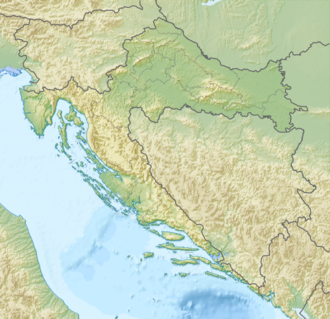
Dalmatia, the southern part of Croatia, is located in a tectonic thrust zone in the Adriatic basin with the African and Eurasian plates colliding within it. However, some believe that the entirety of the Adriatic lies in a separate micro-plate known as the Apulia-Adriatic micro-plate that moves northeast into the Swiss Alps at a rate of about 1-2 millimeters in the north and 4-5 millimeters in the south. In the west, it's situated nearby the Dinaric Alps which runs through the Balkan peninsula all the way to Albania in the south. It also neighbors the Italian west coast which is also a hot zone for earthquakes and where you can find the Apennine Mountains, also known as the spine of the Italian peninsula. [6]

Due to this, the entirety of the Croatian west coast is exposed to seismic activity, which includes earthquakes with magnitudes above 6. The most notable event is the 1667 Dubrovnik earthquake that occurred near the town of Dubrovnik reaching intensities as high as IX resulting in the deaths of many. [6]

Earthquakes

January 7

The first earthquake measured a preliminary 5.8 on the body wave magnitude scale and was initially believed to be a foreshock to the second earthquake; however, this idea was later ruled out. Its epicenter was between the town of Makarska in the mainland and the island of Hvar southwest. [3] [7]

January 11

The second earthquake was much stronger with magnitudes of 6.1–6.2. It was deemed the mainshock of the two. Fortunately it occurred further from population centres such as Makarska and Podgora. Despite this, many more buildings were damaged and local accounts said the residents were more terrified. [4]

Further shocks rocked the area for 15 days, damaging local infrastructure and further levelling buildings on the islands near the epicenter, especially on Hvar. [7]

Tsunami

There has been some speculation that the strength of the earthquake was enough to generate a tsunami a high as one meter in height. Further studies revealed that gauges recorded a small change in wave height right after the earthquake struck. However, no tsunami was noticed by the locals and no damage was caused by the said tsunami. [5]

Damage and casualties

According to local information, 3,256 buildings and houses completely collapsed, 108 of them being schools, and about 500 others were seriously damaged to the point of being demolished soon afterwards. Makarska suffered the full brunt having 193 buildings collapsed from the second earthquake, followed by Podgora with 111 and Drašnice having 100 buildings collapsed. About 400 other buildings were spared by only suffering cracks in the walls and only needed reparations. [8] [7]

The first earthquake killed four people, most likely from falling debris and collapsed walls. The second quake, which was much better documented, killed two people. One of them was Emil Marinović, 20 years of age when his house fell onto him in Podgora. Another person from Drašnice, 62-year-old Jure Prlac was killed after he was hit in a local landslide. [7]

In response, the Yugoslav army sent 200 tents to accommodate the 3,500 people most affected, however the majority decided to flee the area and seek refuge in other areas. In the years that followed the area still greatly suffered from the effects of the earthquakes and more people left for other areas. At one point there were only 200 residents left in Makarska. [7]

Impact

The local populace in the afflicted areas was forced to evacuate due to the heavy damage and the devastating consequences that were caused by the earthquakes. The effects of this event can still be observed, especially in Makarska and nearby Biokovsko Selo where the village is still very much silent. The elderly residents remember the event in shocking detail. [9] The earthquake is also well known in seismic studies in Croatia. Ivan Hrstić, a local scientist, discussed the earthquake during a scientific conference in 2012. [7]

See also

Related Research Articles

<span class="mw-page-title-main">Makarska</span> City in Split-Dalmatia, Croatia

Makarska is a town on the Adriatic coastline of Croatia, about 60 km (37 mi) southeast of Split and 140 km (87 mi) northwest of Dubrovnik, in the Split-Dalmatia County.

The 1918 Shantou earthquake occurred in Shantou, Guangdong, Republic of China. Serious damage and high casualty numbers were reported in Guangdong and the surrounding provinces. It also caused some damage in what was then British Hong Kong.

The 1202 Syria earthquake struck at about dawn on 20 May 1202 with an epicenter in southwestern Syria. The earthquake is estimated to have killed around 30,000 people. It was felt over a very wide area, from Sicily to Mesopotamia and Anatolia to upper Egypt, mostly affecting the Ayyubid Sultanate and the Kingdom of Jerusalem. The cities of Tyre, Acre and Nablus were heavily damaged. A magnitude of Ms 7.6 has been estimated with damage up to XI on the Mercalli intensity scale.

The 1730 Valparaíso earthquake occurred at 04:45 local time on July 8. It had an estimated magnitude of 9.1–9.3 and triggered a major tsunami with an estimated magnitude of Mt  8.75, that inundated the lower parts of Valparaíso. The earthquake caused severe damage from La Serena to Chillan, while the tsunami affected more than 1,000 km (620 mi) of Chile's coastline.

<span class="mw-page-title-main">1839 Ava earthquake</span> Earthquake in British India

The 1839 Ava earthquake, also known as the Amarapura earthquake or Inwa earthquake was a disastrous seismic event that struck central Burma on the morning of March 23. This earthquake with a moment magnitude as high as 8.3, was one of the biggest in the country since 1762. Shaking reached XI (Extreme) on the Modified Mercalli intensity scale, and was felt in Rangoon and Bhamo.

On January 1, 1996, at 4:05 p.m. Central Indonesia Time, an earthquake with an epicenter in the Makassar Strait struck north of Minahasa on the island of Sulawesi, Indonesia. The earthquake measured 7.9 on the moment magnitude scale and was centered off Tolitoli Regency in Central Sulawesi, or 25 km from the Tonggolobibi village. A tsunami of 2–4 m (6.6–13.1 ft) was triggered by this earthquake as a result. At least 350 buildings were badly damaged, nine people died and 63 people were injured.

The 1674 Ambon earthquake occurred on February 17 between 19:30 and 20:00 local time in the Maluku Islands. The resulting tsunami reached heights of up to 100 metres (330 ft) on Ambon Island killing over 2,000 individuals. It was the first detailed documentation of a tsunami in Indonesia and the largest ever recorded in the country. The exact fault which produced the earthquake has never been determined, but geologists postulate either a local fault, or a larger thrust fault offshore. The extreme tsunami was likely the result of a submarine landslide.

The Nemuro-Oki earthquake in scientific literature, occurred on June 17 at 12:55 local time. It struck with an epicenter just off the Nemuro Peninsula in northern Hokkaidō, Japan. It measured 7.8–7.9 on the moment magnitude scale (Mw ), 8.1 on the tsunami magnitude scale (Mt ) and 7.4 on the Japan Meteorological Agency magnitude scale (MJMA ).

<span class="mw-page-title-main">2021 Chignik earthquake</span> 7th largest earthquake in the US

An earthquake occurred off the coast of the Alaska Peninsula on July 28, 2021, at 10:15 p.m. local time. The large megathrust earthquake had a moment magnitude of 8.2 according to the United States Geological Survey (USGS). A tsunami warning was issued by the National Oceanic and Atmospheric Administration (NOAA) but later cancelled. The mainshock was followed by a number of aftershocks, including three that were of magnitude 5.9, 6.1 and 6.9 respectively.

The 1979 Petatlán earthquake, also known as the IBERO earthquake occurred on March 14 at 05:07 local time in the Mexican state of Guerrero. The earthquake had a surface wave magnitude of Ms  7.6 or moment magnitude of Mw  7.4 and maximum Modified Mercalli intensity of VIII (Severe). The epicenter, onshore, was located 12 km south southeast of Vallecitos de Zaragoza.

During April 1819, the area around Copiapó in northern Chile was struck by a sequence of earthquakes over a period of several days. The largest of these earthquakes occurred on 11 April at about 15:00 local time, with an estimated magnitude of Mw 8.5. The other two events, on 3 April between 08:00 and 09:00 local time and on 4 April at 16:00 local time, are interpreted as foreshocks to the mainshock on 11 April. The mainshock triggered a tsunami that affected 800 km of coastline and was also recorded at Hawaii. The city of Copiapó was devastated.

The Fars region of Iran was struck by a major earthquake on either 22 April or 5 May 1853. The city of Shiraz and the surrounding area were severely affected, with almost all buildings destroyed. At least 9,000 people were killed, with some estimates reaching 13,000.

The 1604 Quanzhou earthquake was an extremely large seismic event that occurred in the Taiwan Strait, off the coast of Fujian Province, near Quanzhou during the Ming dynasty. According to modern-day calculations, the earthquake had a moment magnitude of 8.1 Mw. It is unknown how many casualties resulted from the quake, but major damage was reported.

The 1872 Amik (Antioch) earthquake occurred on April 3 with an epicenter the Amik Valley in the Ottoman Empire. Earthquake catalogs place the surface-wave magnitude at Ms  7.2 and MSK 64 rating at XI (Catastrophic). Turkey and Syria were devastated by this earthquake, and the region lost at least 1,800 residents.

<span class="mw-page-title-main">1898 Trilj earthquake</span> Earthquake in modern Croatia

The 1898 Trilj earthquake occurred on Saturday, July 2, 1898, near the town of Trilj in the then-Kingdom of Dalmatia, Austria-Hungary, with the moment magnitude of 6.7. The estimated intensity at the epicenter was VIII–IX on the Medvedev–Sponheuer–Karnik scale. It is one of the strongest earthquakes in Croatian history. This is also the first time an earthquake in Croatia were recorded by seismographs at Italian, German, British, Ukrainian, Russian and Slovenian seismic stations.

<span class="mw-page-title-main">1996 Ston–Slano earthquake</span> Strong earthquake in Dalmatia, Croatia

On 5 September 1996 at 22:44 local time, southern Dalmatia, Croatia, was hit by a strong earthquake of moment magnitude 6.0. The epicentre was near the coastline of the Adriatic Sea, close to the village of Slano, roughly 15 kilometres (9.3 mi) northwest of Dubrovnik. The worst damage was of intensity VIII on the Medvedev–Sponheuer–Karnik scale, occurring in the epicentral area, but also another 25 km (16 mi) northwest, at the isthmus of the Pelješac peninsula, around the old town of Ston.

The 1955 Lanao earthquake struck Lanao del Sur on April 1 at 02:17 local time. The earthquake measuring 7.4 on the moment magnitude scale and assigned a maximum intensity of VIII (Severe) on the Modified Mercalli intensity scale was one of the largest to hit Mindanao. It caused immense damage around Lake Lanao and the southern reaches of the Visayan islands. It killed at least 465 individuals and injured a further 898.

<span class="mw-page-title-main">1867 Java earthquake</span> Earthquake in the Dutch East Indies (present-day Indonesia)

The 1867 Central Java earthquake occurred on June 10 at between 04:20 and 04:30 local time. It struck off the southern coast of the Indonesian island with an estimated moment magnitude of 7.8 (Mw ). Widespread devastation occurred in Central Java, where as many as 700 people were killed. The intermediate-depth intraslab earthquake did not cause a tsunami.

The 1755 Meknes earthquake affected Morocco on 27 November 1755. The earthquake had a moment magnitude (Mw ) estimated at between 6.5 and 7.0. It devastated the cities of Fes and Meknes—killing at least 15,000 people in both cities.

References

  1. "M 6.2 - 4 km SW of Tu?epi, Croatia". earthquake.usgs.gov. Archived from the original on 2021-01-28. Retrieved 2021-11-28.
  2. "M 6.2 - Croatia-Bosnia and Herzegovina border region". earthquake.usgs.gov. Archived from the original on 2021-01-27. Retrieved 2021-11-28.
  3. 1 2 "NCEI Global Historical Hazard Database". www.ngdc.noaa.gov. Retrieved 2021-11-28.
  4. 1 2 "NCEI Global Historical Hazard Database". www.ngdc.noaa.gov. Retrieved 2021-11-28.
  5. 1 2 Herak, Marijan; Orlić, Mirko; Kunovec-Varga, Mario (2001-01-01). "Did the Makarska earthquake of 1962 generate a tsunami in the central Adriatic archipelago?". Journal of Geodynamics. 31 (1): 71–86. doi:10.1016/S0264-3707(00)00018-1. ISSN   0264-3707.
  6. 1 2 "The Adriatic on a Plate". Go Hvar. 2012-11-26. Retrieved 2021-11-28.
  7. 1 2 3 4 5 6 "NA DANAŠNJI DAN 1962. Udarom od 5,9 po Richteru započelo 15 dana straha, serija potresa ubila dvoje ljudi i ispraznila Makarsku i primorje". Makarsko Primorje (in Croatian). Retrieved 2021-11-28.
  8. "Slobodna Dalmacija - Makarsko područje je 1962. pogodio strašan potres. Aktivirale su se lavine stijena, srušilo se 108 škola, 3256 kuća... Tito je došao tješiti Makarane". slobodnadalmacija.hr (in Croatian). 2021-01-07. Retrieved 2021-11-28.
  9. "Dan kad se Biokovo srušilo na Makarsku: 'Taj potres ću osjećati u krvi dok sam živ'". www.vecernji.hr (in Croatian). Retrieved 2021-11-28.