1962 Buin Zahra earthquake

Last updated

1962 Buin Zahra earthquake
Iran relief location map.jpg
Bullseye1.png
Green pog.svg
Tehran
UTC  time1962-09-01 19:20:41
ISC  event 17292570
USGS-ANSS ComCat
Local dateSeptember 1, 1962 (1962-09-01)
Local time22:50:41 IRST
Magnitude7.1 ML
Depth10 km (6.2 mi) [1]
Epicenter 35°38′N49°52′E / 35.63°N 49.87°E / 35.63; 49.87
FaultIpak Fault
Areas affected Iran
Max. intensity IX (Violent) [2]
Casualtiesat least 12,225 dead, 2,776 injured

The 1962 Buin Zahra earthquake occurred on September 1 in the area of Buin Zahra, Qazvin Province, Iran. The shock had a Richter magnitude of 7.1 and resulted in 12,225 fatalities. [3] Qazvin Province lies in an area of Iran that experiences large earthquakes. The 1962 event originated on one of many faults in the area, called the Ipak Fault. The fault is believed to have been reactivated multiple times.

Contents

Geology

Iran is a seismically active zone, lying between the converging Eurasian and Arabian Plates. Because it has both strike-slip and reverse faults, earthquakes often proceed so that if one fault is overwhelmed by movement, the movement will branch off to another fault, creating a separate earthquake. [4]

Buin Zahra County lies within a zone of active thrust faults, complemented by folds, that extends south from the Alborz mountains. [5] Despite the presence of faults, Qazvin Province does not regularly experience earthquakes. However, the space between earthquakes allows pressure to build up on faults, increasing the power – and magnitude – of the earthquakes. [6]

Specifically, the 1962 event originated on the Ipak Fault of northern Iran, along which it and aftershocks cut roughly 64 miles (103 km) of west-northwest trending surface faulting. [7] A feature that extends for 64 miles (103 km) with its connected, smaller faults, the fault runs from the village of Ipak to Takhrijin. Iranian geologist Manuel Berberian's research indicates that the Ipak Fault is at least as old as the Carboniferous period, and has probably been reactivated several times since its formation. On the fault's south side, Carboniferous material is visible; this debris is not evident on the north side, which suggests that the fault was acting as a "dividing fault" while the area around it underwent sedimentation. Berberian could find no trace of Upper Guadalopian or Julfian sediments north of the fault. Another possible reason for this anomaly could be erosion; uplift could have exposed the northern portion of the fault but not the south. [8]

Damage and casualties

"Actie Herbouw Perzisch Dorp Dousadj"
("action rebuilding of the Persian village Dousadj") organized by the Dutch people Aktie Herbouw Perzisch Dorp Dousadj op de Dam begonnen Wethouder Tabak plakt he, Bestanddeelnr 915-2670.jpg
"Actie Herbouw Perzisch Dorp Dousadj"
("action rebuilding of the Persian village Dousadj") organized by the Dutch people

12,225 fatalities resulted from the earthquake. An additional 2,776 people were injured, along with 21,310 houses either destroyed or too damaged to repair. 35 percent of domestic livestock was also killed, and several landslides and rock falls followed the rupture. [7] 21,000 houses were destroyed, mainly because they were made up of mud and brick. Over 7,500 were buried in 31 individual villages, followed by reports from 60 additional villages. In these villages, however, 26,618 survived. One hospital in Tehran was "packed" with over 2,500 victims. [9]

Slight damage was experienced in Tehran, the nation's capital. Cities as far away as Tabriz, Esfahan and Yazd reported the tremor. Sandblows also formed along the rupture zone. The earthquake was also declared the largest rupture in the region since approximately 1630. Multiple reports came from the Rudak area of earthquake lights. [10]

Relief efforts

Gholamreza Takhti and students organized relief efforts. Pahlavan takhti meel.jpg
Gholamreza Takhti and students organized relief efforts.

Rescue operators suggested that an aerial and on-land search should be initiated to help victims. Officials expressed worries that people had gone for over a week with no aid. [11] Iranian wrestling star Gholamreza Takhti gathered blankets, money, and food for victims and transported them by trucks. [12] Because government response was slow, students at the University of Tehran took matters into their own hands. After gathering supplies, the students organized an effort to dispatch medical students and interns to the site of the disaster. Their teams were however blocked by Iranian National Guard members who had been commanded to kill any civilians who tried to help victims; writer Marcello di Cintio cites in Poets and Pahlevans: A Journey into the Heart of Iran that the "Shah was not about to let a crowd of students draw attention to his inept relief efforts". [13]

Future threats

Since roughly 90 percent of Iran lies within seismically active land, the threat from earthquakes is high. In 2002, an earthquake in Buin Zahra killed more than 250 people and left roughly 25,000 without homes. [14]

In addition to its geological threat, Iran has poor earthquake engineering. In a 2004 report by ScienceDaily, it was listed as "the worst offender" globally for poor earthquake engineering. [15] Professor Roger Bilham of the University of Colorado at Boulder, a geophysicist who specializes in earthquake-related deformation and hazards, blames construction practices for the fact that since the start of the 20th century, 1 in 3,000 Iranians has died in an earthquake-related incident. Bilham adds, "Most of Iran needs rebuilding. If the population of Iran had a choice between spending oil revenues on munitions or houses that won't kill them, I suspect they would choose a safe home. It's all a matter of earthquake education." [15] A Common Country Assessment by The United Nations for Iran has similar results, stating that, "While adequate building regulations exist for large cities, it is generally believed that they are not rigorously adhered to... most of those who have suffered in recent major earthquakes have lived in small towns and villages. Earthquake-proof construction is very rare in those areas and adequate building regulations are not yet in place". [16]

See also

Bibliography

Related Research Articles

<span class="mw-page-title-main">1978 Tabas earthquake</span> 7.4 Mw earthquake in east-central Iran

The 1978 Tabas earthquake occurred on September 16 at 19:05:55 local time in central Iran. The shock measured 7.4 on the moment magnitude scale and had a maximum Mercalli intensity of IX+ (Violent). The death toll was in the range of 15,000–25,000, with severe damage occurring in the town of Tabas.

<span class="mw-page-title-main">Gholamreza Takhti</span> Iranian wrestler (1930–1968)

Gholamreza Takhti was an Iranian freestyle wrestler and varzesh-e bastani practitioner. He was a gold medalist at the 1956 Summer Olympics, 1958 Asian Games, 1959 World Championships, and 1961 World Championships, as well as a three-time Pahlevan of Iran. Popularly nicknamed Jahân Pahlevân because of his chivalrous behavior and sportsmanship, he was the most popular athlete of Iran in the 20th century, although dozens of Iranian athletes have won more international medals than he did. Takhti is still a hero to many Iranians. He is listed in the UWW Hall of Fame.

An earthquake affected several villages in the Kerman province of Iran on February 22, 2005, at 05:55:23 local time. The shock measured 6.4 on the moment magnitude scale and had a maximum Mercalli intensity of VIII (Severe). Zarand is located 740 km southeast of Tehran. The maximum recorded peak ground acceleration was 0.51 g at Shirinrud dam. The United States' National Earthquake Information Center and the Belgian' Centre for Research on the Epidemiology of Disasters both show that 612 died and 1,411 were injured in the event.

<span class="mw-page-title-main">2005 Qeshm earthquake</span> Earthquake in Iran

An earthquake occurred on November 27, 2005, at 13:52 IRST on the sparsely populated Qeshm Island off Southern Iran, killing 13 people and devastating 13 villages. It was Iran's second major earthquake of 2005, following the one at Zarand in February. The epicenter was about 1,500 kilometers (930 mi) south of Tehran, close to Iran's southern borders. Initial measurements showed that the earthquake registered about 6.0 on the moment magnitude scale, although that was reduced to 5.8 after further analysis. More than 400 minor aftershocks followed the main quake, 36 of which were greater than magnitude 2.5. The earthquake occurred in a remote area during the middle of the day, limiting the number of fatalities. Iranian relief efforts were effective and largely adequate, leading the country to decline offers of support from other nations and UNICEF.

<span class="mw-page-title-main">Buin Zahra County</span> County in Qazvin province, Iran

Buin Zahra County is in Qazvin province, Iran. Its capital is the city of Buin Zahra.

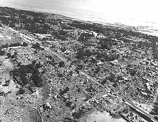
The Dasht-e Bayaz and Ferdows earthquakes occurred in Dashte Bayaz, Kakhk and Ferdows, Iran in late August and early September 1968. The mainshock measured 7.4 on the moment magnitude scale and had a maximum perceived intensity of X (Extreme) on the Mercalli intensity scale. Damage was heavy in the affected areas with thousands of lives lost in the first event and many hundreds more in the second strong event.

The 2002 Bou'in-Zahra earthquake occurred on 22 June 2002. The epicenter was near the city of Bou'in-Zahra in Qazvin Province, a region of northwestern Iran which is crossed by several major faults that is known for destructive earthquakes. The shock measured 6.5 on the Mwc scale, had a maximum Mercalli intensity of VIII (Severe), and was followed by more than 20 aftershocks. At least 230 people were killed and 1,500 more were injured.

Avaj is a city in the Central District of Avaj County, Qazvin province, Iran, serving as capital of both the county and the district Its people speak Azerbaijani.

The Qayen earthquake, also known as the Ardekul or Qaen earthquake, struck northern Iran's Khorasan Province in the vicinity of Qaen on May 10, 1997 at 07:57 UTC. The largest in the area since 1990, the earthquake registered 7.3 on the moment magnitude scale and was centered approximately 270 kilometers (170 mi) south of Mashhad on the village of Ardekul. The third earthquake that year to cause severe damage, it devastated the Birjand–Qayen region, killing 1,567 and injuring more than 2,300. The earthquake—which left 50,000 homeless and damaged or destroyed over 15,000 homes—was described as the deadliest of 1997 by the United States Geological Survey. Some 155 aftershocks caused further destruction and drove away survivors. The earthquake was later discovered to have been caused by a rupture along a fault that runs underneath the Iran–Afghanistan border.

The 1909 Borujerd earthquake also known as Silakhor earthquake occurred in Silakhor plain, Persia on January 23. Around 8,000 fatalities were caused directly from the magnitude 7.3 earthquake. An indefinite number of aftershocks continued for six months after the main shock. The section on this fault ruptured was the same as the main rupture zone of the 2006 Borujerd earthquake.

The 1930 Salmas earthquake occurred on May 7 at 01:34:26 IRST in West Azerbaijan Province, Iran. The earthquake, which was among Iran's largest, measured 7.1 on the moment magnitude scale and had a maximum Mercalli intensity of IX (Violent). A damaging foreshock occurred fifteen hours prior to the main event and served as a warning to the people that felt it strongly. Reports from seismologists and seismological organizations indicate that up to 3,000 fatalities may have occurred in northwest Iran and southeast Turkey.

The 1905 Kangra earthquake occurred in the Kangra Valley and the Kangra region of the Punjab Province in India on 4 April 1905. The earthquake measured 7.8 on the surface wave magnitude scale and killed more than 20,000 people. Apart from this, most buildings in the towns of Kangra, Mcleodganj and Dharamshala were destroyed.

Duzduzan ; also Romanized as Dūzdūzān, is a city in Mehraban District of Sarab County, East Azerbaijan province, Iran.

The 1979 Ghaenat earthquakes were a series of large earthquakes in Qaen County, Khorasan Province, northeast Iran, near the Afghanistan border. The first mainshock, known as the Korizan earthquake with a surface wave magnitude (Ms ) of 6.6 and moment magnitude (Mw ) of 6.8, struck on November 14, while the Ms  7.1 or Mw  7.2 Koli-Boniabad earthquake struck on November 27. The two mainshocks were assigned a maximum Modified Mercalli intensity of VIII (Severe) and X (Extreme), respectively. The earthquakes caused extensive damage throughout northeastern Iran, killing an estimated 297 to 440 people and left at least 279 injured.

The 1997 Bojnurd earthquake occurred on 4 February at 14:07 IRST in Iran. The epicenter of the Mw 6.5 earthquake was in the Kopet Dag mountains of North Khorasan, near the Iran–Turkmenistan border, about 579 km (360 mi) northeast of Tehran. The earthquake is characterized by shallow strike-slip faulting in a zone of active faults. Seismic activity is present as the Kopet Dag is actively accommodating tectonics through faulting. The earthquake left 88 dead, 1,948 injured, and affected 173 villages, including four which were destroyed. Damage also occurred in Shirvan and Bojnord counties. The total cost of damage was estimated to be over US$ 30 million.

<span class="mw-page-title-main">1641 Tabriz earthquake</span> Earthquake centered in northwestern Iran

The 1641 Tabriz earthquake occurred on the night of February 5 in present-day East Azerbaijan province, Iran. The earthquake had an estimated surface-wave magnitude of 6.8 and an epicenter between Lake Urmia and the city of Tabriz. It was one of the most destructive earthquakes in the region, resulting in the loss of up to 30,000 lives.

The 1977 Bob–Tangol earthquake struck Kerman province of Iran on December 20, 1977 at 03:04 Iran Standard Time. The earthquake measured Mw 5.9 and struck at a depth of 22.7 km (14.1 mi). A maximum Modified Mercalli intensity of VII was evaluated based on damage. It had a strike-slip focal mechanism, which was unusual as the source structure was a thrust fault. It was part of a sequence of strong earthquakes along the 400 km (250 mi) Kuh Banan Fault. Between 584 and 665 people perished while a further 500–1,000 were injured; thousands were also made homeless. Casualties from the earthquake was considered moderate due to the sparsely populated area it affected. Preceded by foreshocks the month before, many residents became wary of a larger earthquake and took refuge outside their homes, contributing to the moderate death toll. However, there were none immediately before the mainshock so many were still in their homes when it struck. Aftershocks were felt for several months, some causing additional damage.

The 1957 Sangchal earthquake struck northern Iran's Mazandaran province on 2 July 1957. It had a moment magnitude of 6.6 or 7.1 (Mw ), focal depth of 15 km (9.3 mi), and maximum Modified Mercalli intensity of IX (Violent). It devastated many communities in the Alborz Mountains and caused an estimated 1,500 fatalities. Damage was estimated at US$25 million.

The 1957 Farsinaj earthquake struck Hamadan, Iran on 13 December at 05:15 local time. The moment magnitude 6.5 earthquake destroyed 211 villages, killed approximately 1,130 people, and left another 900 injured.

References

  1. Mostafazadeh & Mokhtari 2003, p. 2.
  2. Berberian, M. (2014), Earthquakes and Coseismic Surface Faulting on the Iranian Plateau, Developments in Earth Surface Processes (1st ed.), Elsevier, p. 603, ISBN   978-0444632920
  3. "Historic Worldwide Earthquakes". United States Geological Survey. January 29, 2009. Archived from the original on February 21, 2009. Retrieved February 21, 2009.
  4. Berberian, Manuel, and Yeats, Robert S, pp. 120–139.[ citation needed ]
  5. Walker, R. T.; Bergman, E; Jackson, J; Ghorashi, M; Talebain, M. (2005). "The 2002 June 22 Changureh (Avaj) earthquake in Qazvin province, northwest Iran: epicentral relocation, source parameters, surface deformation and geomorphology". Geophysical Journal International . 160 (2): 707–720. Bibcode:2005GeoJI.160..707W. doi:10.1111/j.1365-246X.2005.02516.x.
  6. "Help too late, say quake survivors". CNN. Time Warner. June 24, 2002. Archived from the original on April 24, 2009. Retrieved March 20, 2010.
  7. 1 2 Ambraseys 1963, pp. 705–740.
  8. Berberian 1976, p. 420.
  9. "Quake Victims Exceed Fears". Ellensburg Daily Record. September 6, 1962. Retrieved February 22, 2009.[ permanent dead link ]
  10. "Earthquakes with 1,000 or More Deaths since 1900". United States Geological Survey. January 29, 2009. Archived from the original on May 15, 2009. Retrieved February 22, 2009.
  11. Jay Walz (September 9, 1962). "Wide Search Is Pressed in Iran For Additional Quake Victims; Rescuers Fear Some in Remote Villages Have Suffered a Week With No Aid --Relief Operations Stepped Up U.S. Copters Join Search Families Won't Separate". New York Times. Retrieved February 22, 2009.
  12. "British Museum Opens New Exhibition, Takhti: A Modern Iranian Hero". ArtDaily. 2007. Retrieved February 21, 2009.
  13. di Cintio, Marcello (2007). Poets and Pahlevans: A Journey into the Heart of Iran. Random House Digital, Inc. p. 272.
  14. "Preliminary Earthquake Reconnaissance Report on the June 22, 2002 Changureh (Avaj), Iran Earthquake". International Institute of Earthquake Engineering and Seismology. July 19, 2002. Archived from the original on March 25, 2010. Retrieved February 19, 2010.
  15. 1 2 "Contractor Ignorance Kills Earthquake Victims In Sesmic (sic) Zones, Says U. Of Colorado Professor". ScienceDaily . ScienceDaily LLC. December 28, 2004. Retrieved October 11, 2009.
  16. "United Nations Common Country Assessment for the Islamic Republic of Iran" (PDF). United Nations. Archived from the original (PDF) on July 19, 2011. Retrieved November 23, 2009.