1971 Solomon Islands earthquakes

Last updated
1971 Solomon Islands earthquakes
Papua New Guinea relief location map.jpg
Red pog.svg
July 14
Red pog.svg
July 26
UTC  time Doublet earthquake:    
 A: 1971-07-14 06:11:29
 B: 1971-07-26 01:23:22
ISC  event 
 A: 782181
 B: 782684
USGS-ANSS  
 A: ComCat
 B: ComCat
Local time 
 A: 16:11:29
 B: 11:23:22
Magnitude 
 A: mb 6.0, Ms 7.8 (ISC)
    Mw8.0 (ANSS)
 B: mb 6.6, Ms 7.7 (ISC)
    Mw8.1 (ANSS)
DepthA: 45 km (28 mi)
B: 37 km (23 mi) [1]
Max. intensityA: IX (Violent)
B: VI (Strong) [2]
Casualties2 dead, 5 injured [2]

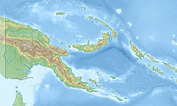
The 1971 Solomon Islands earthquakes occurred in the northern part of the Solomon Islands, within Papua New Guinea as a doublet earthquake. The first large shock occurred on July 14 at 06:11 UTC with a magnitude of Mw 8.0. The second large event occurred on July 26 at 01:23 UTC with a magnitude of Mw 8.1. The initial event on July 14 caused a tsunami, which was observed in Rabaul. [3] The earthquake of July 26 triggered a tsunami with a 3.4 m (11 ft) runup in New Britain. [4]

Contents

Shallow, large thrust earthquakes in the Solomon Islands tend to occur in multiplets. Examples of such earthquakes include the doublets occurred in 1971, 1974, and 1975. The 1971 doublet occurred at the junction of two trenches. The July 14 earthquake is located in the northwestern Solomon Islands Trench, while the July 26 earthquake ruptured the northeastern New Britain Trench. The July 14 earthquake and the July 26 earthquake were caused by the subduction of the Solomon Sea Plate beneath the Pacific Plate and the Bismark Sea Plate, respectively. [5] The 1971 sequence had the largest earthquake in 50 years in this region as it occurred. [6]
See also

Related Research Articles

<span class="mw-page-title-main">1946 Aleutian Islands earthquake</span> Earthquake near the Aleutian Islands, Alaska

The 1946 Aleutian Islands earthquake occurred near the Aleutian Islands, Alaska on April 1, 1946. The shock had a moment magnitude (Mw ) of 8.6, a tsunami magnitude Mt  of 9.3, and a surface-wave magnitude (Ms ) of only 7.4, and a maximum Mercalli intensity of VI (Strong). It resulted in 165–173 casualties and over $26 million in damage. The seafloor along the fault was elevated, triggering a Pacific-wide tsunami with multiple destructive waves at heights ranging from 45–138 ft (14–42 m). The tsunami obliterated the Scotch Cap Lighthouse on Unimak Island, Alaska among others, and killed all five lighthouse keepers. Despite the destruction to the Aleutian Island Unimak, the tsunami had almost an imperceptible effect on the Alaskan mainland.

<span class="mw-page-title-main">1946 Nankai earthquake</span>

The 1946 Nankai earthquake was a great earthquake in Nankaidō, Japan. It occurred on December 21, 1946, at 04:19 JST. The earthquake measured between 8.1 and 8.4 on the moment magnitude scale, and was felt from Northern Honshū to Kyūshū. It occurred almost two years after the 1944 Tōnankai earthquake, which ruptured the adjacent part of the Nankai megathrust.

The 2000 New Ireland earthquakes occurred off the coast of New Ireland Province, Papua New Guinea on November 16 and 17.

<span class="mw-page-title-main">1896 Sanriku earthquake</span> Japanese tsunami earthquake

The 1896 Sanriku earthquake was one of the most destructive seismic events in Japanese history. The 8.5 magnitude earthquake occurred at 19:32 on June 15, 1896, approximately 166 kilometres (103 mi) off the coast of Iwate Prefecture, Honshu. It resulted in two tsunami waves which destroyed about 9,000 homes and caused at least 22,000 deaths. The waves reached a then-record height of 38.2 metres (125 ft); this would remain the highest on record until waves from the 2011 Tōhoku earthquake exceeded that height by more than 2 metres.

The 1965 Rat Islands earthquake occurred at 05:01 UTC, on 4 February. It had a magnitude of 8.7 and triggered a tsunami of over 10 m on Shemya Island, but caused very little damage.

<span class="mw-page-title-main">1978 Miyagi earthquake</span>

The 1978 Miyagi earthquake occurred at 17:14 local time on 12 June. The epicentre was offshore of Miyagi Prefecture, Japan. It had a surface wave magnitude of 7.7, JMA magnitude 7.4, and triggered a small tsunami. The earthquake reached a maximum intensity of Shindo 5 in Sendai and caused 28 deaths and 1,325 injuries.

The 1996 Biak earthquake, or the Irian Jaya earthquake, occurred on 17 February at 14:59:30 local time near Biak Island, Indonesia. The earthquake, which occurred on the New Guinea Trench, had a moment magnitude of 8.2 and a maximum Mercalli intensity of IX (Violent). The run-up height of the generated tsunami reached 7.7 m (25 ft). The disaster left at least 108 people dead, 423 injured, and 58 missing. It damaged or destroyed 5,043 houses which subsequently made another 10,000 homeless. At Korim, 187 houses were destroyed. Various countries and organizations provided aid and relief in the aftermath of the earthquake.

The 1956 Nicaragua earthquake occurred on October 24 at 14:42 UTC. The epicenter was located west of Masachapa, Managua Department, Nicaragua. It was an earthquake of magnitude Ms 7.3, or Mw 7.2. Building damage was reported in Managua. A study of W. Montero P. shows that this earthquake might be related to the earthquake of Nicoya Peninsula on October 5, 1950. A tsunami was triggered by the earthquake.

Susan Y. Schwartz is a scientist at the University of California, Santa Cruz known for her research on earthquakes, through field projects conducted in locations in Costa Rica and the San Andreas Fault.

<span class="mw-page-title-main">1994 offshore Sanriku earthquake</span> Earthquake in Japan

The 1994 offshore Sanriku earthquake occurred on December 28, 1994, at 12:19 UTC. This was a magnitude Mw 7.7 earthquake with epicenter located in the Pacific Ocean at about 180 km east of Hachinohe, Aomori. The intensity reached shindo 6 in Hachinohe, Aomori, about 187.6 km from epicenter. It could be felt in Tokyo, about 632.9 km from epicenter, with shindo 2. The Japanese Meteorological Agency put the magnitude at MJMA 7.5. Slip associated with this earthquake continued for more than a year and it has been termed an 'ultra-slow earthquake'.

<span class="mw-page-title-main">Tsunami earthquake</span> Type of earthquake which triggers a tsunami of far-larger magnitude

In seismology, a tsunami earthquake is an earthquake which triggers a tsunami of significantly greater magnitude, as measured by shorter-period seismic waves. The term was introduced by Japanese seismologist Hiroo Kanamori in 1972. Such events are a result of relatively slow rupture velocities. They are particularly dangerous as a large tsunami may arrive at a coastline with little or no warning.

<span class="mw-page-title-main">1928 Talca earthquake</span> Earthquake in Chile

The 1928 Talca earthquake occurred on 1 December at 00:06 local time near Curepto, Maule Region, Chile, with an estimated magnitude of 7.6 MW, 8.3 MS and 7.9 ML. In Talca, it lasted 1 minute 45 seconds.

The 1959 Kamchatka earthquake occurred on May 4 at 19:15 local time with a moment magnitude of 8.0–8.3, and a surface wave magnitude of 8.25. The epicenter was near the Kamchatka Peninsula, Russian SFSR, USSR. Building damage was reported in Petropavlovsk-Kamchatsky. The maximum intensity was VIII (Damaging) on the Medvedev–Sponheuer–Karnik scale. The intensity in Petropavlovsk-Kamchatsky was about VIII MSK.

The 1942 Guatemala earthquake occurred at 17:37 local time on August 6 and had ratings of 7.7 on the moment magnitude scale and 7.9 on the surface wave magnitude scale. The epicenter was located off the southern coast of Guatemala, and it was one of the strongest earthquakes ever recorded there.

The 1982 Ometepec earthquake that struck Mexico's southwestern coast near Ometepec (Guerrero) on 7 June was a doublet earthquake that ruptured in two steps. The first happened at 06:52 UTC, the second five hours later at 10:59 UTC. Estimated magnitudes are 6.9 and 7.0 on the Ms scale, and 5.8 and 6.0 on the mb scale. The maximum Mercalli intensities were VII and VIII, respectively.

<span class="mw-page-title-main">2016 Solomon Islands earthquakes</span> Seismic events

On 9 December 2016 at 4:38 a.m. local time, the Solomon Islands region was rocked by an Mww 7.8 earthquake, centered 30 km off San Cristobal Island, about 61 km southwest of Kirakira, the capital of Makira-Ulawa Province. Initially registering magnitude 8.0, later downgraded to 7.8, the temblor prompted tsunami warnings that kept countries surrounding the Coral, Tasman and Solomon Sea on high alert, but was later cancelled. A large aftershock of magnitude 6.9 occurred shortly afterwards. This earthquake was largely felt, waking many residents who later ran to high ground for fears of a potential tsunami. The earthquake killed a child and affected some 34,000 people in Makira, South Malaita and Guadalcanal Island where many had lost their homes or had no access to basic needs. Earthquakes are common in this region, with little or no fatalities. This earthquake is tied with three other magnitude 7.8 earthquakes for the second largest earthquake of 2016. On 17 December, the Solomon Islands would be rattled again by a 7.9 magnitude earthquake, this time 54 km east of Taron, Papua New Guinea.

The 2018 Fiji earthquakes occurred on August 19, at 00:19:40 UTC and on September 6 15:49 UTC. The epicenters were located close to the Fijian island Lakeba, and around 270 km from the small town of Levuka on Ovalau. The first earthquake registered a magnitude of Mww  8.2, and is the largest earthquake of 2018. It had a focal depth of 600 km, making it the second largest earthquake ever recorded at a depth greater than 300 km; a tie with the 1994 Bolivia earthquake, and behind the 2013 Okhotsk Sea earthquake. The initial earthquake was caused by a normal fault below the South Pacific Ocean. An Mww  7.9 event struck the islands again on September 6 at a depth of 670 km; this earthquake was a mainshock of its own. Both earthquakes may be considered a doublet event.

The 1993 Kushiro–Oki earthquake was one of two large earthquake to strike the Japanese island of Hōkkaido within the same year. The earthquake with a magnitude of 7.6 Mw or 7.8 MJMA struck at 11:06 UTC or 08:06 pm JST on January 15 near the town of Ashoro. Shaking reached a maximum intensity of IX (Violent) on the Mercalli intensity scale, causing considerable damage, and was felt throughout the island, into northern Honshu, Sakhalin, and the Kuril Islands. As a result of the tremors, two people were killed and more than 600 were wounded.

The 1950 Calama earthquake occurred near the Argentina–Chile border with an epicenter near Calama, Chile in the Atacama Desert on December 9. The event had a hypocenter depth of 113.9 km, beneath the Caichinque volcanic complex. It measured magnitude Mw  8.2 on the moment magnitude scale, making it the largest intermediate depth earthquake ever recorded on Chilean soil. One person was killed and an unspecified number of people were injured in Calama.

References

  1. Engdahl, E. R.; Vallaseñor, A. (2002). "Global seismicity: 1900–1999" (PDF). International Handbook of Earthquake & Engineering Seismology. Part A, Volume 81A (First ed.). Academic Press. p. 682. ISBN   978-0124406520.
  2. 1 2 National Geophysical Data Center / World Data Service (NGDC/WDS) (1972), Significant Earthquake Database (Data Set), National Geophysical Data Center, NOAA, doi:10.7289/V5TD9V7K
  3. Sinadinovsk, C.; Somerville, M.; McCue, K.F.; Talai, B. (2001). "Spectral characterisation of tsunamis and seiches caused by tectonism and volcanism in Rabaul, Papua New Guinea". Natural Hazards. Kluwer Academic Publishers. 24 (3): 285–294. doi:10.1023/a:1012274601026. S2CID   128775056.
  4. ITIC (1996), Tsunami newsletter – January 1996 (PDF), International Tsunami Information Center, p. 7
  5. Schwartz, S. Y.; Lay, T.; Ruff, L. (1989). "Source process of the great 1971 Solomon Islands doublet" (PDF). Physics of the Earth and Planetary Interiors. Elsevier. 56 (3–4): 294–310. Bibcode:1989PEPI...56..294S. doi:10.1016/0031-9201(89)90164-7. hdl:2027.42/27784.
  6. Lay, T.; Kanamori, H. (1980). "Earthquake doublets in the Solomon Islands" (PDF). Physics of the Earth and Planetary Interiors. Elsevier. 21 (4): 283–304. Bibcode:1980PEPI...21..283L. doi:10.1016/0031-9201(80)90134-x.