2000 New Ireland earthquakes

Last updated
2000 New Ireland earthquakes
Papua New Guinea relief location map.jpg
Bullseye1.png
UTC  time 
 2000-11-16 04:54:59
 2000-11-16 07:42:20
 2000-11-17 21:01:59
ISC  event 
  1913438
  1838286
  1741952
USGS-ANSS  
  ComCat
  ComCat
  ComCat
Local dateNovember 16, 2000 (2000-11-16)
Local time 
 14:54:59
 17:42:20
 07:01:59
Magnitude 
 Mw8.0
 Mw7.8
 Mw7.8
Depth33 kilometres (21 mi)
Epicenter 3°58′48″S152°10′08″E / 3.980°S 152.169°E / -3.980; 152.169
Areas affected Papua New Guinea
Max. intensity VIII (Severe)
TsunamiYes
Aftershocks455 (As of December 31 2000) [1]
Casualties2 killed

The 2000 New Ireland earthquakes occurred off the coast of New Ireland Province, Papua New Guinea on November 16 and 17.

Contents

The mainshock was a magnitude 8.0 Mw [2] strike-slip event that occurred on November 16 at 04:54 UTC, and ruptured a section of the transform boundary between the north and south Bismarck plates. [3] A 7.8 magnitude [4] thrust earthquake followed at 07:42 UTC with its epicenter 175 km (109 mi) south of the first earthquake at the southern end of its rupture zone at 5°29′46″S151°46′52″E / 5.496°S 151.781°E / -5.496; 151.781 . Another 7.8 magnitude [5] thrust event occurred on November 17 at 21:01 UTC, this time occurring 174 km (108 mi) south west of the initial event at 5°13′59″S153°06′07″E / 5.233°S 153.102°E / -5.233; 153.102 in eastern New Britain. [6]

This sequence of earthquakes killed two people, and triggered landslides in southern New Ireland. Damage caused by the events and the following tsunami occurred in New Britain, Duke of York Island, western Bougainville and Buka. [7] The magnitude 8.0 event was the largest earthquake to occur in the world during 2000. [8]

Tectonic setting

The earthquake sequence occurred in an area of complex tectonics caused by the continuing collision between the Pacific Plate and the Australian Plate. In addition to the major plates, several smaller plates are recognised. The South Bismarck Plate is moving southeastward relative to the Pacific Plate (or another microplate) and its northern boundary in the Bismarck Sea is made up of segments that are alternately extensional and sinistral transform in type. At its eastern end, where it runs close to New Ireland, this boundary is formed by the Weitin Fault, although it is unclear whether that fault is just one of the structures that carries the plate motion. Depending on assumptions, this part of the boundary accommodates 134–139 mm per year of relative plate motion. The southern boundary of the Bismarck Sea Plate is formed by a convergent boundary where oceanic crust of the Solomon Sea Plate is subducting northwards along the New Britain Trench, forming the New Britain island arc. It is unclear how these two boundaries link together, as the Weitin Fault becomes difficult to trace southeast of New Ireland. [9] [10] To the southeast, the New Britain Trench links to the Solomon Islands Trench along which the Solomon Sea Plate subducts beneath the Pacific Plate. [6]

Earthquake sequence

The first of the large earthquakes in the sequence occurred at 04:54 on 16 November, and is regarded as the mainshock, although the two later events are unusually large for aftershocks and occurred on different fault systems with different focal mechanisms. The mainshock had a magnitude in the range Mw 8.0–8.2, [10] [6] and was mainly strike-slip in type, although some component of dip-slip has been noted, particularly towards the southeastern end of the rupture. Strike-slip movement was observed along the onshore part of the Weitin Fault on New Ireland, with a maximum displacement of 5 m. A rupture length of about 100–120 km has been estimated for this earthquake. [11] [10]

The second large shock in the sequence occurred about three hours after the mainshock, at 07:42 on 16 November. This earthquake had a magnitude in the range Mw 7.3–7.8 and was of thrust type, most likely caused by rupture of the plate boundary interface in the New Britain Trench subduction zone. An analysis of Coulomb stress transfer after the mainshock suggest that there was a major increase in static stress along that part of the plate boundary. [10]

The final large shock in the sequence occurred on the following day at 21:01 on 17 November. This earthquake had a magnitude in the range Mw 7.3–7.8 and was also of thrust type along another part of the same plate boundary as the second shock. Only a small increase in static stress has been modelled for the combined effects of the earlier two large earthquakes in the sequence. [10]

Tsunami

Significant tsunami waves were observed on the islands of Duke of York, Bougainville and Buka (2.5–3.0 m) and on the southern coast of New Ireland (3.0 m at Lamassa). Run-ups of a metre were noted on the Trobriand Islands and on Gizo and Noro of the Solomon Islands. The tsunami was also recorded by tide gauges on the Marshall Islands and Vanuatu. [6]

Modelling of tsunamis generated by the mainshock and the first large aftershock are consistent with the observed run-ups. The mainshock, despite its mainly strike-slip nature appears to be the cause of the tsunami observed on New Ireland. The reason that the mainshock generated a tsunami may either be due to the change to a more dip-slip type motion at the southeastern end of the rupture or a result of lateral movement on the relatively steep bathymetric slope in that area. The effects on Bougainville match those modelled for the first large aftershock. [6]

Damage

The mainshock was associated with widespread damage on Duke of York and in parts of New Ireland and New Britain, particularly from landslides. The triggered tsunami caused further damage on Bougainville, destroying houses and leaving 200 people homeless and at Lamassa on New Ireland where a hundred homes and a church were destroyed. [6] Two people died as a result of the mainshock, one on Duke of York and one on New Ireland. [12]

See also

Related Research Articles

<span class="mw-page-title-main">Kamchatka earthquakes</span> Earthquakes in the Kamchatka Peninsula, far eastern Russia

Many major earthquakes have occurred in the region of the Kamchatka Peninsula in far eastern Russia. Events in 1737, 1923 and 1952, were megathrust earthquakes and caused tsunamis. There are many more earthquakes and tsunamis originating from the region.

<span class="mw-page-title-main">2002 Denali earthquake</span> 7.9 magnitude; November 3, 2002

The 2002 Denali earthquake occurred at 22:12:41 UTC November 3 with an epicenter 66 km ESE of Denali National Park, Alaska, United States. This 7.9 Mw earthquake was the largest recorded in the United States in 37 years. The shock was the strongest ever recorded in the interior of Alaska. Due to the remote location, there were no fatalities and only one injury.

The 1992 Cape Mendocino earthquakes occurred along the Lost Coast of Northern California on April 25 and 26. The three largest events were the M7.2 thrust mainshock that struck near the unincorporated community of Petrolia midday on April 25 and two primary strike-slip aftershocks measuring 6.5 and 6.6 that followed early the next morning. The sequence encompassed both interplate and intraplate activity that was associated with the Mendocino Triple Junction, a complex system of three major faults that converge near Cape Mendocino. The total number of aftershocks that followed the events exceeded 2,000.

The 1996 Biak earthquake, or the Irian Jaya earthquake, occurred on 17 February at 14:59:30 local time near Biak Island, Indonesia. The earthquake, which occurred on the New Guinea Trench, had a moment magnitude of 8.2 and a maximum Mercalli intensity of IX (Violent). The run-up height of the generated tsunami reached 7.7 m (25 ft). The disaster left at least 108 people dead, 423 injured, and 58 missing. It damaged or destroyed 5,043 houses which subsequently made another 10,000 homeless. At Korim, 187 houses were destroyed. Various countries and organizations provided aid and relief in the aftermath of the earthquake.

This is a list of different types of earthquake.

<span class="mw-page-title-main">Hikurangi Margin</span> Subduction zone off the east coast of New Zealands North Island

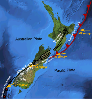
The Hikurangi Margin is New Zealand's largest subduction zone and fault.

On January 1, 1996, at 4:05 p.m. Central Indonesia Time, an earthquake with an epicenter in the Makassar Strait struck north of Minahasa on the island of Sulawesi, Indonesia. The earthquake measured 7.9 on the moment magnitude scale and was centered off Tolitoli Regency in Central Sulawesi, or 25 km from the Tonggolobibi village. A tsunami of 2–4 m (6.6–13.1 ft) was triggered by this earthquake as a result. At least 350 buildings were badly damaged, nine people died and 63 people were injured.

<span class="mw-page-title-main">2016 Solomon Islands earthquakes</span> Seismic events

On 9 December 2016 at 4:38 a.m. local time, the Solomon Islands region was rocked by an Mww 7.8 earthquake, centered 30 km off San Cristobal Island, about 61 km southwest of Kirakira, the capital of Makira-Ulawa Province. Initially registering magnitude 8.0, later downgraded to 7.8, the temblor prompted tsunami warnings that kept countries surrounding the Coral, Tasman and Solomon Sea on high alert, but was later cancelled. A large aftershock of magnitude 6.9 occurred shortly afterwards. This earthquake was largely felt, waking many residents who later ran to high ground for fears of a potential tsunami. The earthquake killed a child and affected some 34,000 people in Makira, South Malaita and Guadalcanal Island where many had lost their homes or had no access to basic needs. Earthquakes are common in this region, with little or no fatalities. This earthquake is tied with three other magnitude 7.8 earthquakes for the second largest earthquake of 2016. On 17 December, the Solomon Islands would be rattled again by a 7.9 magnitude earthquake, this time 54 km east of Taron, Papua New Guinea.

<span class="mw-page-title-main">2013 Craig, Alaska earthquake</span> Earthquake in Alaska and British Columbia

The 2013 Craig, Alaska earthquake struck on January 5, at 12:58 am (UTC–7) near the city of Craig and Hydaburg, on Prince of Wales Island. The Mw 7.5 earthquake came nearly three months after an Mw  7.8 quake struck Haida Gwaii on October 28, in 2012. The quake prompted a regional tsunami warning to British Columbia and Alaska, but it was later cancelled. Due to the remote location of the quake, there were no reports of casualties or damage.

The Nemuro-Oki earthquake in scientific literature, occurred on June 17 at 12:55 local time. It struck with an epicenter just off the Nemuro Peninsula in northern Hokkaidō, Japan. It measured 7.8–7.9 on the moment magnitude scale (Mw ), 8.1 on the tsunami magnitude scale (Mt ) and 7.4 on the Japan Meteorological Agency magnitude scale (MJMA ).

<span class="mw-page-title-main">2021 Chignik earthquake</span> 7th largest earthquake in the US

An earthquake occurred off the coast of the Alaska Peninsula on July 28, 2021, at 10:15 p.m. local time. The large megathrust earthquake had a moment magnitude of 8.2 according to the United States Geological Survey (USGS). A tsunami warning was issued by the National Oceanic and Atmospheric Administration (NOAA) but later cancelled. The mainshock was followed by a number of aftershocks, including three that were of magnitude 5.9, 6.1 and 6.9 respectively.

The 2021 Loyalty Islands earthquake was a 7.7 magnitude earthquake that struck offshore between Vanuatu and New Caledonia on February 11, 2021 at 00:19 local time. It is the 4th largest earthquake of 2021.

The 1555 Kashmir earthquake occurred at around midnight in the month of Ashvin in the Hindu calendar, or September in the Gregorian calendar, although the exact day of occurrence is not known. The earthquake seriously impacted the Kashmir Valley in present-day Pakistan and northwestern India. A moment magnitude (Mw ) of 7.6 to 8.0 and Modified Mercalli intensity of XII (Extreme) has been estimated for the earthquake. Thought to be one of the most destructive in the Kashmir Valley, the earthquake caused serious widespread damage and ground effects, killing an estimated 600–60,000 individuals.

The 2021 South Sandwich Islands earthquakes were a pair of powerful earthquakes, followed by many strong aftershocks which struck along the South Sandwich Trench in August 2021. The quakes measured 7.5 and 8.1 on the moment magnitude scale, according to the United States Geological Survey. The mainshock is tied with another event in 1929 as the largest earthquake ever recorded in this region, and is tied with the 2021 Kermadec Islands earthquake as the second largest earthquake of 2021.

The 1993 Finisterre Range earthquakes began on October 13 with a Mw  6.9 mainshock, followed by Mw  6.5 and 6.7 earthquakes. These earthquakes struck beneath the Finisterre Range, north of Markham Valley in Morobe Province, Papua New Guinea. The complex earthquake sequence seriously damaged many villages in the rural Eastern Papua New Guinea region, generating landslides and killing at least 60 people.

The 1885 Kashmir earthquake, also known as the Baramulla earthquake occurred on 30 May in Srinagar. It had an estimated moment magnitude of Mw  6.3–6.8 and maximum Medvedev–Sponheuer–Karnik scale intensity of VIII (Damaging). At least 3,081 people died and severe damage resulted.

<span class="mw-page-title-main">2002 Sandaun earthquake</span> Earthquake in Papua New Guinea

On September 9, 2002, a magnitude 7.6 earthquake struck off the coast of Wewak, Sandaun Province, Papua New Guinea. The shallow reverse earthquake triggered a local tsunami measuring 5 meters high. The disaster resulted in at least 6 deaths, 70 injuries and building damage.

The 1979 Yapen earthquake occurred on September 12 at 05:17:51 UTC. It had an epicenter near the coast of Yapen Island in Irian Jaya, Indonesia. Measuring 7.5 on the moment magnitude scale and having a depth of 20 km (12 mi), it caused severe damage on the island. At least 115 were killed due to shaking and a moderate tsunami.

The 1979 Saint Elias earthquake occurred near noon local time on the 28th of February. It measured Mw 7.4–7.6. Though the maximum recorded Modified Mercalli intensity was VII, damage was minimal and there were no casualties due to the remoteness of the faulting. The epicenter lies near the Alaskan border between America and Canada.

<span class="mw-page-title-main">1940 Shakotan earthquake</span> Earthquake in Japan

The 1940 Shakotan earthquake occurred on August 2 at 00:08:22 JST with a moment magnitude (Mw ) of 7.5 and maximum JMA seismic intensity of Shindo 4. The shock had an epicenter off the coast of Hokkaido, Japan. Damage from the shock was comparatively light, but the accomanying tsunami was destructive. The tsunami caused 10 deaths and 24 injuries on Hokkaido, and destroyed homes and boats across the Sea of Japan. The highest tsunami waves were recorded at the coast of Russia while along the coast of Hokkaido, waves were about 2 m.

References

  1. "USGS earthquake catalog". United States Geological Survey.
  2. Magnitude 8.0 NEW IRELAND REGION, P.N.G. Archived 2009-06-05 at the Wayback Machine United States Geological Survey
  3. "The New Ireland earthquakes of November 16, 2000, and the tsunami generated by the earthquake" (PDF). Archived from the original (PDF) on June 11, 2011. Retrieved July 9, 2009.
  4. Magnitude 7.8 NEW IRELAND REGION, P.N.G. Archived 2009-06-09 at the Wayback Machine United States Geological Survey
  5. Magnitude 7.8 NEW BRITAIN REGION, P.N.G. Archived 2009-06-09 at the Wayback Machine United States Geological Survey
  6. 1 2 3 4 5 6 Geist, Eric & Parsons, Tom. (2005). Triggering of tsunamigenic aftershocks from large strike-slip earthquakes: Analysis of the November 2000 New Ireland earthquake sequence. Geochem. Geophys. Geosyst. 6. doi : 10.1029/2005GC000935.
  7. Significant Earthquakes of the World 2000
  8. Magnitude 7 and Greater Earthquakes in 2000
  9. Tregoning, P.; Jackson, R.J.; McQueen, H.; Lambeck, K.; Stevens, C.; Little, R.P.; Curely, R.; Rosa, R. (1999). "Motion of the South Bismarck Plate, Papua New Guinea". Geophysical Research Letters. 26 (23): 3517–3520. Bibcode:1999GeoRL..26.3517T. doi:10.1029/1999GL010840. S2CID   15968691.
  10. 1 2 3 4 5 Park, S.-C.; Mori, J. (2007). "Triggering of earthquakes during the 2000 Papua New Guinea earthquake sequence". Journal of Geophysical Research: Solid Earth. 112 (B3). Bibcode:2007JGRB..112.3302P. doi: 10.1029/2006JB004480 .
  11. Tregoning, P.; Sambridge, M.; McQueen, H.; Toulmin, S.; Nicholson, T. (2005). "Tectonic interpretation of aftershock relocations in eastern Papua New Guinea using teleseismic data and the arrival pattern method". Geophysical Journal International. 160 (3): 1103–1111. Bibcode:2005GeoJI.160.1103T. doi: 10.1111/j.1365-246X.2005.02567.x .
  12. Galloway, D.; Walker, A. (2001). "A Summary of Earthquakes in 2000" (PDF). SEDED Newsletter Volume 15 No. 1.