
The 2006 Greece earthquake – also known as the Kythira earthquake – occurred on January 8 at 13:34:53 local time and was felt throughout the entire eastern Mediterranean basin. The earthquake an magnitude 6.7 and a maximum Mercalli intensity of VII. Its epicentre was located just off the island of Kythira about 200 kilometres (120 mi) south of Athens.
On 25 November 2000, at 22:09, a Mw 6.8 earthquake struck with an epicenter just offshore Baku, Azerbaijan. It was followed a minute later by a Mw 6.5 event. The mainshock resulted in 35 mostly indirect fatalities and 600 injuries.

The 2002 Hindu Kush earthquakes struck in northern Afghanistan during the month of March. At least 166 people were killed with a very large and intermediate-depth mainshock on March 3. Three weeks later, at least 1,200 were killed during a moderate but shallow event that had a maximum Mercalli intensity of VII. The M7.4 and M6.1 reverse events were focused in the Hindu Kush mountain range area.

The 2007 Bengkulu earthquakes were a series of megathrust earthquakes that struck the Sunda Trench off the coast of Sumatra, Indonesia, with three of magnitude 7 or greater. A series of tsunami bulletins was issued for the area. The most powerful of the series had a magnitude of 8.4, which makes it in the top 20 of the largest earthquakes ever recorded on a seismograph.

On 4 June 2000, at 23:28 WIB, southern Sumatra in Indonesia was struck by an earthquake of 7.9 with a maximum Mercalli intensity of VI (Strong). The event occurred off the coast near Enggano Island. There were more than 100 fatalities and up to 2,585 injuries. Over 340 aftershocks shook the area throughout the rest of 2000, one just eleven minutes after the mainshock.
The 1929 Kopet Dag earthquake took place at 15:37 UTC on 1 May with a moment magnitude of 7.2 and a maximum Mercalli intensity of IX (Violent). It occurred in the Kopet Dag area of Iran and caused up to 3,800 casualties along the Iran-Turkmenistan border. More than 1,100 were injured.

In the early morning hours of August 16, 1931, a powerful earthquake occurred in West Texas with a maximum Mercalli intensity of VIII (Severe). Estimates of its magnitude range between 5.8 and 6.4 mb, making it the most powerful earthquake ever recorded in Texas history. Its epicenter was near the town of Valentine, Texas; there, the earthquake caused damage to many homes and buildings. The earthquake may have been caused by movement along oblique-slip faulting in West Texas, the most seismically active region in the state. Shaking from the earthquake was perceptible within a 400 mi (640 km) radius of the epicenter, affecting four U.S. states and northern Mexico. Several foreshocks and aftershocks accompanied the primary temblor, with the aftershocks continuing until at least November 3, 1931. The main earthquake caused no fatalities, though several people sustained minor injuries; the damage in Valentine amounted to $50,000–$75,000.
Three powerful earthquakes struck the islands of New Britain and New Ireland, Papua New Guinea on 16-17 November 2000, starting with a Mw 8.0–8.2 strike-slip event that occurred on November 16 at 04:54:56 UTC. A Mw 7.3–7.8 thrust earthquake followed at 07:42:16 UTC with its epicenter 170 km (110 mi) southeast of the first event at the southern end of its rupture zone south of New Ireland. Another Mw 7.3–7.8 thrust event occurred on November 17 at 21:01:56 UTC, occurring 174 km (108 mi) southwest of the first event with an inland epicenter at Pomio District, East New Britain Province.
The 1984 San Pedro Basin earthquake occurred on June 24 at with a moment magnitude of 6.7 and a maximum Mercalli intensity of VII. The event occurred off the southern coast of the Dominican Republic and resulted in an estimated five fatalities.
The 2010 Mindanao earthquakes occurred in the southern Philippines in the Moro Gulf. This was a complex sequence of events including three main events of magnitude 7.3 or greater on the 23rd of July, and two significant aftershocks of magnitude 6.6 on the 24th and 29th. All of these were deep focus earthquakes, at depths from 565 km (351 mi) to 634 km (394 mi). This resulted in minimal, but very widespread shaking at the surface, with a maximum intensity of IV on the PEIS scale; consequently there were no reports of casualties or damage.
The 2002 Burica earthquake occurred on off the coast of Panama. It had a magnitude of 6.5. The epicenter was located off the southeastern coast of Burica Peninsula, close to the Costa Rica–Panama border. Some homes collapsed and at least 11 people were reported injured, both in Panama and in Costa Rica. The strongest intensity reached VII in Puerto Armuelles, Panama. It was felt with III (Weak) to IV (Light) around San Jose, Costa Rica. Shops in the center of Puerto Armuelles suffered from loss such as fallen merchandise and broken window glass. This earthquake occurred along the Panama fracture zone.
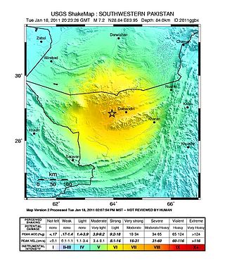
The 2011 Dalbandin earthquake occurred on with a moment magnitude of 7.2 and a maximum Mercalli intensity of VII. The shock occurred in a sparsely populated area of Balochistan, caused moderate damage, three deaths, and some injuries.
The 1957 San Francisco earthquake occurred on March 22 at 11:44:22 local time with a moment magnitude of 5.7 and a maximum Mercalli Intensity of VII. It was located just off the San Francisco Peninsula near the San Andreas Fault and was felt in a limited portion of Northern and Central California. There was a non-destructive foreshock and aftershock sequence that lasted for several months. With financial losses of around US$1 million, damage was considered minimal, with one death and forty injuries.
The 1999 Aïn Témouchent earthquake occurred on December 22 at in northern Algeria. The dip-slip event had a moment magnitude of 5.6 and a maximum Mercalli intensity of VII. At least 22 were killed, 175 were injured, and 15,000–25,000 were made homeless. The Belgian Centre for Research on the Epidemiology of Disasters' EM-DAT database and the USGS' National Geophysical Data Center both list financial losses of $60.93 million.
On 4 May 2000 at 12:21 WITA, a 7.5 earthquake struck off the coast of Banggai Islands Regency, Central Sulawesi, Indonesia, which was followed by a damaging local tsunami. The earthquake and tsunami killed at least 54 people and injured 270 others, with most of the damage and casualties occurring in the Banggai Islands.
In 1954, the state of Nevada was struck by a series of earthquakes that began with three magnitude 6.0+ events in July and August that preceded the Mw 7.1–7.3 mainshock and M 6.9 aftershock, both on December 12. All five earthquakes are among the largest in the state, and the largest since the Cedar Mountain earthquake of 1932 and Pleasant Valley event in 1915. The earthquake was felt throughout much of the western United States.
The 2021 Assam earthquake struck 11 km away from Dhekiajuli, Assam, India at 07:51 (IST) on April 28, 2021 with a moment magnitude of 6.0 at 34.0 km (21.1 mi) depth. The quake struck with an epicenter 140 km north of the main city of Guwahati. It resulted in two fatalities and at least 12 injuries.
On 9 July 2019, at 8:36 PM (PST), an earthquake measuring 5.6 jolted the province of North Cotabato, Davao del Sur, and other nearby provinces. The National Disaster Risk Reduction and Management Council reported one dead and three injured in Makilala after the earthquake, and a total of 164 families affected in Cotabato Province. Near the epicenter of the earthquake, the severity of strong ground motion was assigned VI (Strong) on the Modified Mercalli intensity scale. A total of 106 schools, 119 houses, and 14 other infrastructures were damaged by the earthquake.
On 29 November, at 14:10 UTC, a magnitude 7.7 earthquake struck off the southern coast of Taliabu Island Regency in North Maluku, Indonesia. At least 41 people were killed on the nearby islands and a tsunami was triggered. Several hundred homes, buildings and offices were damaged or destroyed.
The February 2004 Nabire earthquakes began on February 6 at 06.05 WIT in Nabire Regency, Central Papua, Indonesia. The first of three large earthquakes measured 7.0 on the moment magnitude scale (Mw ). It was followed a few days later by two strong shocks, measuring Mw 7.3 and 6.7, respectively. The earthquakes were felt at Nabire with a maximum Mercalli intensity of VI (Strong). At least 37 people were killed and were 682 injured, and over 2,600 buildings were damaged or destroyed.

