
Sorsogon, officially the Province of Sorsogon, is a province in the Philippines located in the Bicol Region. It is the southernmost province in the island of Luzon and is subdivided into fourteen municipalities (towns) and one city. Its capital is Sorsogon City and borders the province of Albay to the north.
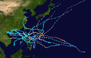
The effects of the 2009 Pacific typhoon season in the Philippines were considered some of the worst in decades. Throughout the year, series of typhoons impacted the country, with the worst damage occurring during September and October from Typhoons Ketsana (Ondoy) and Parma (Pepeng).

Tropical Storm Aere, known in the Philippines as Tropical Storm Bebeng, was a mild tropical storm that affected eastern Philippines and southern Japan. It was the first named storm of the 2011 Pacific typhoon season. Aere is the Marshallese word for storm.
Severe Tropical Storm Rumbia, known in the Philippines as Tropical Storm Gorio, was a tropical cyclone that brought widespread flooding in areas of the Philippines and China late June and early July 2013. The sixth internationally named storm of the season, Rumbia formed from a broad area of low pressure situated in the southern Philippine Sea on June 27. Steadily organizing, the initial tropical depression moved towards the northwest as the result of a nearby subtropical ridge. On June 28, the disturbance strengthened to tropical storm strength, and subsequently made its first landfall on Eastern Samar in the Philippines early the following day. Rumbia spent roughly a day moving across the archipelago before emerging into the South China Sea. Over open waters, Rumbia resumed strengthening, and reached its peak intensity with winds of 95 km/h (50 mph) on July 1, ranking it as a severe tropical storm. The tropical cyclone weakened slightly before moving ashore the Leizhou Peninsula late that day. Due to land interaction, Rumbia quickly weakened into a low pressure area on July 2 and eventually dissipated soon afterwards.

The effects of the 2013 Pacific typhoon season in the Philippines were considered some of the worst in decades. Throughout the year, a series of typhoons impacted the country, with the worst impacts coming from Typhoon Haiyan, especially in death toll, during November.
Typhoon Melor, known in the Philippines as Typhoon Nona, was a powerful tropical cyclone that struck the Philippines in December 2015. The twenty-seventh named storm and the eighteenth typhoon of the annual typhoon season, Melor killed 51 people and caused ₱7.04 billion in damage.
Tropical Storm Haikui, known in the Philippines as Tropical Storm Salome, was a weak tropical cyclone that affected the Philippine archipelagos of Luzon and Visayas. Forming as the twenty-fourth named storm of the 2017 typhoon season, Haikui developed as a tropical depression to the east of Samar on November 9. Traversing some Philippine islands, the system gradually intensified into a named tropical storm by November 10. In that same day, Haikui emerged to the South China Sea. By November 12, the Japan Meteorological History downgraded the storm into a tropical depression. The storm dissipated on November 13, while meteorologists from the USA recorded the storm until November 14.

Tropical Storm Kai-tak, known in the Philippines as Tropical Storm Urduja, was a late-season tropical cyclone that affected the Philippines during December 2017. The twenty-sixth named storm of the 2017 Pacific typhoon season, Kai-tak started as a tropical depression near Palau on December 11. After slowly intensifying, the system became a tropical storm on December 14. Due to its slow motion, Kai-tak made landfall in Samar on December 16 and traversed the Philippine Islands. Kai-tak later moved in a west-southwestward direction until it dissipated on December 23 near Malaysia.

Tropical Depression Usman was a weak but deadly tropical cyclone that impacted the southern Philippines in December 2018. Tropical Depression Usman originated first as a low-pressure area to the east of Palau on December 23. Slowly intensifying, the system became a tropical depression two days later. The system maintained its intensity while moving in a general west-northwestward direction approaching the eastern portion of the Philippine islands. However, due to unfavorable conditions, the depression weakened into a remnant low on December 29, while making landfall over Eastern Samar thereafter.

Typhoon Kammuri, known in the Philippines as Typhoon Tisoy, was a powerful typhoon which impacted the Philippines in early December 2019. Kammuri, which means crown or Corona Borealis in Japanese, the twenty-eighth named storm and sixteenth typhoon of the 2019 Pacific typhoon season, Kammuri developed from a tropical wave situated a couple hundred kilometers south of the Mariana Islands. From November 25 to 27, the system tracked westward at a steady pace and rate of intensification, first making minor impacts in Guam. On November 28, the system intensified into a typhoon as environmental conditions became marginally conducive for significant development. From November 29 to December 1, Kammuri was unable to strengthen to previous estimates due to its near stationary movement as a result of weak steering currents, upwelling itself consequently. On December 2, the system tracked westward at a much faster speed of 19 km/h (12 mph) and rapidly intensified over warm Philippine Sea waters, before making landfall in the Bicol Region of the Philippines at peak intensity as a category 4-equivalent typhoon.

Typhoon Vongfong, known in the Philippines as Typhoon Ambo, was a strong tropical cyclone that impacted the Philippines in May 2020. Beginning as a tropical depression on May 10 east of Mindanao, Vongfong was the first storm of the 2020 Pacific typhoon season. It gradually organized as it took a slow northward course, strengthening into a tropical storm on May 12 and curving west thereafter. The next day, Vongfong entered a period of rapid intensification, becoming a typhoon and attaining 10-minute maximum sustained winds of 150 km/h (93 mph). The storm made landfall at this intensity near San Policarpo, Eastern Samar, at 04:15 UTC on May 14. The system tracked across Visayas and Luzon, making a total of seven landfalls. Persistent land interaction weakened Vongfong, leading to its degeneration into a tropical depression over the Luzon Strait on May 17.

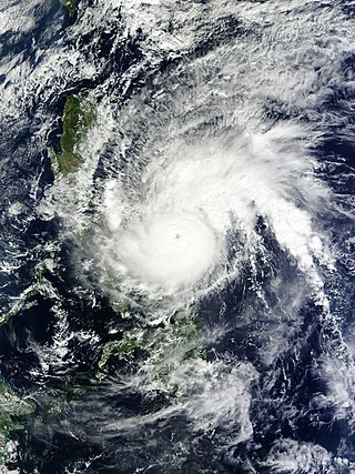
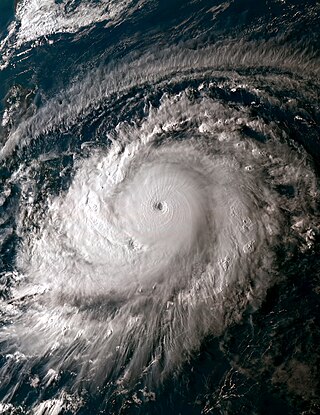
Typhoon Goni, known as Super Typhoon Rolly, was an extremely powerful tropical cyclone that made landfall as a Category 5 equivalent super typhoon on Catanduanes in the Philippines, and in Vietnam as a tropical storm. It is the strongest landfalling tropical cyclone on record by 1-minute maximum sustained winds. The name "Goni" means swan in Korean. The nineteenth named storm, ninth typhoon, and second super typhoon of the 2020 Pacific typhoon season, Goni originated as a tropical depression south portion of Guam on October 26. It was then named as Tropical Storm Goni on October 27. On the next day, Goni explosively intensified over the Philippine Sea, becoming a Category 5–equivalent super typhoon on October 30. Goni maintained Category 5 strength for over a day, before making landfall on Catanduanes at peak intensity, with 10-minute sustained winds of 220 km/h (140 mph), and 1-minute sustained winds of 315 km/h (195 mph), with a minimum central pressure of 905 hPa. It was the most intense tropical cyclone observed worldwide in 2020.
Typhoon Surigae, known in the Philippines as Super Typhoon Bising, was the strongest tropical cyclone worldwide in 2021 and the most powerful to form before the month of May in the Northern Hemisphere in any calendar year. The second named storm, first typhoon and first super typhoon of the 2021 Pacific typhoon season, Surigae originated from a low-pressure area south of the Micronesian island of Woleai. The low organized into a tropical depression on April 12. At 18:00 UTC that day, it strengthened into a tropical storm and was named Surigae by the Japan Meteorological Agency (JMA). Very favorable environmental conditions then allowed Surigae to begin a bout of rapid intensification after becoming a typhoon on April 15; by April 17, the storm reached its peak intensity with 10-minute sustained winds of 220 km/h (140 mph), 1-minute sustained winds of 315 km/h (195 mph), and a minimum pressure of 895 hPa (26.4 inHg). Afterward, weakening outflow and an eyewall replacement cycle caused Surigae to gradually weaken as its track shifted north-northwestward in the Philippine Sea. Following the eyewall replacement cycle, Surigae became an annular tropical cyclone on April 19, and restrengthened slightly. On April 22, the storm began to rapidly weaken as it accelerated northwestward into unfavorable environmental conditions, transitioning into a subtropical storm the next day. The subtropical system subsequently underwent extratropical transition, which it completed by April 24. Three days later, Surigae's remnant explosively intensified into a bomb cyclone near the Aleutian Islands, attaining hurricane-force winds. Afterward, the system gradually weakened as it turned eastward, crossing the International Date Line on April 30 and fully dissipating that same day.

Tropical Storm Choi-wan, known in the Philippines as Tropical Storm Dante, was a tropical storm which caused moderate flooding and damage in the Philippines and also affected Taiwan. The third named storm of the 2021 Pacific typhoon season, Choi-wan originated from an area of low pressure, located south-southeast of Guam near a brewing system. Fueled by an environment favorable for tropical cyclogenesis, it developed into a tropical depression, two days later as it moved westward. At 00:00 UTC on May 31, the system strengthened to a tropical storm and was named Choi-wan by the JMA. Although the storm was still located in the conductive conditions off the Philippine Sea while moving northwestward, a tropical upper tropospheric trough to the northeast halted the system's intensification, with Choi-wan's convection displaced to the south of its circulation on satellite imagery.

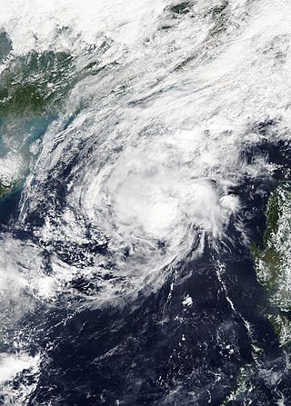
Severe Tropical Storm Conson, known in the Philippines as Typhoon Jolina, was a strong tropical cyclone that impacted the central Philippines and Vietnam during the early September 2021. Being the thirteenth named storm of the said event, Conson originated as a low-pressure area first monitored approximately 500 km (310 mi) west of Guam. It formed as a tropical depression over the Pacific Ocean on September 5, 2021. As it formed within the Philippine Area of Responsibility, the Philippine Atmospheric, Geophysical, and Astronomical Services Administration (PAGASA) named the storm Jolina. Over the next day, it intensified into a tropical storm and was named Conson by the Japan Meteorological Agency (JMA). As the storm neared Samar Island, it intensified into a severe tropical storm, and later into a typhoon according to the PAGASA prior to its first landfall in Eastern Samar. The storm retained its strength as it crossed Visayas and later Calabarzon before weakening over Manila Bay prior to its final landfall in Bataan. It subsequently emerged into the South China Sea where it struggled to reintensify further. It then weakened into a tropical depression just offshore of Vietnam before moving ashore near Da Nang. It then rapidly weakened before dissipating on September 13.

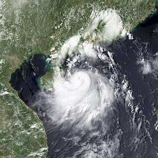
Severe Tropical Storm Nalgae, known in the Philippines as Severe Tropical Storm Paeng, was a very large and deadly tropical cyclone that wreaked havoc across the Philippines and later impacted Hong Kong and Macau. Nalgae, meaning wing in Korean, the twenty-second named storm of the 2022 Pacific typhoon season, Nalgae originated from an invest located east of the Philippines on October 26. The disturbance, initially designated as 93W, was eventually upgraded the following day to a tropical depression by the Joint Typhoon Warning Center (JTWC) and re-designated as 26W. The Japan Meteorological Agency (JMA) however, had already considered the disturbance as a tropical depression a day prior to JTWC's; the Philippine Atmospheric, Geophysical and Astronomical Services Administration (PAGASA) also followed the JMA's lead and gave it the name Paeng. That same day, it was upgraded again by the JMA to tropical storm status, thus gaining the name Nalgae.

In December 2022, a series of floods began to severely affect the provinces of Misamis Occidental and Misamis Oriental, and some parts of the southern island of Mindanao in the Philippines. The floods were caused by intense rain, which poured down on the central and southern parts of the country.

Severe Tropical Storm Trami, known in the Philippines as Severe Tropical Storm Kristine, was a large and catastrophic tropical cyclone that wreaked havoc across the Philippines and later impacted Vietnam, Thailand, and China in October 2024. It was also the first tropical cyclone in a series to impact the Philippines in late 2024, before Typhoons Kong-rey, Yinxing, Toraji, Usagi, and Man-yi.
