In 2024, 62,131 wildfires detected by the Global Wildfire Information System (GWIS) burned an estimated 46,101,798 hectares (113,920,020 acres) of tropical wetland in Brazil's Pantanal in Mato Grosso do Sul, the Amazon rainforest, and the Cerrado.[1] According to satellite data from the Brazilian National Institute for Space Research, the number of fires from 2024's beginning to 10 June showed a 935% increase compared to the same period in 2023 with 1,315 fires being reported compared to 127 fires in 2023.[2][3]
Climate scientists noted that the 2024 Brazil wildfire season started earlier than typical seasons which start around July, and was also more intense this year due to decreased rainfall in certain regions leading to prolonged drought.[4] Brazilian President Luiz Inacio Lula da Silva pledged to stop illegal deforestation in the Amazon by 2030 to help reduce the impact of global warming.[3]
Wildfires
On 1 July, collected satellite data indicated that at least 13,489 wildfires had occurred since the start of the year, the most amount of wildfires in the first half of the year in 20 years, and up 61% from 2023. Brazilian Greenpeace spokesman Romulo Batista stated that global warming and decreased rainfall created dryer environments that caused vegetation to be more dry and thus be more susceptible to spreading fires.[3]
Pará
On 27 August, the governor of Pará, Helder Barbalho, declared a state of emergency and prohibited the use of fire statewide due to the fires that are affecting cities throughout the state. The decree provides for the prohibition of the use of fire, including for cleaning and managing areas, throughout Pará, for a period of 180 days, with the possibility of being extended for the same period.[5]
Pantanal
Throughout the first two weeks of June, 2,639 fires burned 32,000 hectares (79,000 acres) of the Pantanal wetlands, six times the highest number of fires in the region for June compared to any prior year.[6] The number rose to over 760,000 hectares (1.9million acres) by 9 July, burning over 4% of the 16.9million hectares (42million acres) of wetland. Massive areas of land bearing thick shrubbery and wildlife were burnt into a "carpet of white ash" with pieces of debris rising and falling around the affected areas. The intensity and range of the wildfires were exacerbated by strong winds blowing at up to 40 km per hour.[7] The prominent fires threatened many of the natural fauna including anteaters, jaguars, tapirs, caimans, and anacondas. A total of 3,538 wildfires were recorded in the region up to 1 July, up 40% compared to 2020, the year with the most wildfires in the region. Efforts to extinguish the fires were complicated by high winds and the terrain of the wetlands making access and movement difficult.[2][3]
The smoke from the wildfires caused several hospitals in Corumbá to fill with victims of smoke inhalation and respiratory symptoms, affecting children <5 years old) and senior citizens over 65 the worst. Animal rescue workers reported hundreds of animals were killed due to smoke inhalation and burns, which included frogs, snakes, monkeys, and jaguars.[7]
On 31 August, IBAMA fined two companies more than R$ 100 million for a massive fire in the Pantanal caused by maintenance workers on a railway line in Corumbá. The fire, which started on 16 August and was brought under control on 23 August, destroyed more than 17,000 hectares (42,000 acres) of vegetation and affected 12 rural properties in the Porto Esperança region. The company responsible for the railway line was fined R$ 50 million for environmental damage and R$ 7.5 million for failure to comply with environmental licensing, while the outsourced company was fined R$ 50 million.[8]
On 7 September, IBAMA authorized the sending of firefighters to Bolivia to combat forest fires that pose an imminent risk to the Pantanal.[9]
Cerrado
The Cerrado had 13,229 wildfires occur in the first half of the year. The widespread fires caused the sky to fill with smoke clouds and turn a red color, according to residents.[3]
São Paulo
Development of fires in São Paulo on 22 August 2024Firefighting operation being prepared at the Leite Lopes Airport on 25 August
In late August, wildfires caused by prolonged drought conditions and strong wind gusts impacted thirty cities in São Paulo state, either directly affecting them or burning near them. As a result, at least two people were killed at an industrial plant in Urupês while trying to contain a nearby wildfire.[10]
On 24 August 2024, two matches of football were suspended after a municipal decree. The fires that hit the city of Ribeirão Preto and the region associated with the drought and extreme heat caused the suspension of the Copa Paulista and Série B do Brasileiro matches that were scheduled to take place in the same month in the city.[11]
On 25 August 2024, São Paulo governor Tarcísio de Freitas confirmed the arrest of two people suspected of acting in arson attacks in the interior of São Paulo since the beginning of the task force to contain the spread of flames in the state. According to the Chief Executive, a suspect was arrested in the region of São José do Rio Preto on 24 of the same month and another was detained on 25 in Batatais, both in the state of São Paulo. The man arrested on day 25 is a 42-year-old mechanic, caught by the Military Police of São Paulo State while setting fire to a forest near the central region of Batatais after an anonymous tip. A bottle of gasoline, a lighter and his cell phone were seized from him. He was taken to the police station to give a statement. According to the investigation carried out at the scene, in videos found on the device, the man celebrated large-scale fires in the region.[12]
On 26 August, in an interview to the program CBN São Paulo, transmitted by CBN Radio, Tarcísio stated that one of the people arrested for involvement in fires in Batatais, in the interior of São Paulo, “identified himself as a member of the Capital's First Command”. The state's Secretariat of Public Security reported that the perpetrator told the police that he was part of the criminal organization.[13] On the same day, four men in Batatais, Guaraci, São José do Rio Preto and Jales were arrested on suspicion of participating in the fires that hit the interior of São Paulo.[14][15]
On 27 August, a 32-year-old man was arrested on suspicion of setting fire to a wooded area on the banks of the Archimedes Lammoglia Highway (SP-075), in Salto.[16]
On the night of 28 August, the Military Police of São Paulo State arrested two men suspected of setting fire to a vegetation area on the side of the Fábio Talarico Highway, in Franca.[16][17]
In total, 20 people have been arrested for starting forest fires in the state of São Paulo since the first perpetrator was detained on 24 August.[18][12]
Rio de Janeiro
On 13 September, a man was arrested after being caught setting fire to a wooded area in Vassouras, in the south of Rio de Janeiro. Moreover, a fire hit the oldest quilombo of the state, in Valença.[19]
On 14 September, State Environment Secretary Bernardo Rossi announced the closure of all parks in Rio de Janeiro because of fires across the state.[19]
Federal District
On the morning of 15 September, a forest fire began to spread through the region of the Brasília National Park, also known as the Mineral Water Park. In the early evening, the president of ICMBio, Mauro Pires, said that the fire is criminal. According to him, the fire started in Granja do Torto and continued towards the Brasília National Park.[20]
Response
In April, state authorities of Mato Grosso do Sul proclaimed an "environmental state of emergency" due to low levels of rainfall disrupting the usual seasonal flooding, exacerbating conditions for potential wildfires in many parts of the region.[2]
Mato Grosso do Sul's state government would then issue an emergency declaration on 24 June. Brazil's federal government increased the size of its wildfire response taskforce, while Brazil's air force dropped 48,000 liters (11,000impgal; 13,000U.S.gal) of water on July 6-7. Firefighter Cabo Sena reported that wildfires would often reignite within 24 hours of them being put out. Fire prevention leaflets were distributed to local civilians in the region of the wildfires, with several experts and citizens requesting that Brazil's government invests more in fire prevention education.[7]
In August 2024, the Bolivian government has asked Brazil for support in fighting forest fires. In the Pantanal, a border area between the countries, the Serra do Amolar was recently hit by fire. The request for help was sent to the Brazilian Cooperation Agency (ABC) and is being evaluated by the Brazilian Ministry of Foreign Affairs.[21]
Ribeirão Preto is a municipality and a metropolitan area located in the northeastern region of São Paulo state, Brazil.
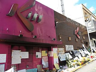
The Kiss nightclub fire started between 2:00 and 2:30 a.m. (BRST) on 27 January 2013 in Santa Maria, Rio Grande do Sul, Brazil, killing 242 people and injuring at least 630 others. The acoustic foam in the ceiling was ignited. It was because outdoor fireworks were used indoors causing the ceiling foam to catch fire, creating a fireworks accident and nightclub fire. The premises having only one exit contributed to the high death toll as well as the electricity going out, making it impossible to find the exit with the layout the way it was. The only light in the building was coming from the bathroom where people flocked, only to be trapped with no way out as they believed it was an exit. It is the second deadliest fire in Brazilian history, surpassed only by the Niterói circus fire of 1961.
Virada Cultural Paulistana is the biggest 24-hour festival in the world, that began in 2005 and occurs annually in the city of São Paulo, Brazil. Events at the Virada Cultural include various live music concerts, films, plays, art exhibits, and other cultural activities and performances. In 2019, has a public expectation of 5 million people and will be the biggest edition of the festival ever held. The event will contain more than 250 event venues, and will feature more than 1200 confirmed attractions.
Roger Abdelmassih is a Brazilian former physician, an expert on human reproduction, and one of the pioneers of in-vitro fertilization in Brazil. In early 2009 he was accused of sexually abusing sedated patients. Abdelmassih was sentenced to 278 years in prison for 52 rapes and 39 attempted sexual abuses on women.
Events in the year 2001 in Brazil.
Events in the year 2018 in Brazil.
The Wilton Paes de Almeida Building was a high-rise building in Largo do Paissandú, São Paulo, Brazil, that was built in the 1960s. It was listed as a historic building in 1992. It was the headquarters of the Federal Police in São Paulo from the 1980s until 2003, after which it was occupied by squatters. It caught fire and collapsed on 1 May 2018, causing at least 7 fatalities.
Events in the year 2019 in Brazil.
Pedro Gabriel Pereira Lopes, commonly known as Pedrinho, is a Brazilian professional footballer who plays as a forward for Cuiabá on loan from the Russian club Lokomotiv Moscow.
Events in the year 2020 in Brazil.
The 2020 Campeonato Paulista Série A3 is the 27th season of the third level of the São Paulo state league under its current title and the 67th season overall.
The 2020 Brazil rainforest wildfires were a series of forest fires that were affecting Brazil, with 44,013 outbreaks of fires registered between January and August in the Amazonas and Pantanal. Within the Amazon, 6,315 outbreaks of fire were detected in the same period. Within the Pantanal, the volume of fires is equivalent to those of the past six years and there have been actions by NGOs and volunteers to save endangered animals, such as the jaguar. It was expected that the health systems of the Amazon region, already overloaded by the COVID-19 pandemic, would be even more overloaded due to respiratory diseases due to smoke emitted by the wildfires.
Events in the year 2021 in Brazil.
The 2021 Brazilian protests were popular demonstrations that took place in different regions of Brazil in the context of the COVID-19 pandemic. Protests both supporting and opposing the government happened.
Events in the year 2022 in Brazil.
The 2022–2023 Brazilian election protests began shortly after the conclusion of the 2022 Brazilian general election's second round on 30 October, in which Luiz Inácio Lula da Silva was elected president, which led to mass protests and roadblocks nationwide. Supporters of Jair Bolsonaro, who are frequently referred to in media accounts as Bolsonaristas, alleging election fraud, began blocking roads and highways in the country. At least 23 Brazilian states, plus the Federal District, recorded roadblocks as of 1 November, adding up to at least 267 roadblocks according to data from Federal Highway Police (PRF).
Events in the year 2023 in Brazil.
Events in the year 2024 in Brazil.
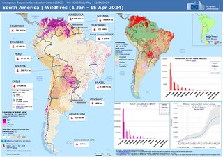
The 2024 South American wildfires refer to a mega colossal series of wildfires that significantly impacted several neighboring South American countries, including Bolivia, Brazil, Chile, Colombia, Ecuador, and Peru. Based on Global Wildfire Information System satellite imaging, about 346,112 wildfire hotspots damaged or destroyed 85,866,867 hectares. The massive area burned was primarily caused by anthropogenic climate change and the resulting consequences of the 2023–2024 South American drought on fire conditions. The wildfires caused significant deforestation of the Amazon rainforest, and also impacted several other international biomes including the Pantanal wetlands, becoming the second largest series of wildfires in the 21st century next to the 2023–24 Australian bushfire season, with the 2024 Brazil wildfires alone reaching fourth in area burned.
This page is based on this Wikipedia article Text is available under the CC BY-SA 4.0 license; additional terms may apply. Images, videos and audio are available under their respective licenses.