Abanilla occupies a surface area of 236.6km2 and is situated 222 metres above sea level.[2] It lies on a natural foundation which has been degraded by a number of aggregate and marblequarries.
Paleontological Significance
A karstic paleontological site is located on the southeast slope of the Sierra de Quibas in an abandoned limestone quarry. Researchers have discovered vertebrate and invertebrate fossils at this site.[3] They collected rodent fossils and used dental patterns to identify these to be of the Muroidea subfamily Arvicolinae. Using stratigraphic and sedimentological features in the limestone, the scientists were able to date these fossils to the Early Pleistocene subepoch.[4]
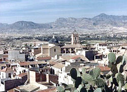
Points of interest
Points of interest in Abanilla include the Old Town (containing the monument to the Corazón de Jesús), the Fuente de Algarrobo (Fountain of the carob tree), the Santuario de Mahoya (Sanctuary of Mahoya), and the Iglesia Parroquial de San José (Parochial Church of St. Joseph). Other sights worth visiting include the source of the River Chícamo and the mountains of Abanilla and Quibas.
Monuments
Buildings of monumental significance in Abanilla include the La Iglesia de San José (the Church of San José) (18th century), El Sagrado Corazón (Sacred Heart) in Abanilla Town and Barinas, La Casa de la Encomienda, La Casa Cabrera, La Casa Pintada, El Monumento a las Fiestas de Moros y Cristianos (the Monument to the Festivals of the Moors and Christians) and La casa del francés (the French's house).[5][6][7]
Other communities include Mahoya, El Cantón, Cañada de la Leña, El Partidor, El Tollé, Los Baños de Fortuna, Casa Cabrera, Casa Pintada, Los Carrillos, La Umbría, Collado de los Gabrieles, Ricabacica, El Algarrobo, Campules, Balonga, Mafraque and El Olivar.
History
There has been presence of human beings since the Paleolithic. Lithic workplaces corresponding to that era were found in the Southern half of the municipality.[10][11][12]
This current municipality was also inhabited by people during the first centuries of the Ancient Era (from the 5th century to the 3rd in this case) by Iberians. There is a former settlement in the Northwest end it also occurs in Fortuna and Jumilla and another one in the south.[13]
There were also people inhabitance and structures corresponding to the period when Romans ruled the Iberian Peninsula. A Roman road (via romana) traversed Abanilla and there are remains of it. Another site dating back from that era is a former Roman villa.[14][15]
A war with conquer purposes begin in the Iberian Peninsula in 711. Muslim peoples intended to rule the peninsula and conquered large part of it from the starting year to 726. The nobleman Theodemir did an agreement with the governor Abd al-Aziz ibn Musa in 713 which name is Treaty of Orihuela. The treaty lead Abd al-Aziz to rule territory between Vinalopó and Segura rivers. Consequently, Abanilla had dependency on Orihuela during the Muslim Iberian Peninsula era.[16]
A structure that originated in that period is the alcazaba (Arab fortification) of the town.[16]
The king of the Taifa of Murcia signed the Treaty of Alcaraz, which consisted in conferring vassalage to the Crown of Castile, in 1243. Muslims were allowed to stay, and keep their religion, customs, organisations, etc. provided they paid extra taxes. In this era, Abanilla ceases being part of Orihuela because the first one belonged to Castile and the second one to Aragon.[16]
In 1613, the king Ferdinand III of Castile ruled the expulsion of the Muslims. As there were rather many of them in Abanilla (over 1,000), the town turned out not to have enough workers for land labouring and that caused an economic downturn, which lasted for a century.[17]
There had been an increase in population in the 18th century and there were over 7,000 inhabitants in that century. New dwellings and buildings were necessarily built beyond the town-surrounding wall. Many important buildings of the municipality were constructed during this century.[17]
In the third quarter of the 20th century, water canals were built in Abanilla and drinking water supply begin to exist in the municipality.[18]
Population levels from 1900 to 2005 in comparison with the comarca as a whole
The population of Abanilla is 6,510 as of 2011.[19]
Demographic evolution in Abanilla 1857–2008
1857
1860
1877
1887
1897
1900
1910
1920
1930
1940
1950
1960
4.324
4.650
5.689
5.617
6.121
6.634
7.451
7.641
8.179
8.220
8.620
8.594
1970
1981
1991
1996
2001
2002
2003
2004
2005
2006
2007
2008
8.675
7.049
5.827
6.130
6.033
6.040
6.239
6.145
6.245
6.333
6.568
6.642
Economy
Agriculture has a high weight in the municipality. 28.8% of the territory is used as crops lands.[20] The most wide grown products are the citrus, the almonds and the grapes.[21] Almost 55.2% of the agreements were made for agriculture and fishing activities in 2019 and 30.15% of the workers signed agreements for work as labourers. 29.6% of the agreements were written for posts in the tertiary sector and 9.73% were signed by waiters. 10% were signed by fabrication labourers.[22][23]
Culture
Gastronomy
Moors and Christians.
Typical local dishes include home-made sausages, paella with rabbit and snails, gachasmigas. In particular, desserts include fruit from the fertile orchards, such as the region's renowned Damascus apricots. Traditional confectionery includes doughnuts, sweetbreads, muffins and typical Christmas sweets. All this is enhanced by the high quality oil pressed in local mills in the ancient custom.[6]
Festivals
The International Folklore Festival is an important event which takes place in the first week of August. Between 23 April and 9 May, the festivals of Santa Cruz take place, featuring parades of Moors and Christians. In addition, from June through to the middle of September, the various communities celebrate their own individual festivals.[6]
↑ Piñero P; Agusti J; Blain H; etal. (2015). "Biochronological data for the Early Pleistocene site of Quibas (SE Spain) inferred from rodent assemblage". Geologica Acta. 13 (3). doi:10.1344/GeologicaActa2015.13.3.5.
This page is based on this Wikipedia article Text is available under the CC BY-SA 4.0 license; additional terms may apply. Images, videos and audio are available under their respective licenses.