Jumilla

Last updated • 7 min readFrom Wikipedia, The Free Encyclopedia
Jumilla
Jumilla. Plaza de Arriba.JPG
Escudo de Jumilla.svg
Jumilla
Location of Jumilla
Coordinates: 38°28′45″N1°19′30″W / 38.47917°N 1.32500°W / 38.47917; -1.32500
Country Spain
A. community Region of Murcia
Province Murcia
Comarca Altiplano murciano
Judicial district Jumilla
Government
  MayorSevera González López
Area
  Total972 km2 (375 sq mi)
Elevation
510 m (1,670 ft)
Population
 (2018) [1]
  Total25,547
  Density26/km2 (68/sq mi)
Demonym Jumillanos
Website Official website

Jumilla (Spanish pronunciation: [xuˈmiʎa] ) is a town and a municipality in southeastern Spain. It is located in the north east of the Region of Murcia, close to the towns of Cieza and Yecla. According to the 2018 census, the town population was 25,547. [2]

Contents

Geography

The municipality, located in the north of the Region of Murcia, covers 972 square kilometres (375 sq mi). It shares borders with the municipality of Yecla at its northeast and its east; with Abarán, Fortuna and Cieza at its south and with Abanilla at its east. It also adjoins the province of Albacete in the autonomous community Castilla–La Mancha at its west and the province of Alicante in the autonomous community Valencian Community. [3]

In this municipality there are several mountain landforms. There are three which are specially noteworthy in the territory and these are Sierra del Carche, Sierra del Buey and Sierra de la Pila. Other geographical elements that occupy the territory are three salt evaporation ponds. Regarding water landforms, there are not any basin with permanent water flow, but there are three ramblas or arroyos (creeks). [4] [5] [6]

Human geography

The inhabitants of the municipality are distributed in the following localities: Jumilla, where 24,416 people live; La Estacada, where there are 284 residents; Fuente del Pino, which is located in the northern half and is home to 125 people; Cañada del Trigo, which is located in the southeast of Jumilla and has a population of 121; Torre del Rico, which is placed in the southeast of the municipality and is occupied by 106 residents; El Carche, which is placed in the east of the territory and occupied by 8 residents; La Alquería, with a population of 155 and Las Encebras, which is located in the southern half and is home to 45 people. [7] [8]

History

This current municipality was populated in the Lower Paleolithic, 450,000 years ago. Remains of human presence in the Upper and Middle Paleolithic were discovered in the same spot as the Lower Paleolithic ones. These have a date of the 80,000 BC. [9]

There is also evidence of human presence in the Epipalaeolithic in this territory, and it consists in the archaeological sites.

Regarding the Chalcolithic in this current municipality, ruins of an ancient hamlet are the trace of the people living in that era. The archaeological site is named El Prado, and it has a distance of 3 kilometres (1.9 mi) from the town Jumilla. This hamlet was inhabited by 300 people, and its dwellings consisted of huts formed with reed and mud adobe. [9]

There is a cave in this current municipality which had a sacred purpose for these people 5,000 years ago. In that spot, burial sites had been discovered.

The Bronze Age (1900 BC - 900 BC in Region of Murcia) was an important period for Jumilla and this statement is based in the fact that a relevant quantity of hamlets of this era were found with some archaeological operations. [9]

In the 3rd century BC, the Carthaginians colonised a large part of the Iberian Peninsula: from the current city of Cádiz, to the Ebro River. The Roman Republic waged war on Carthage in the Second Punic War, and won.

As a result of these facts, Jumilla became Roman territory, and its farming lands were divided up among legionnaires. Remains of Ancient Rome in Jumilla are the Roman villa's ruins, which are part of the landscape of the municipality. Some remarkable remains are a bronze statuette of the god Hypos and mosaics. [10]

There is a trace element from the 5th century AD (Late antiquity) and it consists in a funerary structure.

In the year 711 AD, Berbers and Arabs entered the Iberian Peninsula and conquered a large portion of it. Approximately the area of the current Region of Murcia came to be under Adb's Al-Aziz power. The Abd's Al-Aziz troops circulated through Jumilla territory. The Muslims used previous built fortifications for erecting their fortress. [11]

In the mid-13th century, the king of the Taifa of Murcia Aben Hud was menaced by the Castillian troops and by the monarch of the Emirate of Granada, Aben Almahar. The king of the Taifa of Murcia reached an agreement with the prince Alfonso X of Castile, who would be king. In this deal, issues such as respecting the inhabitants lives and possessions were agreed. [11]

Alfonso X of Castile visited Jumilla when he was king. He decided to get the Church of Santa María de Gracia built, and nowadays, a part of the church is still preserved.

After the death of Alfonso X, there were disputes for reigning. The Crown of Aragon took advantage of that situation - It broke out a war against the Crown of Castile and invaded the Kingdom of Murcia. Jumilla was conquered in the late 13th century or in the early 14th century. It was during under the Crown of Aragon Control era when the first historic document which address solely Jumilla was written. The document was about demarcating lands and municipality with boundary markers.

In the mid-14th century, when Jumilla was under the Crown of Aragon power, this town became a border locality. As a consequence, Jumilla must have been ruled with a man having an iron fist. Consequently, the inhabitants asked the king Peter of Castile for help in order to live in territory which belonged again to the Crown of Castile. Frederik of Castile, who was son of the king Ferdinand III of Castile, caused Jumilla to belong to the Crown of Castile again in the year 1357. [11]

Two of the first important facts in Jumilla were the French invasion and the resulting Peninsular War. Jumilla plunged into the war and its inhabitants established the military defence junta.

Economy

Jumilla's economy is based on agriculture with main cultivation being vineyards, olive trees and fruit trees.

Jumilla is home to a large photovoltaic solar power farm, with an installed peak power capacity of 20 megawatts. [12] The solar farm consists of 120,000 solar panels and covers 100 hectares (247 acres). The farm's total annual production will be the equivalent of the energy used by 20,000 homes. The solar panels are owned by groups of investors. It is expected to generate an estimated annual income of $28 million (€19 million) and a reduction in CO2 emissions of 42,000 tons a year. [13] Powerlight provided single-axis solar trackers to improve the system's performance.

Jumilla, together with neighboring Yecla, is one of the primary regions for development of the Murciana and Granadina breeds of dairy goats. [14] Jumilla is also a wine-producing region famous for its Carta Roja wines. Jumilla's wine production and culture are particularly notable for its use of the Monastrell grape as a varietal. [15]

Main sights

The main tower of Jumilla's castle. Castillo de Jumilla Torre.jpg
The main tower of Jumilla's castle.

Some buildings that have special culture values such as historic or artistic are shown below: [16]

Festivities

The festivities held in the municipality are shown below: [20]

See also

Related Research Articles

<span class="mw-page-title-main">Murcia</span> Municipality in Region of Murcia, Spain

Murcia is a city in south-eastern Spain, the capital and most populous city of the autonomous community of the Region of Murcia, and the seventh largest city in the country. It had a population of 460,349 inhabitants in 2021. The total population of the metropolitan area was 672,773 in 2020, covering an urban area of 1,230.9 km2. It is located on the Segura River, in the southeast of the Iberian Peninsula. It has a climate with hot summers, mild winters, and relatively low precipitation.

<span class="mw-page-title-main">Yecla</span> Municipality in Region of Murcia, Spain

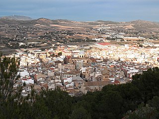
Yecla is a town and municipality in eastern Spain with 35243 people registered, in the extreme north of the autonomous community of Murcia, located 96 km from the capital of the region, Murcia.

<span class="mw-page-title-main">Mazarrón</span> Municipality in Region of Murcia, Spain

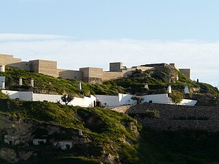
Mazarrón is a municipality in the autonomous community and province of Murcia, southeastern Spain. The municipality has an area of 318.7 square kilometres (123.1 sq mi), and a population of 31,562 inhabitants in 2019. A military fort which was built between 1930 and 1936 during the reign of Alfonso XIII of Spain and the Second Spanish Republic exists as a tourist attraction on the old road between Mazarrón and Cartagena, and although it is accessible from the Bay of Mazarrón it is not in the municipality itself.

<span class="mw-page-title-main">Totana</span> Municipality in Murcia, Spain

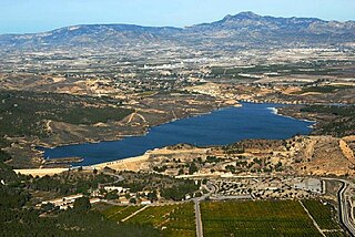
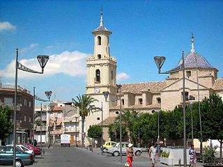
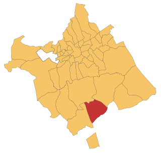
Totana is a municipality in the Region of Murcia in Spain. It has a population of 32008. The local economy is largely dependent on agriculture and related industries. It has a railway station providing a service on the Cercanías Murcia/Alicante commuter line, providing connections to Alicante and Murcia.

<span class="mw-page-title-main">Calasparra</span> Municipality in Murcia, Spain

Calasparra is a municipality in the autonomous community of Murcia, Spain. It shares borders with Cieza, Mula, Cehegín, Moratalla and province of Albacete.

<span class="mw-page-title-main">Abanilla</span> Municipality in Murcia, Spain

Abanilla is a Spanish municipality located in the Comarca Oriental in the Autonomous Community of Murcia. It lies close to the border of the province of Alicante in the Autonomous Community of Valencia.

<span class="mw-page-title-main">La Unión, Murcia</span> Municipality in Region of Murcia, Spain

La Unión is situated in the Region of Murcia in the southeast of Spain. It has an area of 24.6 km², and had a population of 19,907 on 1 January 2018. It has an elevation of 86 m. Its average annual temperature is 17 °C. It has balmy winters. The sun shines 320 days per year. La Unión is situated in one of the sunniest areas in Europe; this kind of climate makes possible the many leisure activities, popular fiestas, sports, and cultural activities that are held in the town. The town is linked by a regular train to Cartagena which allows views of the past industrial heritage of the area and the more modern occupations of agriculture and tourism. La Unión lies within the built-up area of Cartagena and is surrounded on all landward sides by the City of Cartagena.

<span class="mw-page-title-main">Alcantarilla</span> Municipality in Region of Murcia, Spain

Alcantarilla is a town and municipality in southeastern Spain, in the Autonomous Community of the Region of Murcia. The town is only 7 km away from the capital of the region, the city of Murcia, and one of its peculiarities is that it is completely surrounded by "pedanías" of the municipality of Murcia like Sangonera La Seca, San Ginés, Nonduermas, Puebla de Soto, La Ñora, Javalí Viejo and Javalí Nuevo.

<span class="mw-page-title-main">Carche</span> Area in the Region of Murcia, Spain

Carche is a mountainous, sparsely populated area in the Region of Murcia, Spain, lying between the municipalities of Jumilla and Yecla. The mountains reach an elevation of 1,371 metres at the Pico de la Madama and part of the region has the status of regional park. Three villages border the park: Raspay, La Alberquilla and Carche, with a total of 182 inhabitants (2005).

<span class="mw-page-title-main">Molina de Segura</span> Municipality in Murcia, Spain

Molina de Segura is a municipality of Spain in the autonomous community and province of Murcia. It is located 10 km from the provincial capital, Murcia.

<span class="mw-page-title-main">Tibi, Alicante</span>

Tibi is a municipality in the comarca of Alcoià, Alicante, Valencia, Spain. The name of this municipality comes from Latin and it means "for you". This territory was populated with 1,564 people in the year 2018.

<span class="mw-page-title-main">Fuente Álamo de Murcia</span> Municipality in Murcia, Spain

Fuente Álamo de Murcia is a town and municipality in the Region of Murcia, southern Spain. It is situated 22 km northwest of Cartagena and 35 km south west of Murcia. The town lies in the basin of the Mar Menor surrounded by the mountains of Algarrobo, Los Gómez, Los Victorias and the Carrascoy.

<span class="mw-page-title-main">Puerto Lumbreras</span> Municipality in Region of Murcia, Spain

Puerto Lumbreras is a Spanish municipality in the autonomous community of Murcia. It has a population of 15,780 (2020) and an area of 139 km2. It is located in the southwestern end of Region of Murcia and is adjacent to Andalusia.

<span class="mw-page-title-main">Santomera</span> Municipality in Region of Murcia, Spain

Santomera is a Spanish municipality in the autonomous community of Murcia. It has a population of 16,105 (2018) and an area of 44.2 km2. It shares borders with Fortuna in the north, with Murcia in its west and south and with the province of Alicante in the east.

<span class="mw-page-title-main">Torre-Pacheco</span> Municipality in Region of Murcia, Spain

Torre-Pacheco is a municipality in the autonomous community of Murcia in southeastern Spain. It covers an area of 189.4 km2 and its population in 2019 was 35,676. The only high ground in the municipality is Cabezo Gordo hill, the location of the protected Sima de las Palomas archeological site. The town has one secondary education institution, the I.E.S. Gerardo Molina.

<span class="mw-page-title-main">Region of Murcia</span> Autonomous community and province of Spain

The Region of Murcia is an autonomous community of Spain located in the southeastern part of the Iberian Peninsula, on the Mediterranean coast. The region is 11,313 km2 (4,368 sq mi) in area and had a population of 1,511,251 as at the start of 2020. About a third of its population lives in the capital, Murcia, and a seventh in the second city, Cartagena. At 2,014 m (6,608 ft), the region's highest point is Los Obispos Peak in the Massif of Revolcadores.

<span class="mw-page-title-main">Aledo, Spain</span> Municipality in Murcia, Spain

Aledo is a municipality in the Region of Murcia, southern Spain.

<span class="mw-page-title-main">Cartagena, Spain</span> Municipality in Region of Murcia, Spain

Cartagena is a Spanish city and a major naval station on the Mediterranean coast, south-eastern Iberia. As of January 2018, it has a population of 218,943 inhabitants. This makes Cartagena Murcia's second-largest municipality and Spain's sixth-largest city that is not a provincial-capital. The wider urban or metropolitan area of Cartagena, known as Campo de Cartagena, has a population of 409,586 inhabitants.

<span class="mw-page-title-main">Fortuna, Murcia</span> Municipality in Murcia, Spain

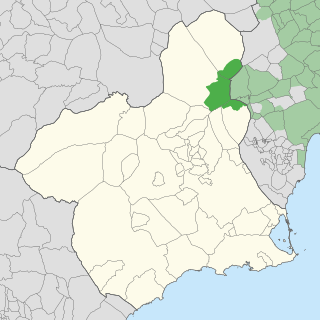
Fortuna is a town and a municipality in the autonomous Region of Murcia in southeastern Spain. It is located in the northeast of the region and in Comarca Oriental. The municipality shares borders with Abanilla at its east, Jumilla and Abarán at is north, Blanca at its northwest, Molina at its west and southwest and Murcia and Santomera at its south.

<span class="mw-page-title-main">Los Martínez del Puerto</span> Place in Murcia, Spain

Los Martínez del Puerto is a village in Murcia, Spain. It is part of the municipality of Murcia.

References

  1. Municipal Register of Spain 2018. National Statistics Institute.
  2. "INEbase / Demography and population /Municipal Register. Population by municipality /Nomenclature: Continuous Register Population by Population Unit / Results" . Retrieved 28 January 2019.
  3. "Ayuntamiento de Jumilla - Situación Geográfica" (in Spanish). Retrieved 2018-10-02.
  4. "Ayuntamiento de Jumilla - Medio Natural" (in Spanish). Retrieved 2020-04-27.
  5. "HUMEDALES Y RAMBLAS (Q-3.3)" (in Spanish). pp. 59, 60. Retrieved 2020-04-27.
  6. "Jumilla - Región de Murcia Digital" (in Spanish). Retrieved 2020-04-27.
  7. "Pedanías de Jumilla - Región de Murcia Digital" (in Spanish). Retrieved 2020-04-30.
  8. "INEbase / Demography and population /Municipal Register. Population by municipality /Nomenclature: Continuous Register Population by Population Unit / Results". INE. Retrieved 2020-04-30.
  9. 1 2 3 "Historia de Jumilla- Prehistoria - Región de Murcia Digital" (in Spanish). Retrieved 2018-11-17.
  10. "Historia de Jumilla- Antigüedad - Región de Murcia Digital".
  11. 1 2 3 "Historia de Jumilla- Edad Media - Región de Murcia Digital".
  12. List of photovoltaic power stations
  13. "Powering 20,000 Homes: The World's Largest PV Solar Farm Opens". treehugger.com.[ permanent dead link ]
  14. European Association for Animal Production (1978), "Ruminant production in the dry subtropics: constraints and potentials", EAAP Publication (38), Butterworths: 68, ISBN   978-90-220-0949-9
  15. "Enoturismo, visitas a bodegas y escapadas para hacer y regalar".
  16. "Ayuntamiento de Jumilla - Patrimonio" (in Spanish). Retrieved 2020-04-29.
  17. "Ermita de San Agustín". WEB Turismo de Jumilla (in Spanish). Retrieved 2021-03-30.
  18. "Ermita de San Antón - Museo de Semana Santa". Web Oficial Turismo Región de Murcia. Retrieved 2021-03-30.
  19. "Ermita San Anton". WEB Turismo Jumilla (in Spanish). Retrieved 2021-03-30.
  20. "Ayuntamiento de Jumilla - Fiestas" (in Spanish). Retrieved 2020-04-30.
  21. "Programa Fiestas Jumilla 2019". La Guía W - La Guía Definitiva, Encuentra lo que quieras, donde quieras (in Spanish). Retrieved 2021-03-31.
  22. "Fiestas de Moros y Cristianos". WEB Turismo Jumilla (in Spanish). Retrieved 2021-03-31.