Abbott Township, Pennsylvania | |
---|---|
Township | |
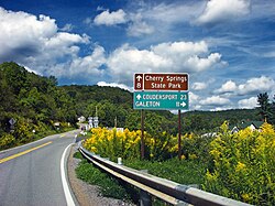
![]() Pennsylvania Route 44 in Abbott Township at Carter Camp | |
Map of Potter County, Pennsylvania highlighting Abbott Township | |
![]() Map of Potter County, Pennsylvania | |
Coordinates: 41°35′00″N77°36′59″W / 41.583333333333°N 77.616388888889°W | |
Country | United States |
State | Pennsylvania |
County | Potter |
Incorporated | 1856 |
Government | |
• Type | Board of Supervisors |
• Chairman | Joseph Sutton |
• Vice-chairman | Jake Hastings |
• Roadmaster | Duane Cizek |
• Secretary/Treasurer | Linda S. Culp |
• Tax Collector | Mary May |
Area | |
• Total | 69.98 sq mi (181.24 km2) |
• Land | 69.98 sq mi (181.24 km2) |
• Water | 0.00 sq mi (0.00 km2) |
Population | |
• Total | 230 ![]() |
• Estimate (2021) [2] | 228 |
• Density | 3.34/sq mi (1.29/km2) |
Time zone | UTC-5 (EST) |
• Summer (DST) | UTC-4 (EDT) |
FIPS code | 42-105-00108 |
Website | Abbot Township |
Abbott Township is a township in Potter County, Pennsylvania, United States. The population was 230 at the 2010 census. [2]
According to the United States Census Bureau, the township has a total area of 69.9 square miles (181 km2), all land. It is bordered by Tioga County to the east, Stewardson Township to the south, Wharton Township to the west and West Branch Township to the north.
Census | Pop. | Note | %± |
---|---|---|---|
2010 | 242 | — | |
2020 | 230 | −5.0% | |
2021 (est.) | 228 | [2] | −0.9% |
As of the census [3] of 2000, there were 226 people, 88 households, and 69 families residing in the township. The population density was 3.2 people per square mile (1.2/km2). There were 457 housing units at an average density of 6.5/sq mi (2.5/km2). The racial makeup of the township was 99.12% White, and 0.88% from two or more races.
There were 88 households, out of which 26.1% had children under the age of 18 living with them, 71.6% were married couples living together, 5.7% had a female householder with no husband present, and 20.5% were non-families. 18.2% of all households were made up of individuals, and 8.0% had someone living alone who was 65 years of age or older. The average household size was 2.57 and the average family size was 2.86.
In the township the population was spread out, with 22.6% under the age of 18, 3.1% from 18 to 24, 25.7% from 25 to 44, 33.6% from 45 to 64, and 15.0% who were 65 years of age or older. The median age was 44 years. For every 100 females, there were 119.4 males. For every 100 females age 18 and over, there were 116.0 males.
The median income for a household in the township was $25,250, and the median income for a family was $26,250. Males had a median income of $26,667 versus $15,625 for females. The per capita income for the township was $14,068. About 2.7% of families and 6.1% of the population were below the poverty line, including 4.3% of those under the age of 18 and 8.9% of those 65 or over.
Fox Lake Hills is an unincorporated community and census-designated place (CDP) in Lake Villa Township, Lake County, Illinois, United States. Per the 2020 census, the population was 2,684.
Wilcox Township is a civil township of Newaygo County in the U.S. state of Michigan. The population was 1,133 at the 2020 census.
Blind Lake Township is a township in Cass County, Minnesota, United States. The population was 88 as of the 2000 census.
Byron Township is a township in Cass County, Minnesota, United States. The population was 118 as of the 2000 census.
South Red River Township is a township in Kittson County, Minnesota, United States. The population was 23 at the 2000 census.
Custer Township is a township in Lyon County, Minnesota, United States. The population was 220 at the 2000 census.
Ben Wade Township is a township in Pope County, Minnesota, United States. The population was 252 at the 2000 census.
Charlestown Township is one of the twenty-six townships of Redwood County, Minnesota, United States. The population was 217 at the 2000 census.
Skagen Township is a township in Roseau County, Minnesota, United States. The population was 235 at the 2000 census.
White Oak is a census-designated place (CDP) in Hamilton County, Ohio, United States. It is seven miles northwest of Cincinnati. The population was 19,541 at the 2020 census. White Oak is situated in both Green Township and Colerain Township.
Chest Township is a township in Clearfield County, Pennsylvania, United States. The population was 510 at the 2020 census.
Harborcreek Township is a township in Erie County, Pennsylvania, United States. The population was 16,630 at the 2020 census, down from 17,234 at the 2010 census, up from 15,178 in 2000. It is part of the Erie Metropolitan Statistical Area.
Elmhurst Township is a township in Lackawanna County, Pennsylvania, United States. The population was 836 at the 2020 census.
Spring Brook Township is a township in Lackawanna County, Pennsylvania, United States. The population was 2,753 at the 2020 census.
West Salem Township is a township in Mercer County, Pennsylvania, United States. The population was 3,220 at the 2020 census, a decrease from 3,538 in 2010.
Southwest Madison Township is a township in Perry County, Pennsylvania, United States. The population was 1,020 at the 2020 census.
Barry Township is a township in Schuylkill County, Pennsylvania. Formed in 1822, it is named for American Revolutionary War Commander John Barry and was formed from parts of Norwegian and Schuylkill Townships.
Franklin Township is a township in Susquehanna County, Pennsylvania, United States. The population was 833 at the 2020 census. Salt Springs State Park, a Pennsylvania state park, is in Franklin Township.
Scrubgrass Township is a township in Venango County, Pennsylvania, United States. The population was 750 at the 2020 census.
Farmington Township is a township in Warren County, Pennsylvania, United States. The population was 1,281 at the 2020 census, up from 1,259 in 2010.