Abo, New Mexico

Last updated
Abo, New Mexico
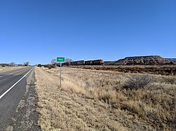
Train, Abo NM.jpg
USA New Mexico location map.svg
Red pog.svg
Abo, New Mexico
Coordinates: 34°27′21″N106°19′59″W / 34.45583°N 106.33306°W / 34.45583; -106.33306
CountryUnited States
State New Mexico
County Torrance
Time zone Mountain (MST)

Abo is an unincorporated community in Torrance County, New Mexico, United States, located on U.S. Route 60. It is the nearest community to Abo, a pueblo and mission ruin of the same name that is a National Historic Landmark. A post office was operated here from 1910 to 1914. [1]

Contents

Geography

The geography around Abo is defined by the red sandstone in low mesas and stream cuts. [2]

Nearby Communities

Transportation

Major Airports

Major Highways

Related Research Articles

<span class="mw-page-title-main">Torrance County, New Mexico</span> County in New Mexico, United States

Torrance County is a county located in the center of the U.S. state of New Mexico. As of the 2020 census, the population was 15,045. The county seat is Estancia.

<span class="mw-page-title-main">Treutlen County, Georgia</span> County in Georgia, United States

Treutlen County is a county located in the east central and Magnolia midlands portion of the U.S. state of Georgia. As of the 2020 census, the population was 6,406. The county seat is Soperton. Treutlen County is host to the Million Pines Arts and Crafts Festival which takes place during the first weekend in November.

<span class="mw-page-title-main">Jackson County, Colorado</span> County in Colorado, United States

Jackson County is a county located in the U.S. state of Colorado. As of the 2020 census, the population was 1,379, and it was the fourth least populated in the state. The county is named after the United States President Andrew Jackson. The county seat and only municipality in the county is Walden.

<span class="mw-page-title-main">Moran Township, Michigan</span> Civil township in Michigan, United States

Moran Township is a civil township of Mackinac County in the U.S. state of Michigan. The population was 1,029 at the 2020 census.

<span class="mw-page-title-main">Neshannock Township, Pennsylvania</span> Township in Pennsylvania, United States

Neshannock Township is a township in Lawrence County, Pennsylvania, United States. The population was 9,609 at the 2010 census.

Newman is a small El Paso neighborhood in far Northeast El Paso, located some 16 miles northeast of downtown El Paso around the intersection of Dyer Street and Edge of Texas Drive on the New Mexico state line, and still sometimes described as a separate community. In 1990, it had a population of approximately 60 people.

<span class="mw-page-title-main">U.S. Route 60</span> Numbered U.S. Highway in the United States

U.S. Route 60 is a major east–west United States highway, traveling 2,655 miles (4,273 km) from southwestern Arizona to the Atlantic Ocean coast in Virginia. The highway's eastern terminus is in Virginia Beach, Virginia, where it is known as General Booth Boulevard, just south of the city's Oceanfront resort district at the intersection of Rudee Point Road and Harbor Point. Its original western terminus was in Springfield, Missouri; it was then extended to Los Angeles, California, but in 1964, it was truncated to end southwest of Brenda, Arizona, at an interchange with Interstate 10 (I-10) after the US 60 highway designation was removed from California. I-10 replaced US 60 from Beaumont, California, to Arizona, and California State Route 60 (SR 60) replaced US 60 from Los Angeles to Beaumont.

<span class="mw-page-title-main">U.S. Route 84</span> United States Numbered Highway in the United States

U.S. Route 84 (US 84) is an east–west United States Numbered Highway that started as a short Georgia–Alabama route in the original 1926 scheme. Later, in 1941, it had been extended all the way to Colorado. The highway's eastern terminus is a short distance east of Midway, Georgia, at an Interchange with I-95. The road continues toward the nearby Atlantic Ocean as a county road. Its northern terminus is in Pagosa Springs, Colorado, at an intersection with US 160.

<span class="mw-page-title-main">U.S. Route 62</span> Highway in the United States

U.S. Route 62 or U.S. Highway 62 (US 62) is an east–west United States Highway in the southern and northeastern United States. It runs from the Mexican border at El Paso, Texas, to Niagara Falls, New York, near the Canadian border. It is the only east–west United States Numbered Highway that connects Mexico and Canada. Parts of US 62 follow what once was the Ozark Trail, including the historic bridge across the South Canadian River in Newcastle, Oklahoma. This bridge was damaged beyond repair by the 2013 Moore tornado that struck Newcastle and Moore, Oklahoma. The highway runs north–south in New York and Pennsylvania.

<span class="mw-page-title-main">Extreme points of North America</span> Most prominent locations of the continents physical boundaries

This is a list of the extreme points of North America: the points that are highest and lowest, and farther north, south, east or west than any other location on the continent. Some of these points are debatable, given the varying definitions of North America.

<span class="mw-page-title-main">Virginia State Route 156</span> State highway in eastern Virginia, US

State Route 156 is a primary state highway in the U.S. state of Virginia. The state highway runs 57.38 miles (92.34 km) from U.S. Route 301 and SR 35 in Templeton north to US 360 Business in Mechanicsville. SR 156 follows a circuitous route through the eastern part of the Richmond–Petersburg metropolitan area. South of the James River, the state highway connects Templeton in Prince George County with Hopewell, which is directly served by SR 156 Business. SR 156 crosses the James River on the Benjamin Harrison Memorial Bridge and briefly passes through Charles City County. For most of its length in Henrico and Hanover, the state highway is a rural road that provides access to several units of Richmond National Battlefield Park. However, SR 156 provides access to Richmond International Airport, Interstate 64 (I-64), and I-295 as it passes through the Richmond suburbs of Sandston and Highland Springs as a major highway.

<span class="mw-page-title-main">San Bernardino Valley</span> Valley in California, United States

The San Bernardino Valley is a valley in Southern California located at the south base of the Transverse Ranges. It is bordered on the north by the eastern San Gabriel Mountains and the San Bernardino Mountains; on the east by the San Jacinto Mountains; on the south by the Temescal Mountains and Santa Ana Mountains; and on the west by the Pomona Valley. Elevation varies from 590 feet (180 m) on valley floors near Chino to 1,380 feet (420 m) near San Bernardino and Redlands. The valley floor is home to over 80% of the more than 4 million people in the Inland Empire region.

<span class="mw-page-title-main">Georgia State Route 56</span> State highway in Georgia, United States

State Route 56 (SR 56) is an inverted question mark-shaped state highway that travels south-to-north, with a western loop around Vidalia. It is 140.3-mile-long (225.8 km) and travels through portions of Tattnall, Toombs, Montgomery, Treutlen, Emanuel, Burke, and Richmond counties in the southeastern and east-central parts of the U.S. state of Georgia. The route connects the Reidsville and Augusta areas, via Swainsboro and Waynesboro.

The United States Border Patrol operates 71 traffic checkpoints, including 33 permanent traffic checkpoints, near the Mexico–United States border. The stated primary purpose of these inspection stations is to deter illegal immigration and smuggling activities. After the September 11 attacks in 2001, they took on the additional role of terrorism deterrence. These checkpoints are located between 25 and 75 miles of the Mexico–United States border along major U.S. highways; near the southern border of the contiguous United States. Their situation at interior locations allow them to deter illegal activities that may have bypassed official border crossings along the frontier. The checkpoints are divided among nine Border Patrol sectors. There are a number of these checkpoints near the northern border of the contiguous U.S. as well, within 100 miles (160 km) of the Canada–U.S. border.

The Harcuvar Mountains are a narrow mountain range in western-central Arizona, United States. The range lies just east of the north–south Colorado River, and south of the east–west, west-flowing Bill Williams River, from Alamo Lake.

<span class="mw-page-title-main">San Augustin Mountains</span> Mountain subrange of the San Andres Mountains

The San Augustin Mountains are a small mountain subrange located at the southern terminus of the San Andres Mountains east of Las Cruces, New Mexico.

<span class="mw-page-title-main">Abo Canyon</span> Mountain pass in New Mexico, United States

Abo Canyon, also known as Abo Pass, is a mountain pass at the southern end of the Manzano Mountains of central New Mexico in the Southwest United States.

<span class="mw-page-title-main">Eli, Nebraska</span> Unincorporated Community in Nebraska, United States

Eli is an unincorporated community in Cherry County, Nebraska, United States. Its population is approximately 60-75 people, but exact census information has not been collected. It is one mile (1.6 km) north of U.S. Route 20 and 2.5 miles (4.0 km) south of the Nebraska-South Dakota border. The nearest town is Merriman, 11.8 miles (19.0 km) to the west. It is also 12.8 miles (20.6 km) west of Cody.

Chili is an unincorporated community and census-designated place in Rio Arriba County, New Mexico. Its population was 654 as of the 2010 census. U.S. Route 84 passes through the community. The name comes from a station of the D&RG railroad that was known locally as the "Chili Line."

References

  1. Julyan, Robert (1996). The Place Names of New Mexico. University of New Mexico Press. p. 2. ISBN   0826316891.
  2. https://geoinfo.nmt.edu/publications/maps/geologic/ofgm/downloads/199/OFGM-199_Abo_Report.pdf

34°27′21″N106°19′59″W / 34.45583°N 106.33306°W / 34.45583; -106.33306