Abteiland

Last updated
Landscape in the Abteiland near Waldkirchen Abteiland.JPG
Landscape in the Abteiland near Waldkirchen

The Abteiland ("Abbey Land") is a former estate owned by Niedernburg Abbey above Passau. From the early 13th century until the seizure of church property under Napoleon in 1803, the region belonged to the Hochstift or Prince-Bishopric of Passau with the prince bishop as its secular and spiritual head. The region lies in the Bavarian Forest north of the River Danube and east of the River Ilz. It was crossed by a historical trade route, the Goldener Steig ("Golden Trail"). Its main settlement was Waldkirchen, which was granted wide-ranging rights by the prince bishops of Passau.

Contents

The Abteiland has great significance as a cultural landscape rich in species and habitats and is viewed as a refugium for endangered plants and animals. Together with the Neuburg Forest it forms natural region no. 408 - the Passau Abteiland and Neuburg Forest - within the Upper Palatine-Bavarian Forest.

In April 2011, the Abteiland Working Group was formed from the following eleven municipalities: [1]

MunicipalityPopulation
2011
Area
(km2)
Coordinates
Hauzenberg 12.02582,82 48°39′N13°37′E / 48.650°N 13.617°E / 48.650; 13.617 (Hauzenberg)
Thyrnau 4.23533,68 48°37′N13°32′E / 48.617°N 13.533°E / 48.617; 13.533 (Thyrnau)
Obernzell 3.85018,25 48°33′N13°38′E / 48.550°N 13.633°E / 48.550; 13.633 (Obernzell)
Untergriesbach 3.10473,60 48°34′N13°40′E / 48.567°N 13.667°E / 48.567; 13.667 (Untergriesbach)
Sonnen 1.44716,48 48°41′N13°43′E / 48.683°N 13.717°E / 48.683; 13.717 (Sonnen)
Wegscheid 5.51780,68 48°36′N13°47′E / 48.600°N 13.783°E / 48.600; 13.783 (Wegscheid)
Breitenberg 2.17329,87 48°42′N13°48′E / 48.700°N 13.800°E / 48.700; 13.800 (Breitenberg)
Neureichenau 4.39646,38 48°45′N13°45′E / 48.750°N 13.750°E / 48.750; 13.750 (Neureichenau)
Haidmühle 1.38821,03 48°50′N13°47′E / 48.833°N 13.783°E / 48.833; 13.783 (Haidmühle)
Jandelsbrunn 3.28442,40 48°44′N13°42′E / 48.733°N 13.700°E / 48.733; 13.700 (Jandelsbrunn)
Waldkirchen 10.50780,06 48°44′N13°36′E / 48.733°N 13.600°E / 48.733; 13.600 (Waldkirchen)

History

The Bavarian Forest north of Passau was settled in a first wave in the 9th/10th century. According to a (not wholly authenticated) document, in the year 1010 King Henry II (emperor from 1014) gifted large areas north of the Danube to convent of Niedernburg in Passau. The name Abteiland is still used today for the former estate of the monastery between the rivers Danube, Ilz and Rodl and the border ridge. In the early 13th century, the region came to the Bishopric of Passau. In the late Middle Ages, the area of influence of the Passau magnates and prelates extended as far as the present Mühlviertel in Austria. Waldkirchen played a special role in the Abteiland. With the first written confirmation of market rights in 1285, Waldkirchen was also received its own jurisdiction from the prince bishop of Passau, which was the lowest level of legal authority. There used to be a pillory on the market place, Waldkirchner Marktplatz.

The market town judge was appointed by the prince-bishop and had performed functions like that of a mayor. He performed his duties along with six council members. At the annual E'haft (Ehehaft = 'sitting', from the Germanic Ewa or Eha = law) meeting, legal, police and municipal matters were dealt with. All citizens and residents (non-citizens) had to participate.

Traditions

Every year in July in Waldkirchen, the Market Judge Days (Marktrichtertage) are held as a traditional event. They recall the time when the market was still a part of the Prince Bishopric of Passau.

Related Research Articles

<span class="mw-page-title-main">Regensburg</span> City in Bavaria, Germany

Regensburg is a city in eastern Bavaria, at the confluence of the Danube, Naab and Regen rivers, Danube's northernmost point. It is the capital of the Upper Palatinate subregion of the state. With more than 150,000 inhabitants, Regensburg is the fourth-largest city in the State of Bavaria after Munich, Nuremberg and Augsburg and the 8th largest of all cities on the Danube river. From its foundation as an imperial Roman river fort, the city has been the political, economic and cultural centre of the surrounding region. Later, under the rule of the Holy Roman Empire, it housed the Perpetual Diet of Regensburg.

<span class="mw-page-title-main">Upper Palatinate</span> Regierungsbezirk (administrative district) in Bavaria, Germany

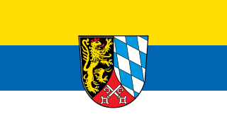
The Upper Palatinate is an administrative district in the east of Bavaria, Germany. It consists of seven districts and 226 municipalities, including three cities.

Passau is a Landkreis (district) in the southeast of Bavaria, Germany. It encloses the city of Passau geographically from two sides. Neighboring districts are Rottal-Inn, Deggendorf, Freyung-Grafenau. To the south it borders Austria.

<span class="mw-page-title-main">Passau</span> University town in Lower Bavaria, Germany

Passau is a city in Lower Bavaria, Germany. It is also known as the Dreiflüssestadt as the river Danube is joined by the Inn from the south and the Ilz from the north.

<span class="mw-page-title-main">Bavarian Forest</span> Region in Bavaria, Germany

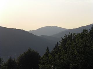
The Bavarian Forest is a wooded, low-mountain region in Bavaria, Germany that is about 100 kilometres long. It runs along the Czech border and is continued on the Czech side by the Bohemian Forest. Most of the Bavarian Forest lies within the province of Lower Bavaria, but the northern part lies within Upper Palatinate. In the south it reaches the border with Upper Austria.

Freyung-Grafenau is a Landkreis (district) in Bavaria, Germany. It is bounded by the districts of Passau, Deggendorf and Regen, the Czech Republic and by Austria.

<span class="mw-page-title-main">Roman Catholic Diocese of Passau</span> Catholic diocese in Germany

The Diocese of Passau is a Latin diocese of the Catholic Church in Germany that is a suffragan of the Archdiocese of Munich and Freising. The Prince-Bishopric of Passau was an ecclesiastical principality that existed for centuries until it was secularized in 1803. The diocese covers an area of 5,442 km².

<span class="mw-page-title-main">Veste Oberhaus</span> Fortress in Germany

Veste Oberhaus is a fortress that was founded in 1219 and, for most of its time, was the stronghold of the Bishop of Passau, Germany. It is now the site of a museum, a youth hostel and a restaurant, as well as an open-air theatre dating to 1934.

<span class="mw-page-title-main">Waldkirchen</span> Town in Bavaria, Germany

Waldkirchen is the biggest town in the district of Freyung-Grafenau in Germany.

<span class="mw-page-title-main">Neuburg am Inn</span> Municipality in Bavaria, Germany

Neuburg am Inn is a municipality in the district of Passau in Bavaria in Germany.

<span class="mw-page-title-main">Tiefenbach, Passau</span> Municipality in Bavaria, Germany

Tiefenbach is a municipality in the district of Passau in Bavaria in Germany.

<span class="mw-page-title-main">Sankt Englmar</span> Municipality in Bavaria, Germany

Sankt Englmar is a municipality in the district of Straubing-Bogen in Bavaria, Germany.

<span class="mw-page-title-main">Untergriesbach</span> Municipality in Bavaria, Germany

Untergriesbach is a municipality in the district of Passau in Bavaria in Germany.

The Deggendorf–Kalteneck railway linked the railway line running through the Bavarian Forest from Plattling via Zwiesel to Bayerisch Eisenstein with the Ilz Valley railway (Ilztalbahn) from Passau via Waldkirchen to Freyung. In keeping with the naming of the Bavarian Forest railway or Waldbahn from Plattling to Bayerisch Eisenstein, it was called the Vorwaldbahn.

<span class="mw-page-title-main">Passau–Freyung railway</span>

The Passau–Freyung railway, also known as the Ilz Valley Railway or Ilztalbahn, is a branch line in Bavaria, Germany. It runs from Passau to the town of Freyung in the Bavarian Forest. At Kalteneck it forms a junction with the branch line to Eging-Deggendorf. At Waldkirchen the Waldkirchen–Haidmühle line branches off towards the Czech border, where since 1945 there has been a junction with the Czech railway network.

The Upper Palatine-Bavarian Forest, is a natural region in Germany in the northeast of Bavaria. It mainly comprises the low mountain ranges of the Bavarian Forest and Upper Palatine Forest which are up to 1456 m high and border on the Bohemian Massif immediately inside the Czech Republic's southwestern border with Germany.

<span class="mw-page-title-main">Prince-Bishopric of Freising</span> Ecclesiastical principality of the Holy Roman Empire

The Prince-Bishopric of Freising was an ecclesiastical principality of the Holy Roman Empire from 1294 until its secularisation in the early years of the 19th century.

<span class="mw-page-title-main">Leopold Leonard, Count of Thun</span>

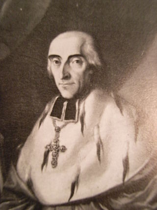
Leopold Leonhard Raymund Count of Thun and Hohenstein was the 73rd Bishop of Passau and the last Prince-Bishop of Passau.

<span class="mw-page-title-main">Anterior Bavarian Forest</span>

The Anterior Bavarian Forest, also variously called the Vorderer Forest, Vorderer Wald or Danube Hills, is part of the Bavarian Forest, a low mountain range in Germany.

<span class="mw-page-title-main">Neuburg Forest</span>

The Neuburg Forest is a largely forested hill ridge and natural region in Lower Bavaria in the county of Passau and the borough of Passau. It is named after the village of Neuburg am Inn.

References

  1. TRP1 Fernsehen (2011-04-12). "ARGE Abteiland gegründet" (in German). Tele Regional Passau 1. Retrieved 2013-10-20.{{cite web}}: CS1 maint: numeric names: authors list (link)[ permanent dead link ]