The Han River is a river in the central region of the Korean peninsula. It is classified as a national first-class river in South Korea. The term "Miracle on the Han River," referring to South Korea's rapid economic growth, originates from this river. The Han river currently has eight river islands: Nodeulseom, Ttukseom, Yeouido, Bamseom, Seoraeseom, Sebitseom, and Yeoido.

Gyeonggi-do is the most populous province in South Korea.

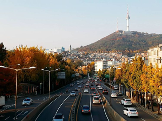
The N Seoul Tower, officially the YTN Seoul Tower and a.k.a. the Namsan Tower is a communication and observation tower located on Namsan Mountain in central Seoul, South Korea. The 236-meter (774 ft)-tall tower marks the second highest point in Seoul and is considered a local landmark.

Guri is a city in Gyeonggi Province, South Korea. It is located immediately to the east of Seoul, in the heart of the Capital Metropolitan Area.
Yongsan District is one of the 25 districts of Seoul, South Korea.

Bukhansan, or Bukhan Mountain, is a mountain on the northern periphery of Seoul, South Korea. There are three major peaks, Baegundae 836.5 meters (2,744 ft), Insubong 810.5 meters (2,659 ft), Mangyeongdae 787.0 meters (2,582.0 ft). Because of its height and the fact that it borders a considerable portion of the city, Bukhansan is a major landmark visible from most city districts. The name "Bukhansan" means "mountain north of Han River", referring to the fact that it is the northern border of the city. During the Joseon era, the peaks marked the extreme northern boundary of Seoul.

Tourism in South Korea and its industry caters to both foreign and domestic tourists. In 2023, 17.2 million foreign tourists visited South Korea, making it the 20th most visited country in the world. Most non-Korean tourists come from East Asia and North America, such as Taiwan and the United States. The popularity of Korean popular culture, often known as the "Korean Wave", in countries around the world has significantly increased tourist arrivals.

In Seoul, public transit buses are operated by the Seoul Metropolitan Government and private bus operators. The city maintains a quasi-public system where the city manages where the routes run, but private companies manage the running of the individual routes themselves.

Seorae Village (Korean: 서래마을), sometimes nicknamed "Montmartre", due to its hilltop location, or sometimes "French Village", is a small, affluent French ethnic enclave in Banpo-dong & Bangbae-dong, Seocho District, Seoul, South Korea. It is home to about 560 French people, roughly 40% of the French community in South Korea. Most of them are employees of French corporations doing business in the country. The majority (370) of the French population are children.

Gwangjin District is one of the 25 districts of Seoul, South Korea. It is located on the north bank of the Han River on the eastern end of Seoul. The district was split from the neighboring Seongdong District in 1995.

Jayang station is a metro station on Seoul Subway Line 7. It is located in Jayang-dong in the Gwangjin-gu administrative district of Seoul. It is the only station in South Korea to be located on the underside of a bridge, beneath Cheongdam Bridge. The station also runs underneath a highway with two exits being south of the highway and two north. The south exits serve Ttukseom Hangang Park, while the north exits serve Jayang 3-dong and Jayang 4-dong which contain some residential towers with small shops and other mixed commercial and residential areas. The station is serviced by a single bus route which is located at exit 4. Before Line 7 opened the station was known as Jayang Station (자양역).

Jungnang District (Jungnang-gu) is one of the 25 gu, or districts, of Seoul, South Korea. It is located on the north side of the Han River.
Ichon-dong is a neighborhood of Yongsan-gu district in Seoul, South Korea. It is located in the southwest of the city proper, along the Han River.
Gwangjang-dong is a dong, neighbourhood of Gwangjin-gu in Seoul, South Korea.
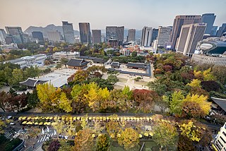
Seoul, officially Seoul Special City, is the capital and largest city of South Korea. The broader Seoul Capital Area, encompassing Gyeonggi province and Incheon Metropolitan City, emerged as the world's sixth largest metropolitan economy in 2022, trailing behind Paris, San Francisco, Los Angeles, Tokyo, and New York, and hosts more than half of South Korea's population. Although Seoul's population peaked at slightly over 10 million, it has gradually decreased since 2014, standing at approximately 9.97 million residents as of 2020. Seoul is the seat of the South Korean government.

The Banpo Bridge (Korean: 반포대교) is a major bridge for vehicular traffic over the Han River in central Seoul, South Korea. It is a double-decked bridge, and is above the pedestrian Jamsu Bridge.
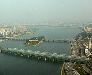
The Hangang Bridge crosses the Han River in Seoul, South Korea. It connects the districts of Yongsan to the north and Dongjak to the south, and crosses over the artificial island of Nodeulseom. The bridge carries eight lanes of traffic.
The Gimpo Goldline is a light metro line opened on 28 September 2019.

Hangang Park (Korean: 한강공원) is a park that consists of 12 parks in Seoul, South Korea. It consists of Gwangnaru Park, Jamsil Park, Ttukseom Park, Jamwon Park, Ichon Park, Banpo Park, Mangwon Park, Yeouido Park, Nanji Park, Gangseo Park, Yanghwa Park, and Seonyudo Park.

The Guri–Amsa Bridge (Korean: 구리암사대교) crosses the Han River in South Korea and connects the city of Guri and Gangdong-gu (district) in Seoul.
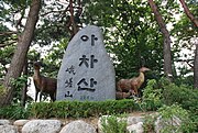 Entrance to one of the mountain's trails (2009)
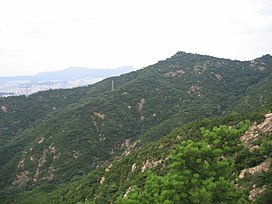
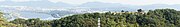 Panorama of Achasan and Achasan Fort, overlooking the Han River (2013)
 Seoul as seen from Achasan (2011)
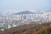 View of Guri, just east of Seoul (2009)