Related Research Articles
Kerrera is an island in the Scottish Inner Hebrides, close to the town of Oban. In 2016 it had a population of 45, divided into two communities in the north and south of the island.
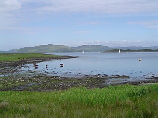
Luing is one of the Slate Islands, Firth of Lorn, in the west of Argyll in Scotland, about 16 miles (26 km) south of Oban. The island has an area of 1,430 hectares and is bounded by several small skerries and islets. It has a population of around 200 people, mostly living in Cullipool, Toberonochy, and Blackmillbay.

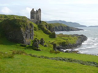
Scarba is an island, in Argyll and Bute, Scotland, just north of the much larger island of Jura. The island was owned by Richard Hill, 7th Baron Sandys, and has not been permanently inhabited since the 1960s. It is now covered in heather and used for grazing animals. Kilmory Lodge is used seasonally as a shooting lodge, the island having a flourishing herd of red deer.

The geology of Great Britain is renowned for its diversity. As a result of its eventful geological history, Great Britain shows a rich variety of landscapes across the constituent countries of England, Wales and Scotland. Rocks of almost all geological ages are represented at outcrop, from the Archaean onwards.

Diabase, also called dolerite or microgabbro, is a mafic, holocrystalline, subvolcanic rock equivalent to volcanic basalt or plutonic gabbro. Diabase dikes and sills are typically shallow intrusive bodies and often exhibit fine grained to aphanitic chilled margins which may contain tachylite. Diabase is the preferred name in North America, while dolerite is the preferred name in the rest of the English-speaking world, where sometimes the name diabase is applied to altered dolerites and basalts. Some geologists prefer the name microgabbro to avoid this confusion.

The North Atlantic Igneous Province (NAIP) is a large igneous province in the North Atlantic, centered on Iceland. In the Paleogene, the province formed the Thulean Plateau, a large basaltic lava plain, which extended over at least 1.3 million km2 (500 thousand sq mi) in area and 6.6 million km3 (1.6 million cu mi) in volume. The plateau was broken up during the opening of the North Atlantic Ocean leaving remnants existing in Northern Ireland, bits of western Scotland, the Faroe Islands, bits of northwestern Iceland, eastern Greenland and western Norway and many of the islands located in the north eastern portion of the North Atlantic Ocean. The igneous province is the origin of the Giant's Causeway and Fingal's Cave. The province is also known as Brito-Arctic province and the portion of the province in the British Isles is also called the British Tertiary Volcanic Province or British Tertiary Igneous Province.
The Lias Group or Lias is a lithostratigraphic unit found in a large area of western Europe, including the British Isles, the North Sea, the Low Countries and the north of Germany. It consists of marine limestones, shales, marls and clays.
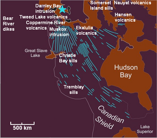
The Mackenzie Large Igneous Province (MLIP) is a major Mesoproterozoic large igneous province of the southwestern, western and northwestern Canadian Shield in Canada. It consists of a group of related igneous rocks that were formed during a massive igneous event starting about 1,270 million years ago. The large igneous province extends from the Arctic in Nunavut to near the Great Lakes in Northwestern Ontario where it meets with the smaller Matachewan dike swarm. Included in the Mackenzie Large Igneous Province are the large Muskox layered intrusion, the Coppermine River flood basalt sequence and the massive northwesterly trending Mackenzie dike swarm.

The Lewisian complex or Lewisian gneiss is a suite of Precambrian metamorphic rocks that outcrop in the northwestern part of Scotland, forming part of the Hebridean Terrane and the North Atlantic Craton. These rocks are of Archaean and Paleoproterozoic age, ranging from 3.0–1.7 billion years (Ga). They form the basement on which the Torridonian and Moine Supergroup sediments were deposited. The Lewisian consists mainly of granitic gneisses with a minor amount of supracrustal rocks. Rocks of the Lewisian complex were caught up in the Caledonian orogeny, appearing in the hanging walls of many of the thrust faults formed during the late stages of this tectonic event.

The Cheviot Hills, or sometimes The Cheviots, are a range of uplands straddling the Anglo-Scottish border between Northumberland and the Scottish Borders. The English section is within the Northumberland National Park. The range includes The Cheviot, plus Hedgehope Hill to the east, Windy Gyle to the west, and Cushat Law and Bloodybush Edge to the south.

The geology of the Isle of Skye in Scotland is highly varied and the island's landscape reflects changes in the underlying nature of the rocks. A wide range of rock types are exposed on the island, sedimentary, metamorphic and igneous, ranging in age from the Archaean through to the Quaternary.
The geology of County Durham in northeast England consists of a basement of Lower Palaeozoic rocks overlain by a varying thickness of Carboniferous and Permo-Triassic sedimentary rocks which dip generally eastwards towards the North Sea. These have been intruded by a pluton, sills and dykes at various times from the Devonian Period to the Palaeogene. The whole is overlain by a suite of unconsolidated deposits of Quaternary age arising from glaciation and from other processes operating during the post-glacial period to the present. The geological interest of the west of the county was recognised by the designation in 2003 of the North Pennines Area of Outstanding Natural Beauty as a European Geopark.
The Cleveland Dyke is an igneous intrusion which extends from Galloway in southern Scotland through Cumbria and County Durham in northern England to the North York Moors in North Yorkshire.
The geology of Tyne and Wear in northeast England largely consists of a suite of sedimentary rocks dating from the Carboniferous and Permian periods into which were intruded igneous dykes during the later Palaeogene Period.
The geology of Northumberland in northeast England includes a mix of sedimentary, intrusive and extrusive igneous rocks from the Palaeozoic and Cenozoic eras. Devonian age volcanic rocks and a granite pluton form the Cheviot massif. The geology of the rest of the county is characterised largely by a thick sequence of sedimentary rocks of Carboniferous age. These are intruded by both Permian and Palaeogene dykes and sills and the whole is overlain by unconsolidated sediments from the last ice age and the post-glacial period. The Whin Sill makes a significant impact on Northumberland's character and the former working of the Northumberland Coalfield significantly influenced the development of the county's economy. The county's geology contributes to a series of significant landscape features around which the Northumberland National Park was designated.
The geology of the Isle of Man consists primarily of a thick pile of sedimentary rocks dating from the Ordovician period, together with smaller areas of later sedimentary and extrusive igneous strata. The older strata was folded and faulted during the Caledonian and Acadian orogenies The bedrock is overlain by a range of glacial and post-glacial deposits. Igneous intrusions in the form of dykes and plutons are common, some associated with mineralisation which spawned a minor metal mining industry.
The geology of Northumberland National Park in northeast England includes a mix of sedimentary, intrusive and extrusive igneous rocks from the Palaeozoic and Cenozoic eras. Devonian age volcanic rocks and a granite pluton form the Cheviot massif. The geology of the rest of the national park is characterised largely by a thick sequence of sedimentary rocks of Carboniferous age. These are intruded by Permian dykes and sills, of which the Whin Sill makes a significant impact in the south of the park. Further dykes were intruded during the Palaeogene period. The whole is overlain by unconsolidated sediments from the last ice age and the post-glacial period.

The geology of the Isle of Mull in Scotland is dominated by the development during the early Palaeogene period of a ‘volcanic central complex’ associated with the opening of the Atlantic Ocean. The bedrock of the larger part of the island is formed by basalt lava flows ascribed to the Mull Lava Group erupted onto a succession of Mesozoic sedimentary rocks during the Palaeocene epoch. Precambrian and Palaeozoic rocks occur at the island's margins. A number of distinct deposits and features such as raised beaches were formed during the Quaternary period.
References
- ↑ "Geology of Britain viewer - British Geological Survey (BGS)". Mapapps.bgs.ac.uk. Retrieved 14 October 2017.
- ↑ "BGS Lexicon of Named Rock Units - Result Detailsk". Bgs.ac.uk. Retrieved 14 October 2017.
- ↑ Stone, P. et al. 2010 British Regional Geology: Northern England (5th edition) (Keyworth, Nottingham. British Geological Survey) p. 243